 
|
|||||||||||
This is a small selection of our inventory of antique Australian prints and maps. Additional inventory is available. Contact us with your request. 1-800-879-6277
|
|||||||||||
|---|---|---|---|---|---|---|---|---|---|---|---|
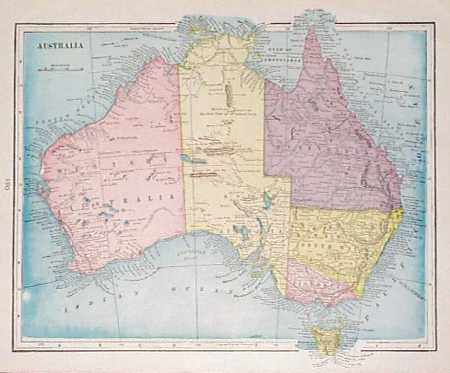
001aus: 1901 Map of Australia. Nice antique map of the Australian continent from a 1907 world atlas, with each state separately colored. Old cities, towns, major roads and geographical features are all marked. Locations of submarine telegraph cables are also shown. 12x15 in. $30 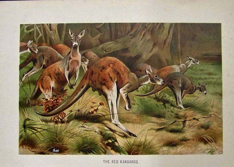 003aus: 1901 Australia Wildlife: Red Kangaroo. Color lithograph from a 1901 natural history text book. Shows a group of red kangaroos hopping through a wooded area. 7x10 in. $60 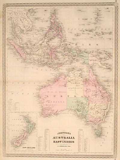
005aus: 1867 Map: Australia, East Indies. Detailed, hand colored map by the A.J. Johnson company. Shows Australia and all of the islands in the East Indies, with a small inset map of New Zealand in the lower left corner. The entire map image is surrounded by a decorative border. 18x26 in. $60  006aus: 1878: Queensland Australia Views. Nicely hand colored engraving from the Nov. 23, 1878 issue of Harper's Weekly. Contains five scenes of people and countryside in Queensland. 11x16 in. $50 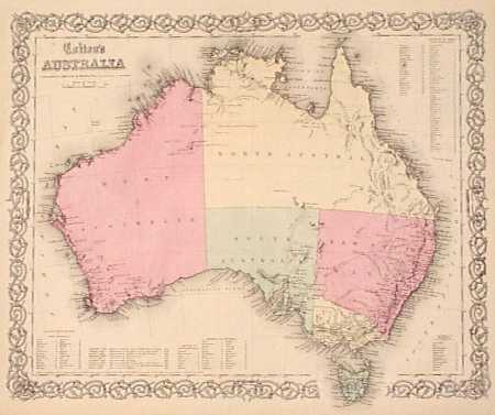 007aus: 1855 Colton Map of Australia. Beautiful map of the Australian continent, with original hand coloring. Cities, towns and geographical features along the coasts are all marked . The most striking feature of this map is the lack of settlements and geographical details in the interior of the continent. The entire map image is surrounded by a decorative border. 15x17 in. $80 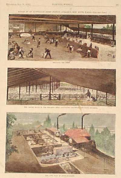 008aus: 1873 Sheep in New South Wales Australia. Three hand colored engravings on one page from the July 19, 1873 issue of Harper's Weekly. Title is "Scenes at an Australian Sheep Station: Collaroy, New South Wales." Each image has its own subtitle: 1) Shearing the Sheep; 2) The Drying Room Floor in the Shearing Shed, Containing 1500 Sheep, One Day's Shearing; and 3) The New Plan of Sheep Washing. There are several light stains on the paper, but overall condition is very good. 11x16 in. $40 |
 009aus: 1897 Map of Australia. Detailed, color map of Australia from the 1897 Century Atlas. Shows cities, towns, railroad lines and geographical features. Submarine telegraph cable locations are also marked. There are inset maps of Melbourne, Sydney and Tasmania in the corners. 12x16 in. $30 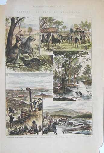 011aus: 1881 Sketches of Life in Queensland. Five handcolored engravings showing: fight with "old man" Kangaroo, a stage coach in the bush, gold mining at Charters Towers, wild duck shooting at Hughenden, on the Burdekin River-Cattle and Alligator. This unique engraving is from the January, 1881 edition of The Illustrated London News. size: 11x16 in. $40 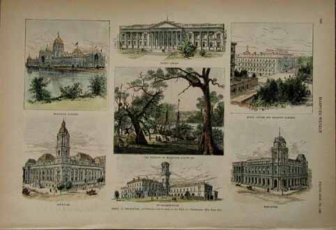 012aus: Seven hand colored engraved images from the September 5, 1885 issue of Harper's Weekly. Page titled Views in Melbourne, Australia. Center image shows The Founding of Melbourne, August, 1835. Surrounding images of the city's major buildings. 11x16 in. $50 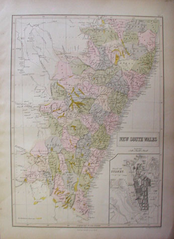 013aus: Beautiful hand colored map of New South Wales. Published in 1857 by A & C Black. Inset in lower right corner of the Plan of Sydney. 12.5x17 in. $70 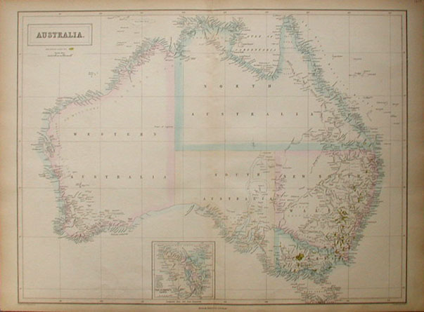
016aus: Large hand colored map of Australia published by A. & C. Black. Published in 1854, shows Australia seperated into Western Australia, North Australia, South Australia and New South Wales. Inset of Van Diemen's Land. 17 X 23.5 in. $60 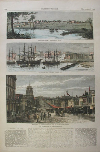 017aus: The Growth of an Australian City. Three views of Melbourne, Australia from the November 27, 1880 issue of Harper's Weekly. Top image captioned, Melbourne, From a Sketch made in 1838. Center image captioned, Melbourne, From a Sketch made in 1855. Bottom image captioned, Melbourne at the Present Time-View in Great Bourke Street. 16x11 in. $60 |
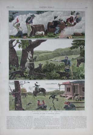 018aus: Adventure and Sport in Queensland, Australia. Hand colored wood engravings from the April 21, 1883 issue of Harper's Weekly. Images titled from top to bottom: Robbing a Bee's Nest, A Kangaroo at Bay, and Slightly Elevated. Short article at bottom titled, Life in Queensland describes the images. 11 x 16 in. $60 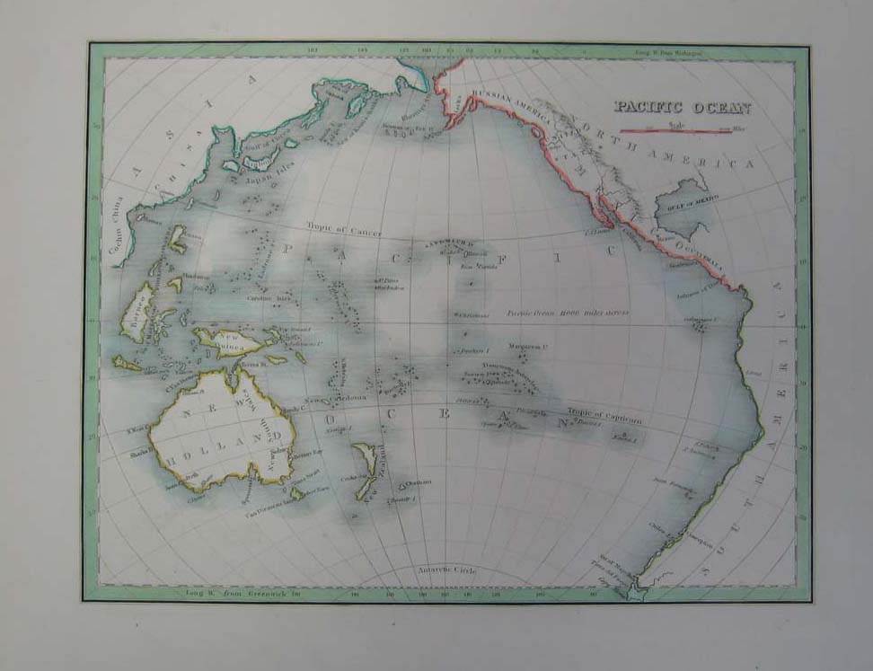 019aus: 1835 Elegant Map of the Pacific Ocean. Intricate hand colored map titled, "Pacific Ocean," from Bradford's 1835 world atlas. Hand colored, engraved map shows continents and islands. 12 x 10 in. $120 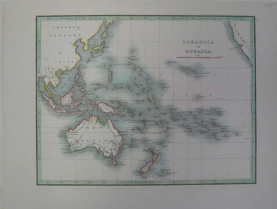 020aus: 1835 Elegant Map of Oceanica or Oceania. Intricate hand colored map titled, "Oceanica or Oceania," from Bradford's 1835 world atlas. Hand colored, engraved map shows the Pacific Ocean and the islands and continents within it. 12 x 10 in. $150 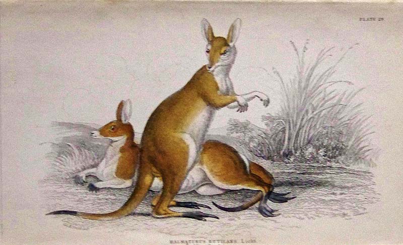 021aus: 1834 Lizars Natural History original hand colored engraving by Jardine on Plate 29 showing the Halmaturas Rutilans Licht (Kangaroo). 6-1/2 x 4 in. $80 
022aus: 1854 Lizars Natural History original hand colored engraving by Jardine titled, "The Kangaroo." 8-1/2 x 5-1/2 in. $80 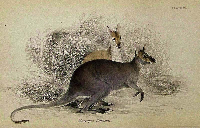
023aus: 1834 Lizars Natural History original hand colored engraving by Jardine on Plate 19 showing the Macropus Bennettii, native to Australia. 6-1/2 x 4 in. $65 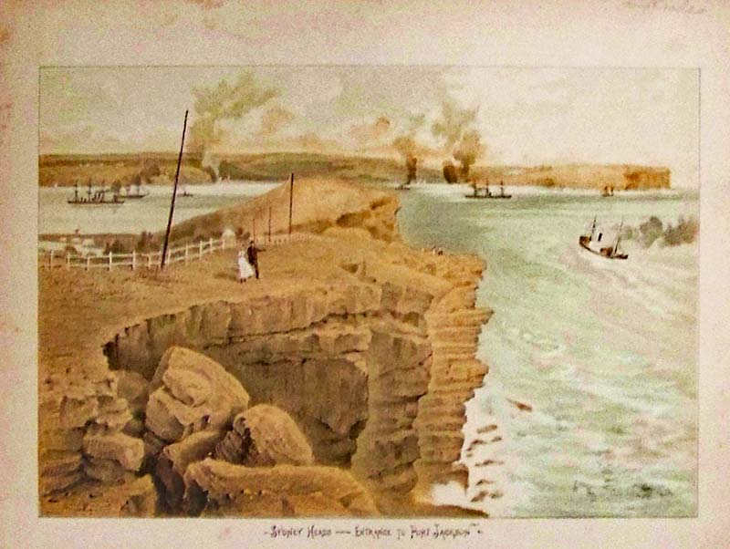
024aus: C.1890 Sydney Heads - Entrance to Port Jackson. This charming chromolithograph also shows a view of several boats. 11 x 8 in. $50 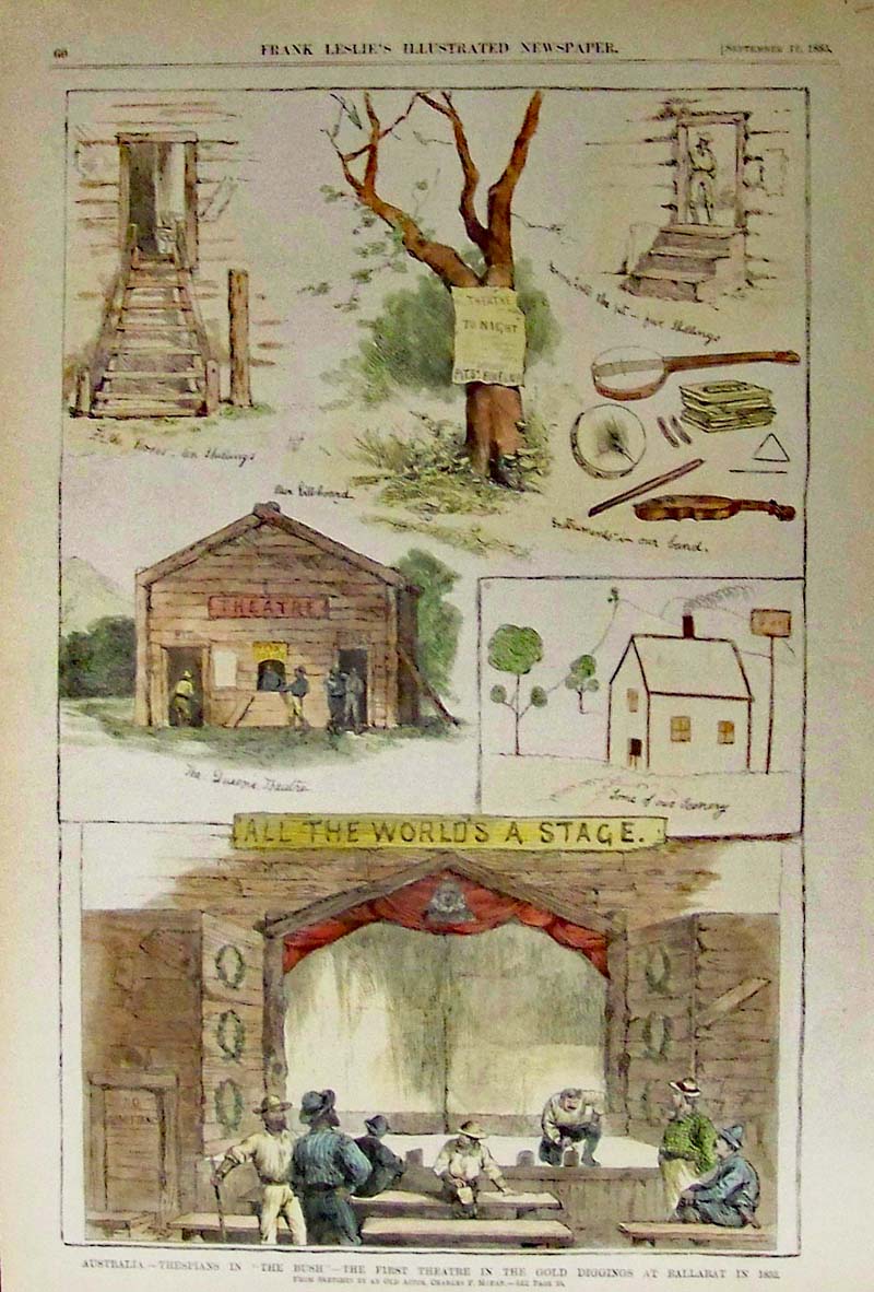
025aus: 1885 Thespians in the "Bush" Ballarat - Rare view of 1852 gold diggings first theatre, after sketches by an old actor, Charles F. Moran. Hand colored wood engraving featured in Frank Leslie's Illustrated Newspaper. 16 x 11 in. $80 |
|||||||||
| Order Form | |||||||||||
| Back to Homepage | |||||||||||