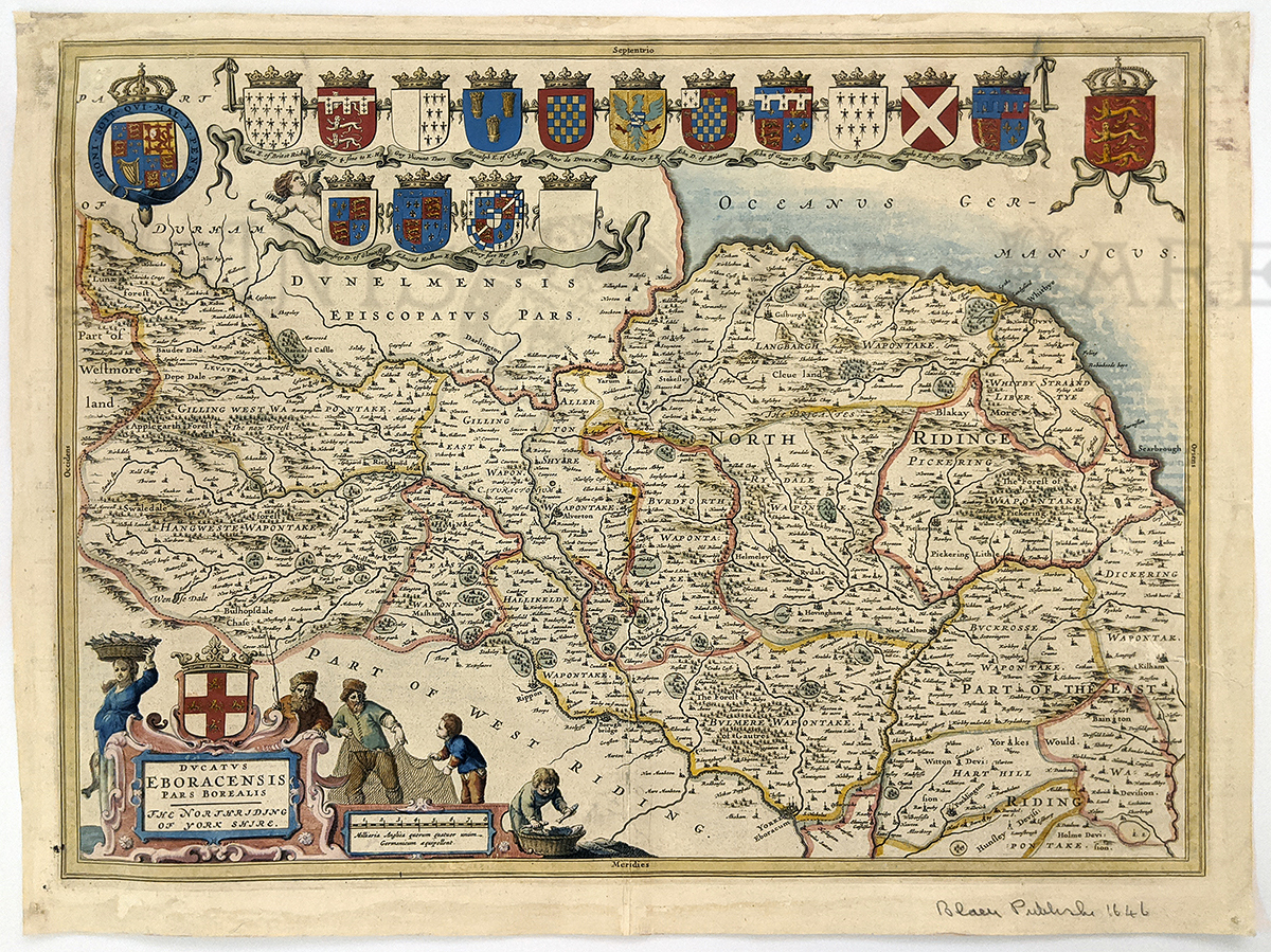
000eng:
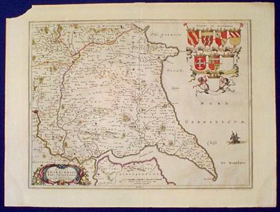
1646 Rare Yorkshire by Johannes Blaeu map titled, "Ducatus Eboracensis
Pars Borealis - The Northriding of York Shire." Decorative hand colored
map of the North Riding of Yorkshire, with a fine title cartouche of
fishing, two royal crests, thirteen family armorials and a blank
armorial.
Rare Great Britain map.
19-1/2 x 15 in. $900
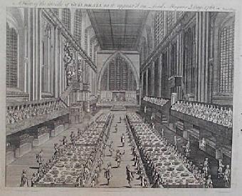
002eng:
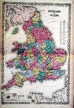
1761 View of Guildhall. Antique copper engraving
shows the interior of Guildhall, as it appeared on Lord Mayors Day in
1761. 8x10 in. $50
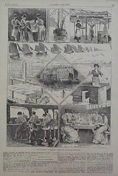
003eng:
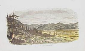
1880 Sardine Fishery Scene in Cornwall, England.
Antique wood engraving published in an 1880 issue of Harper's Weekly
shows several exterior and interior scenes in the sardine fishery in
Cornwall, England. Accompanied by text. 11x16 in. $30
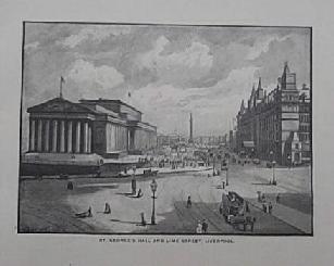
004eng:
1892 St. George's Hall and Line Street, Liverpool, England. Rare wood
engraving published as an illustration to a book in 1892 shows St.
George's Hall and Lime Street in Liverpool, England. Attractive print.
8x11 in. $30
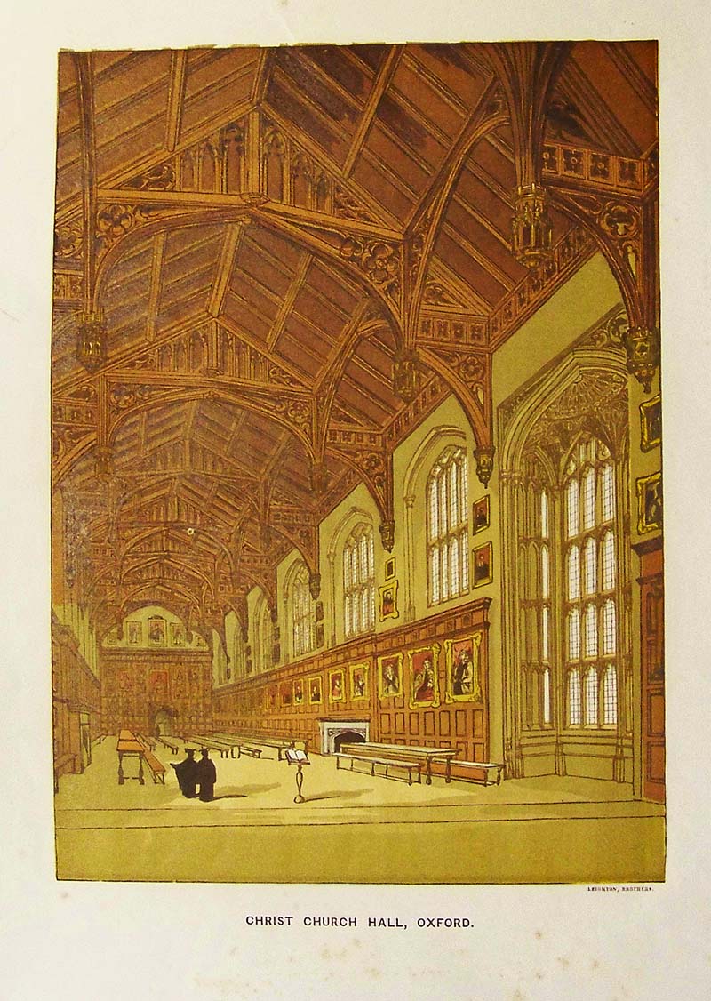
005eng:
C.1880 Color image of the inside of Christ Church Hall in
Oxford, England.
12 x 8-1/2 in. $40
006eng:
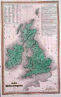
1837 French Map of the British Isles. Hand-colored engraved French map
of the British Isles was published in 1837. The map shows provinces,
towns, cities and geographical details. A table of statistic apears in
French on the right hand corner. 10x16 in. $60
007eng:
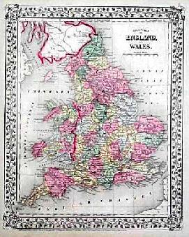
1867 Old Mitchell Map of England and Wales.
Handsome, color map of England and Wales was published in 1867 by S.
Augustus Mitchell. The map shows counties by color, towns, cities,
railways lines and geographical details. Accompanied by the signature
Mitchell
decorative border.
10x15 in. $40
008eng:
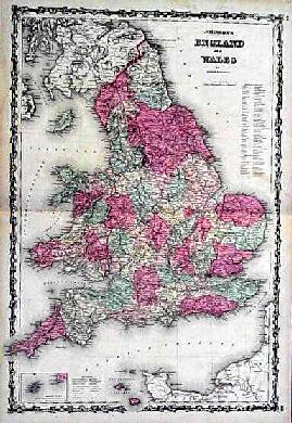
1860 Johnson's Map of England and Wales. Large, color
map of England and Wales was published in 1860 by Johnson and Browning.
Map shows the counties in Wales and England, differentiated by color
and listed in a key in the right-hand margin. Attractive map shows
geographical details, cities, towns, railways, common roads, canals,
and battlefields. Map also shows smaller inset map of the Scilly Isles.
18x26 in. $50
009eng:
1856 Colton Map of England and Wales. Large, color
map of England and Wales was published in 1856 by JH Colton and
Company. Map shows the counties in Wales and England, differentiated by
color and listed in a key in the right margin. Handsome map shows
geographical details, towns and villages, capitals, railroads, canals,
roads and battlefields. 18x28 in. $70
010eng:
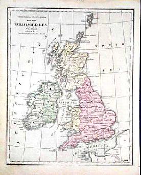
1873 Map of the British Isles. Color map of the British Isles was
published in 1873 by the Colton Company for a school textbook. Map
shows major cities, towns, waterways of Ireland, Scotland, England,
Whales and the Shetland Islands. 9x12 in. $40
011eng:
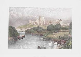
1860 View of Windsor Castle. Beautiful, color steel engraving published
as an illustration to a book in 1860. It shows a picturesque view of an
impressive Windsor Castle. 10x12 in. $50
013eng:
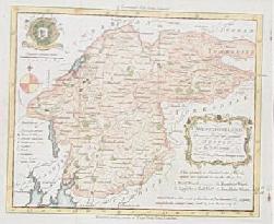
1761 Map of Westmoreland. Color, copper engraved
map of Westmoreland was published in 1761 as an illustration to a book.
It shows towns, villages, churches, castles, parks, inns and roads. The
map also shows four wards. Rare, collectible print, 8x10 in. $80
015eng:
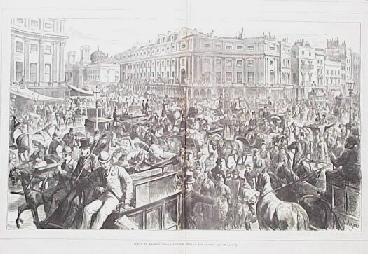
1875 Regent Circus Scene. Large, wood engraving
published in an 1875 issue of Harper's Weekly shows a crowd gathered in
Regent Circus, London. Lovely detailed engraving. 16x22 in. $50
016eng:
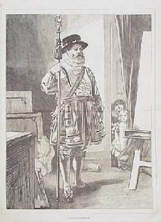
1878 Beef-Eater Print. Wood engraving published in an
1878 issue of Harper's Weekly shows a beef-eater standing at attention
as children look on. 11x16 in. $30
017eng:
1869 House of Commons Interior. Large, wood engraving
published in an 1869 issue of Harper's Weekly shows an interior scene
in the House of Commons. The title is "The Lobby of the House of
Commons."
16x22 in. $50
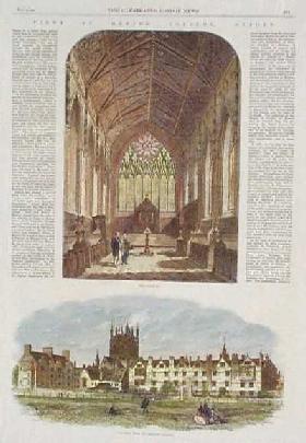 018eng: 018eng:
1864 Views: Merton College, Oxford England. Two hand colored, engraved
views of Merton College: 1) The interior of the chapel; and 2) a
general view of the college grounds. On either side of the top image is
part of an article describing the college and its history.
11x16 in. $40
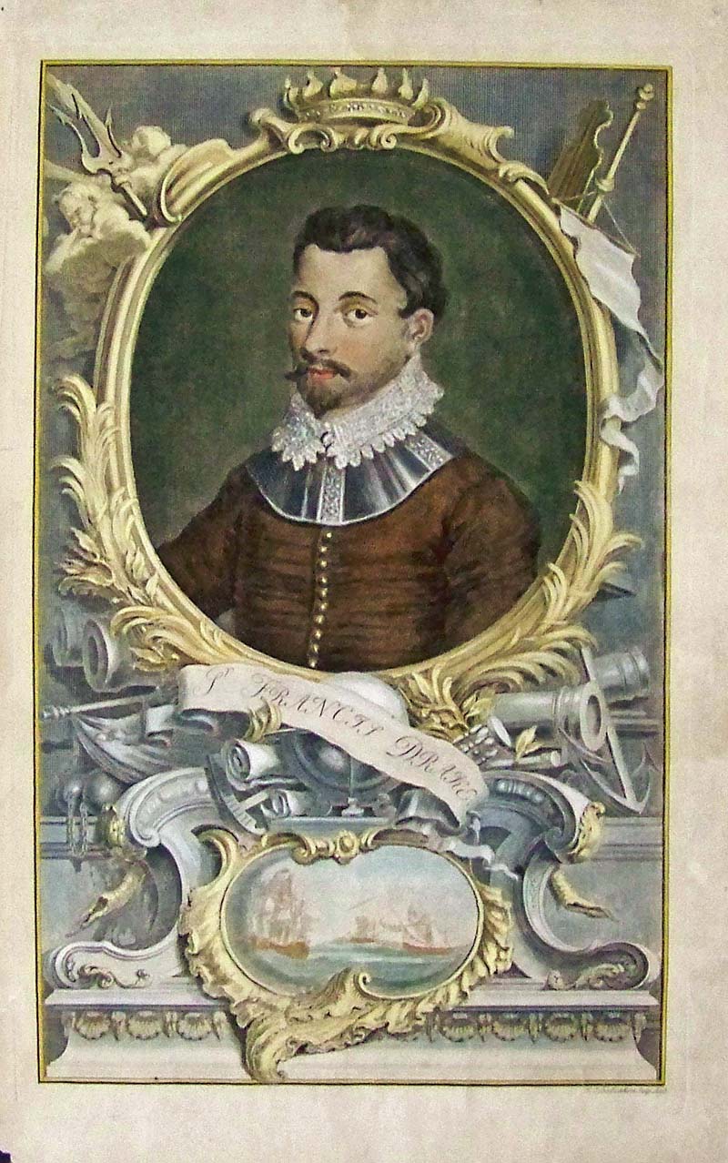
206nav:
1744 Sir Francis Drake - This is a very old, spectacular hand colored
copper engraving showing an ornate portrait of Sir Francis Drake as a
young man and a battle scene below.
16 x 10 in. $150
|
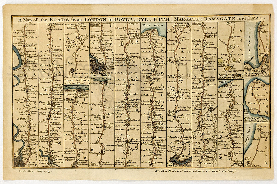
019eng:
1765 Strip Map of Roads from London England . Interesting hand colored
"strip" road map from the May 1765 issue of Gentleman's Magazine. Shows
the roads from London to five other English cities: Dover, Rye, Hith,
Margate, Ramsgate and Deal. Small towns and geographical features along
the roads are all shown.
8x12 in. $80
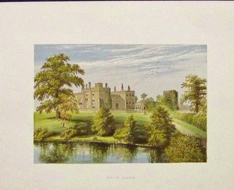
020eng:
C.1880 Chromolithograph showing Ripley Castle, a 14th-century country
house in Ripley, North
Yorkshire, England.
10-1/2 x 8-1/2 in. $40
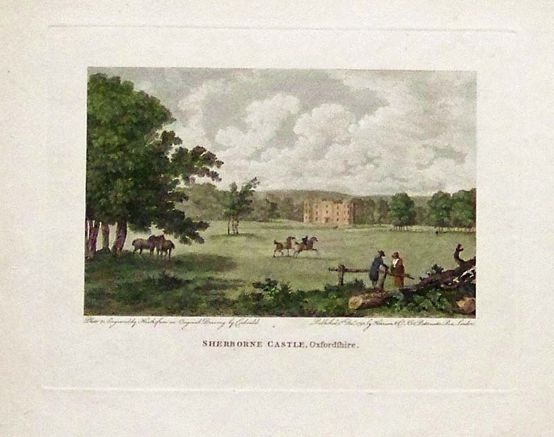
021eng:
1792 Hand colored steel engraving showing the Sherborne Castle,
Oxfordshire. Published by Harrison & Co., Paternoster Row,
London.
10 x 8 in. $60
022eng:
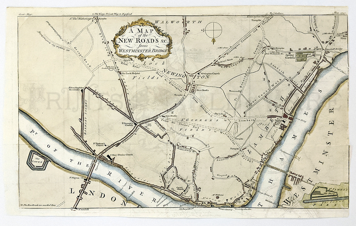
An engraved and original hand colored map of London’s Newington area,
showing the road system south of the Thames River, oriented south at
the top and extends from the London Bridge and Tower, Westminster north
to Kensington Common. A very decorative title cartouche at top center,
also shows proposed road to Kent, St Georges Field, St James Park is
shown in green lower right. Condition: Good, small margins, right
margin missing, six folds visible but
hardly noticeable.
size 14 x 8.75 image
$200
023eng:
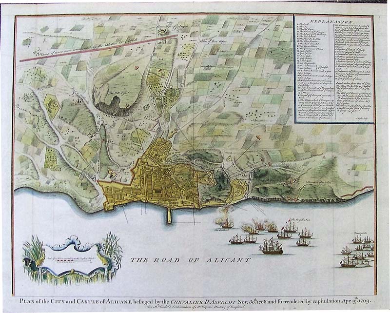
A Plan of Alicante Basire, 1740 - A wonderful original hand colored
copper engraved Plan of the City & Castle of Alicante, as
besieged by the Chevalier d' Asfeldt Nov. 30th 1708 &
surrendered by capitulation April 19th 1709.'' For Mr. Tindal's
Continuation of Mr. Rapin's History of England.' by J. Basire. An
elevated view showing the city & castle of Alicante, with
surrounding roads & countryside, & showing warships in
harbor firing on the town, with 'The Dunkirk' & 'The Royall
Anne' indicated. Very detailed table of explanation to top right
indicating gates, prominent buildings, the mine, batteries, trenches
etc. Condition: Excellent with many old folds slightly visible, small
top and bottom margins with nice brilliant color throughout.
size 18.7 x 16.2 image
$600
024eng:
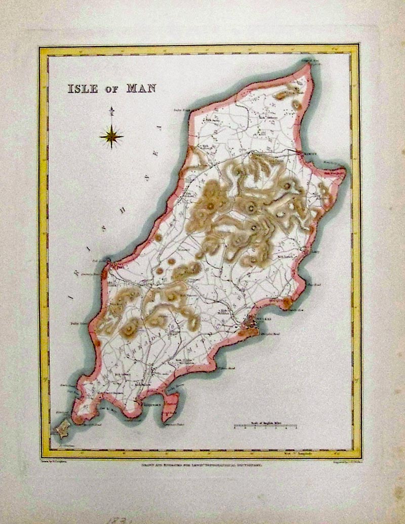
1831 Isle of Man - Hand colored copper engraving.
9-1/2 x 7-1/4 in. $75
200eng:
1667
Blaeu Map: Yorkshire England. Beautiful map from Baleu's 1667 Atlas
Major, showing the East Riding of Yorkshire in England. Title of the
map is "Ducatus Eboracensis, Pars Orientalis." Decorative frame of the
map title is in the North Sea. Eight shields show the coats of arms of
the Earls of Holderness (with two shields empty). Original outline hand
coloring on the county borders. Woods are shown as individual trees,
and towns are drawn as small buildings. The city of York is on the far
left side of the map image. This map is in excellent condition, with no
stains or tears on the map image. There is a small piece torn from the
upper left corner of the margin, which could easily be covered by
matting and framing.
18x24 in. $550
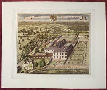
201eng:
1719 English Country Scene: Manor House. Beautiful,
hand-colored scene from Dr. Harris's History of Kent, drawn by Harris
in the style of Kip's views. Printed in 1719. Title of the scene is
"Wierton, the Seat of Sr. Christopher Powell Bart." Image is surrounded
by a beautiful French mat. Not framed. Image size is 15x17 in. Mat size
is 21x24 in. $300
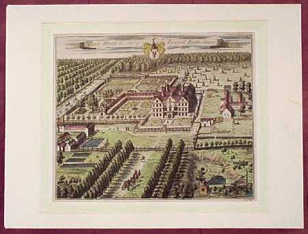
202eng:
1719 English Countryside Birds Eye View by Kip.
Beautiful, hand-colored scene from Dr. Harris's History of Kent, drawn
by Kip. Printed in 1719. Title of the scene is "Oxen Hoath, the Seat of
Leonard Bartholmew Esq." Image is surrounded by a beautiful French mat.
Not framed. Image size is 14x16 in. Mat size is 18x24 in. $300
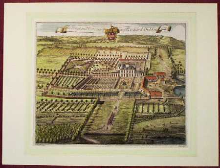
203eng:
1719 English Country Scene by Kip. Beautiful,
hand-colored scene from Dr. Harris's History of Kent, drawn by Kip.
Printed in 1719. Title of the scene is "Aldington West Court, ye Seat
of Richard Sheldon Esq." Image is surrounded by a beautiful French mat.
Not framed. Image size is 14x16 in. Mat size is 18x24 in. $300
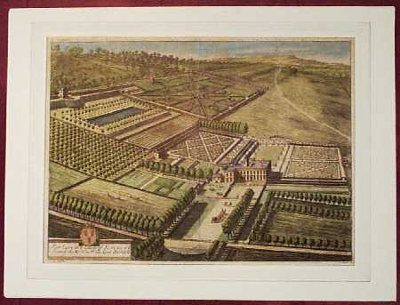
204eng:
1719 English Countryside View by Kip. Beautiful,
hand-colored scene from Dr. Harris's History of Kent, drawn by Kip.
Printed in 1719. Title of the scene is "Fair Lawn in ye County of Kent,
one of ye Seats of the Rt. Honble. the Lord Barnard." Image is
surrounded by a beautiful French mat. Not framed. Image size is 14x19
in. Mat size is 18x24 in. $300
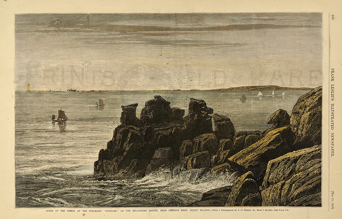
207eng:
Scene of the wreck of the steamship "Schiller" on the Retarriere
Ledges, near Bishop's Rock, Scilly Islands. Very nice hand colored wood
engraving from the May 29, 1875 issue of Frank Leslie's Illustrated
Newspaper. 11x16 in. $50
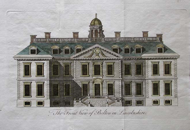
209eng:
Very nice hand colored copper engraving from 1771. Image titled, The
Front View of Belton in Lincolnshire. This print is in excellent
condition, and would look great in a frame. 8x11 in. $60
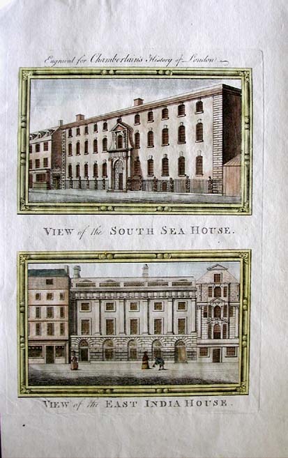
210eng:
Very nice hand colored copper engraving from c1750. Two images engraved
for Chamberlain's History of London. Upper image titled, View of the
South Sea House. Lower image titled, View of the East India House.
8.5x14 in. $60

211eng:
Hand colored copper engraving, engraved for
Chamberlain's History of London c1750. Three views of buildings on
Lombard Street. Left image titled, View of St Edmond the King Lombard
Street. Center image titled, View of Alhallows Lombard Street. Right
image titled, View of St Mary Woolnorth Lombard Street. 8x11.5 in. $60
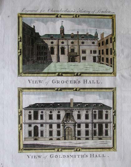
212eng:
Beautiful hand colored copper engraving was published
c1750 for the Chamberlain's History of London. Upper image is
captioned, View of Grocer's Hall. Lower image is captioned, View of
Goldsmith's Hall. Small archival repairs in left margain, and on lower
section of the top image. 8.5x11 in. $60
213eng:
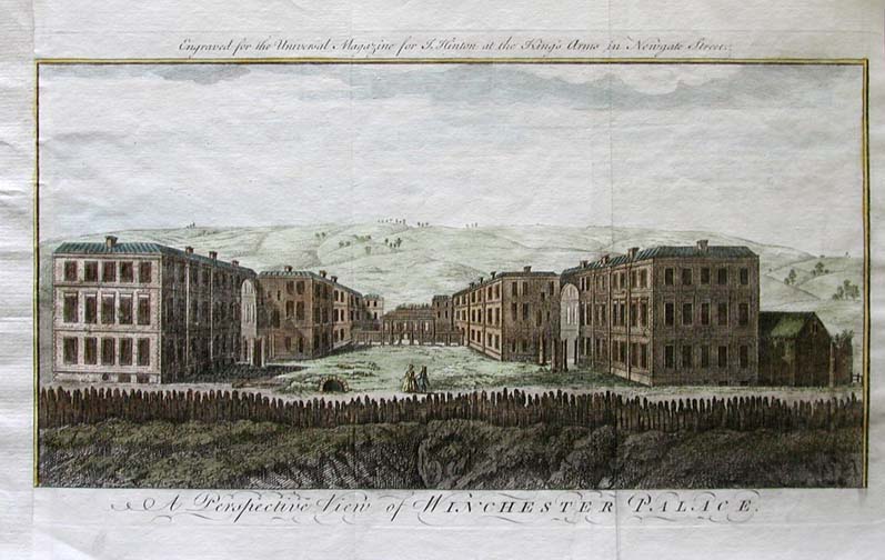
This hand colored copper engraving from circa 1750 is
titled, "A Perspective View of WINCHESTER PALACE". It was engraved for
the Universal Magazine and for Hinton at the King's Arms in Newgate
Street. Left margain has been archivally repaired. 7.5x12 in. $60
 214eng: 214eng:
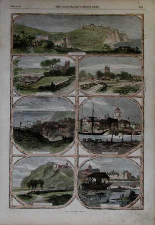
Hand colored wood engraving from the September 7,
1861 issue of The Illustrated London News. Page titled The Cinque
Ports, contains seven views. Larger top image of Dover, with smaller
images below of Hythe, Romney, Hastings, Sandwich, Winchelsea, and Rye.
11x16 $50
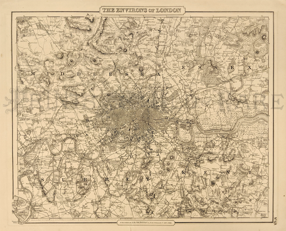
|
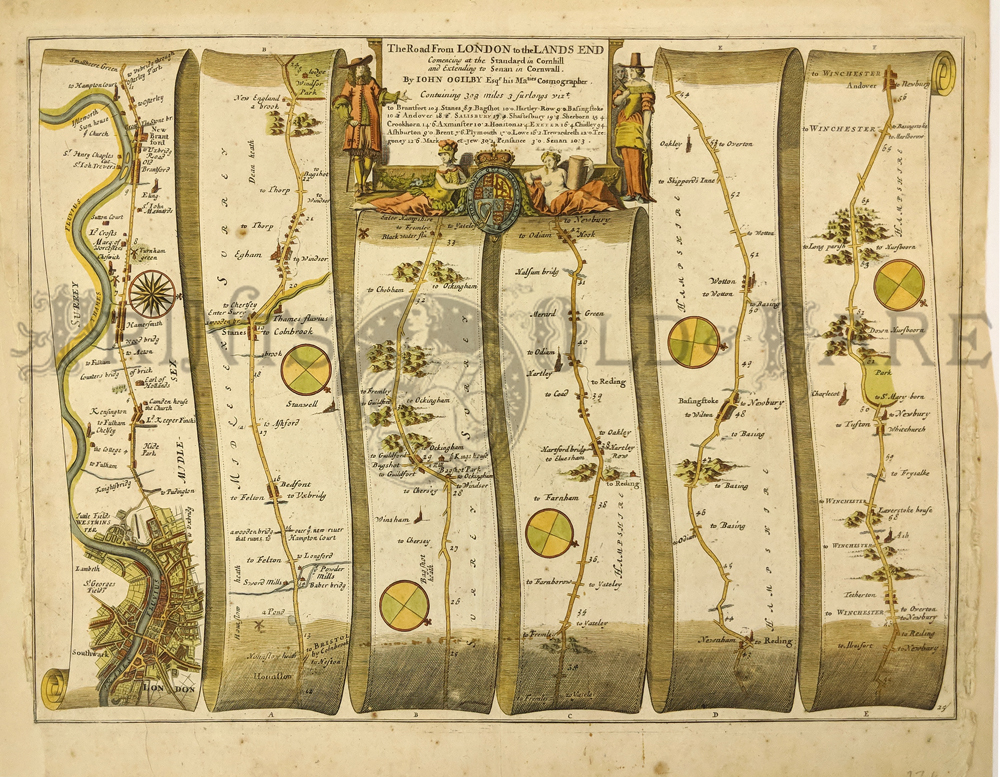
227eng:
Road Map – London to Land’s End by John Ogilby (1675) Hand colored,
copper engraving. Commencing at the Standard in Cornhill and extending
to Winchester. Worn lower side margins have been added – not affecting
image.
13 ½ x 18 ½ in. $250
230eng:
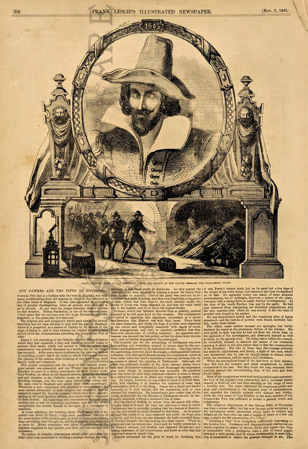
Guy Fawkes & The Fifth of November – Portrait and long article
plus picture under Parliament. Wood engraving from U.S. Publication
Frank Leslie’s 1857.
11 x 16 in. $45
231eng:
1855 Antique Map ofLondon. Handsome detailed map of London published by
J.H. Colton and Company.
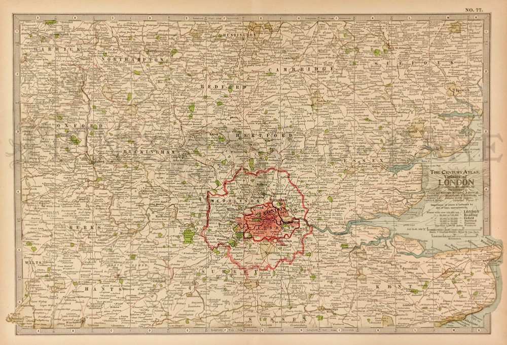
14x17 in. $80
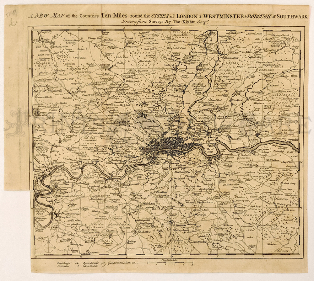
232eng:
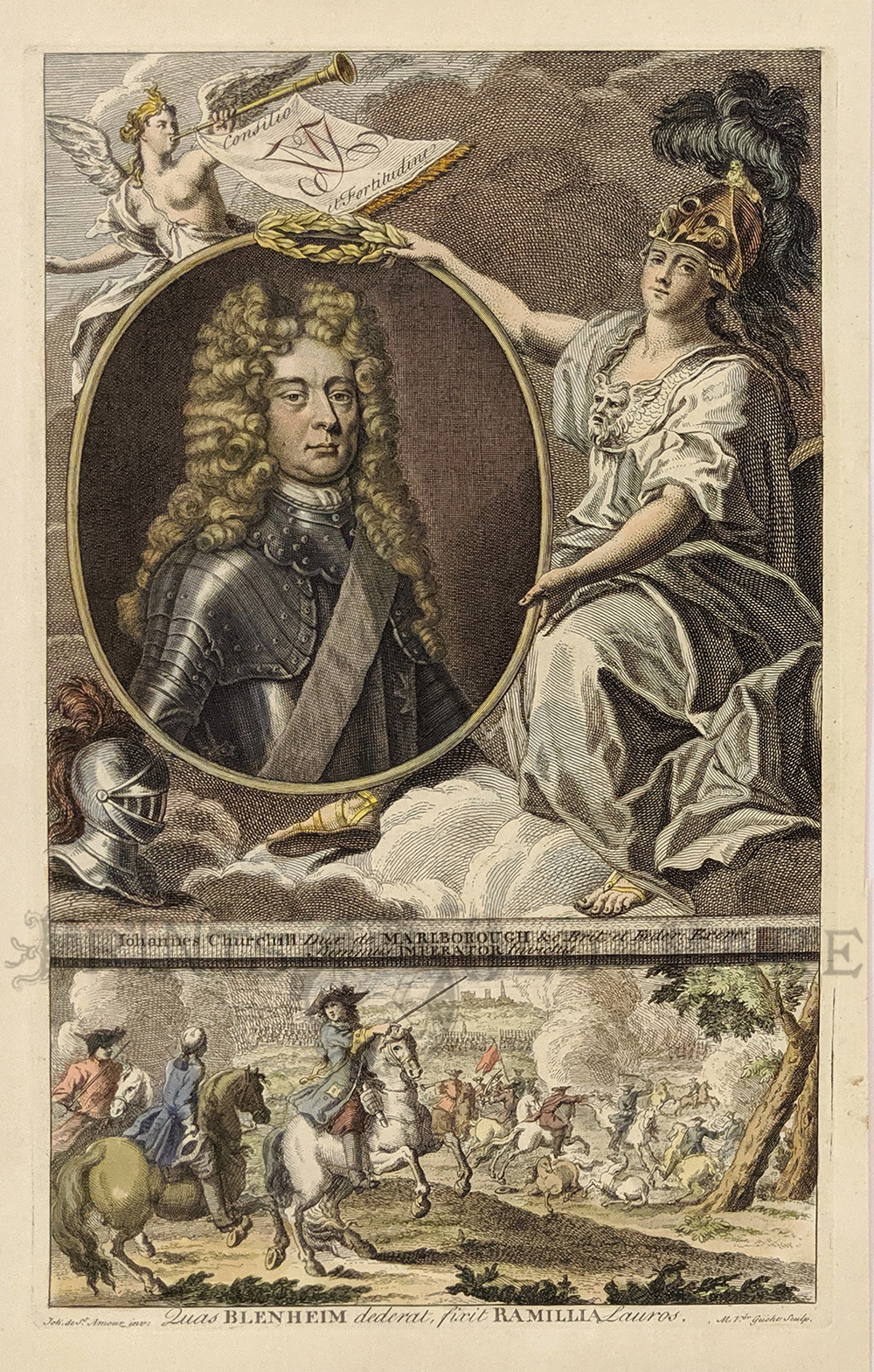
1911 Old Map of London. Attractive color map published by Century. Map
shows London and its
vicinity.
11x16 in. $30
233eng:
1797 Rare Thomas KitchinLondon Map. 200 year-old, copper engraved map
shows the cities of
London, Westminster, Borrough of Southwark and surrounding areas.
Excellent condition.
11x12 in. $150
234eng:
1784 COPPER ENGRAVING -
JOHN CHURCHILL. Stunning very old hand colored French copper engraved
portrait. "Johannes Churchill," Britain's Duke of Marlborough and
patriarch of the Churchill family which included the future Prime
Minister, Winston Churchill. Lower engraving shows Churchill leading
the charge at Blenheim. An excellent antique print, plate marks still
evident around image.
8-1/2" x 14" $120
235eng:
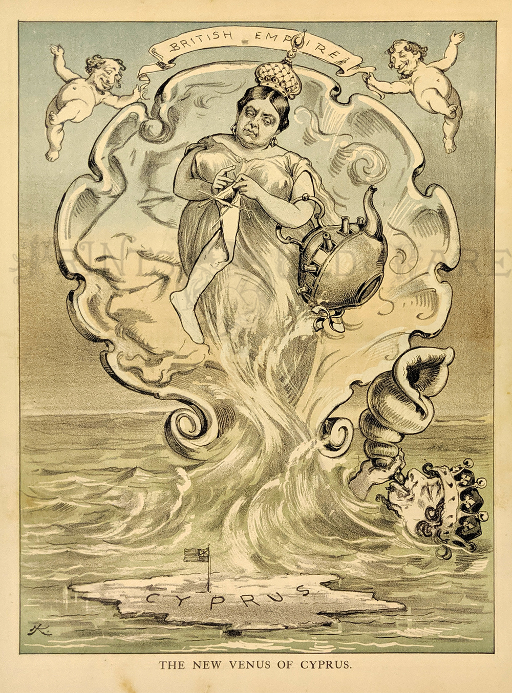
"The New Venus of Cyprus." 1878 Puck Magazine depicting the celebration
of the British Empire's growth and the newest member Cypress Island.
Chromolithograph.
9 1/2 x 13 1/2 in. $60
236eng:
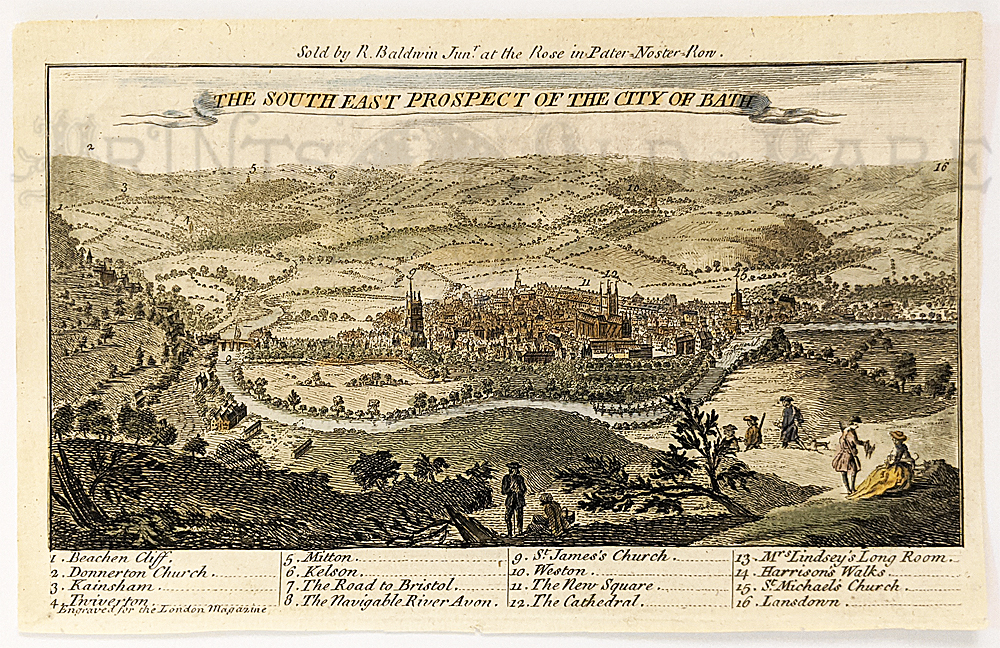
Bath 1794, birdseye view, "The South
East Prospect of the City of Bath." Hand colored copper engraving. A
key to 16 locations is included at bottom of the engraving.
5 x 8 in. $95
237eng:
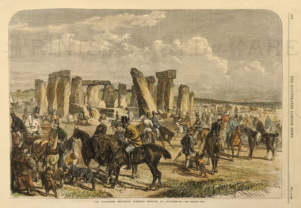
Stonehenge 1865. Lively horseback activity during a coursing meeting.
Hand colored, wood engraving.
10 ¼ x 15 ½ in. $50

239eng:
Bartholomew's Plan Of London - Central Area - c.1928. Showing major
landmarks, stations, streets, parks and various places of interest.
23 x 34 in. $150
215eng:
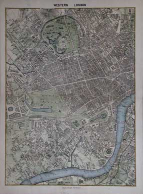
Western London. Very nice hand colored engraved map of the Western
Portion of London. Published c1850 by Charles Knight. Shows detailed
streets of Westminster and surrounding area. Includes Regents Park,
Hyde Park, Chelsea Reach, and Lambeth Reach. 14x10 in. $60
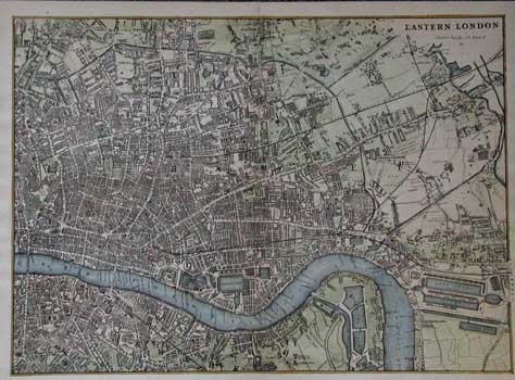
216eng:
Eastern London. Very nice hand colored map of the
Eastern Portion of London. Engraving published c1850 by Charles Knight.
10x14 in. $50
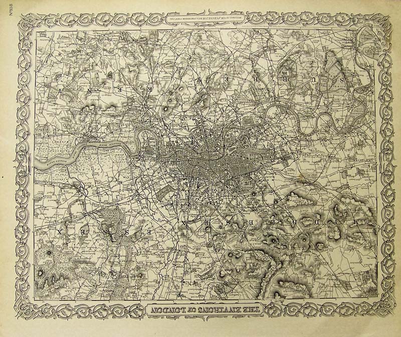
217eng:
The Environs of London, Colton, 1865. Very detailed map of Victorian
London showing all streets, roadways, rivers, significant public and
private buildings. The first plan of the London area to appear in an
American Atlas, the sections Surrey, Kent, Middlesex, and Essex are all
shown along with Colton's very attractive spiral motif border.
Condition: Very good, some age coloring
outside margin edges.
size 15.5 x 12.5 image
$300
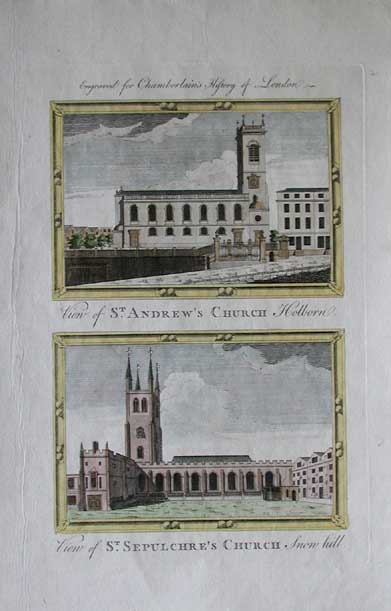
218eng:
Hand colored copper engraving from the Chamberlain's
History of London published c1750. Upper image captioned, View of St
Andrew's Church Holborn. Lower image captioned, View of St Sepulchre's
Church Snowhill. 13.5x8.5 in. $60
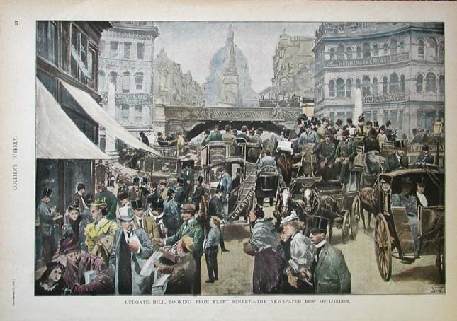
219eng:
Hand colored half tone from the September 23, 1897
issue of Collier's Weekly. Image titled, Ludgate Hill, Looking from
Fleet Street.-The Newspaper Row of London. 15x10.5 in. $40
220eng:
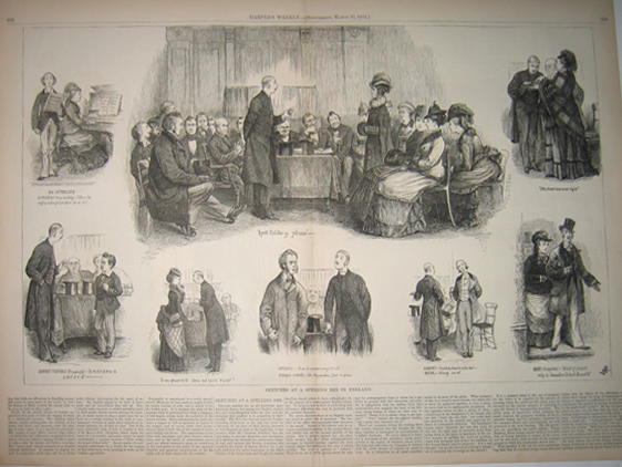
1876 Sketches At A Spelling Bee In England. Wood engraving and text
published in Harper's Weekly as a Supplement on March 25, 1876.
16x22in. $60
222eng:
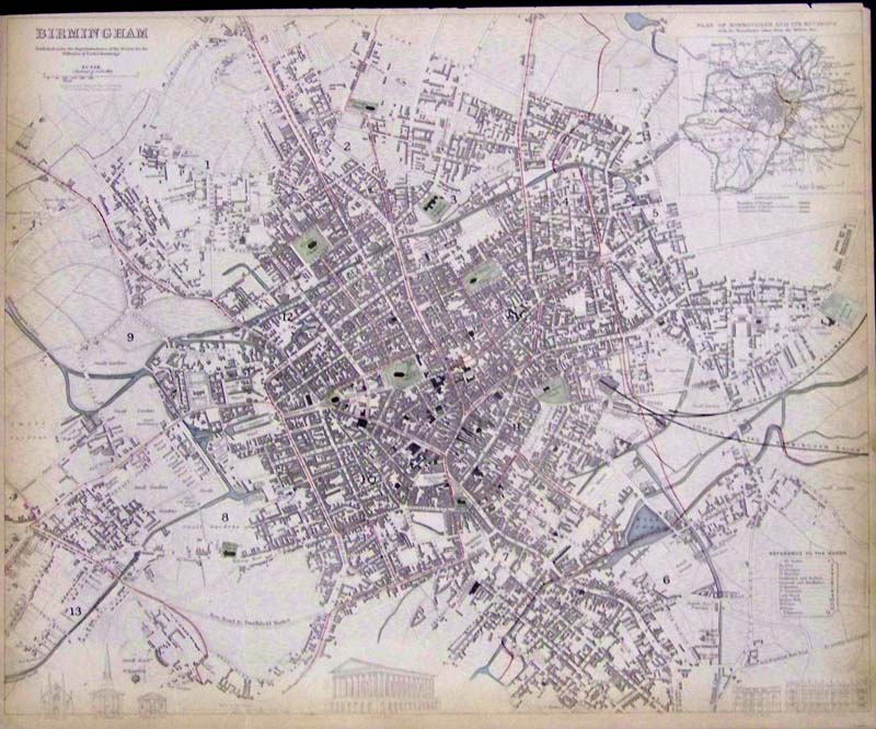
1833 Lightly hand colored steel engraved map of Birmingham, published
under the Superintendence of the Society for the Diffusion of Useful
Knowledge (S.D.U.K.). Upper righthand corner shows an inset of the Plan
of Birmingham and Its Environs, with the Boundaries Taken from the
Reform Act. Bottom left corner shows the comparison of heights of
prominent buildings and a larger Town Hall is portrayed on bottom
center. Map is in fine condition.
16 x 13-1/2 in. $175
223eng:
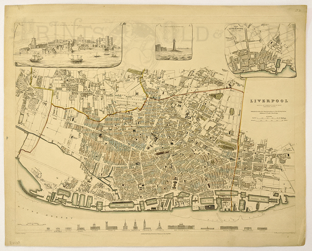
1836 Lightly hand colored steel engraved map of Liverpool, showing the
comparison of heights of prominent buildings on bottom border and the
top border shows three vignettes showing a View of Liverpool in 1729; a
lighthouse at Black Rock; and the Plan of Liverpool in the year 1729.
Published under the Superintendence of the Society for the Diffusion of
Knowledge (S.D.U.K.).
16 x 13-1/2 in. $175
224eng:
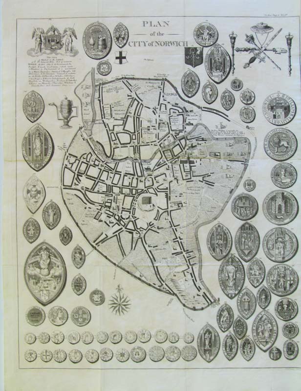
C.1770 Plan of the City of Norwich copper engraved map which shows the
City Scape plus its coins and medals. The city seal is in upper
lefthand corner.
25 x 19 in. $150
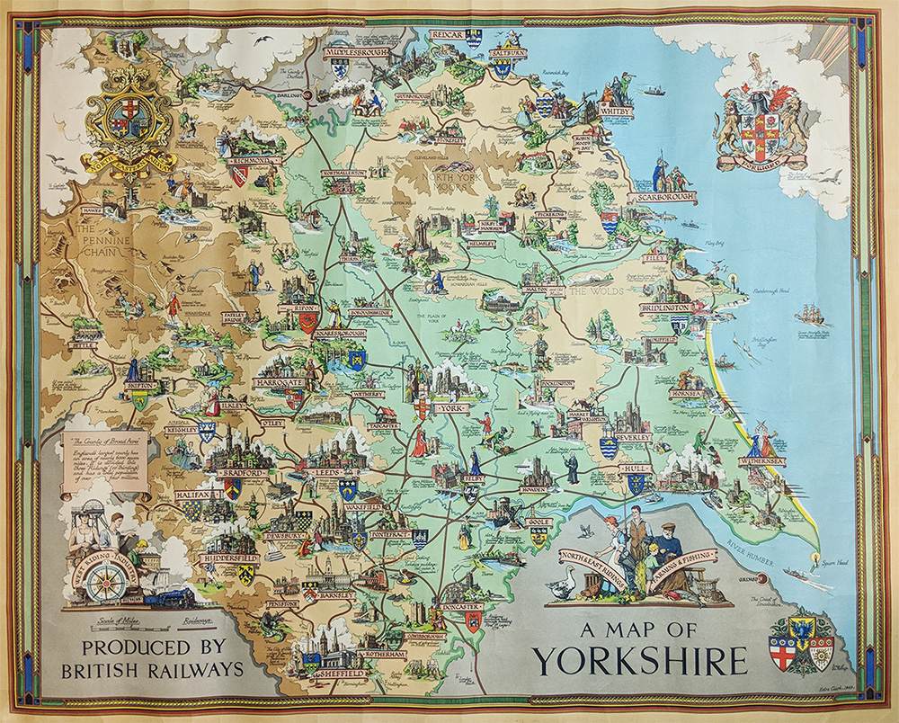
225eng:
A Map of Yorkshire. Pictorial map - Color Lithograph by Esty Clark.
Published by British Railways 1949. Features Yorkshire history
& tourist sites.
40 x 49 in. $325
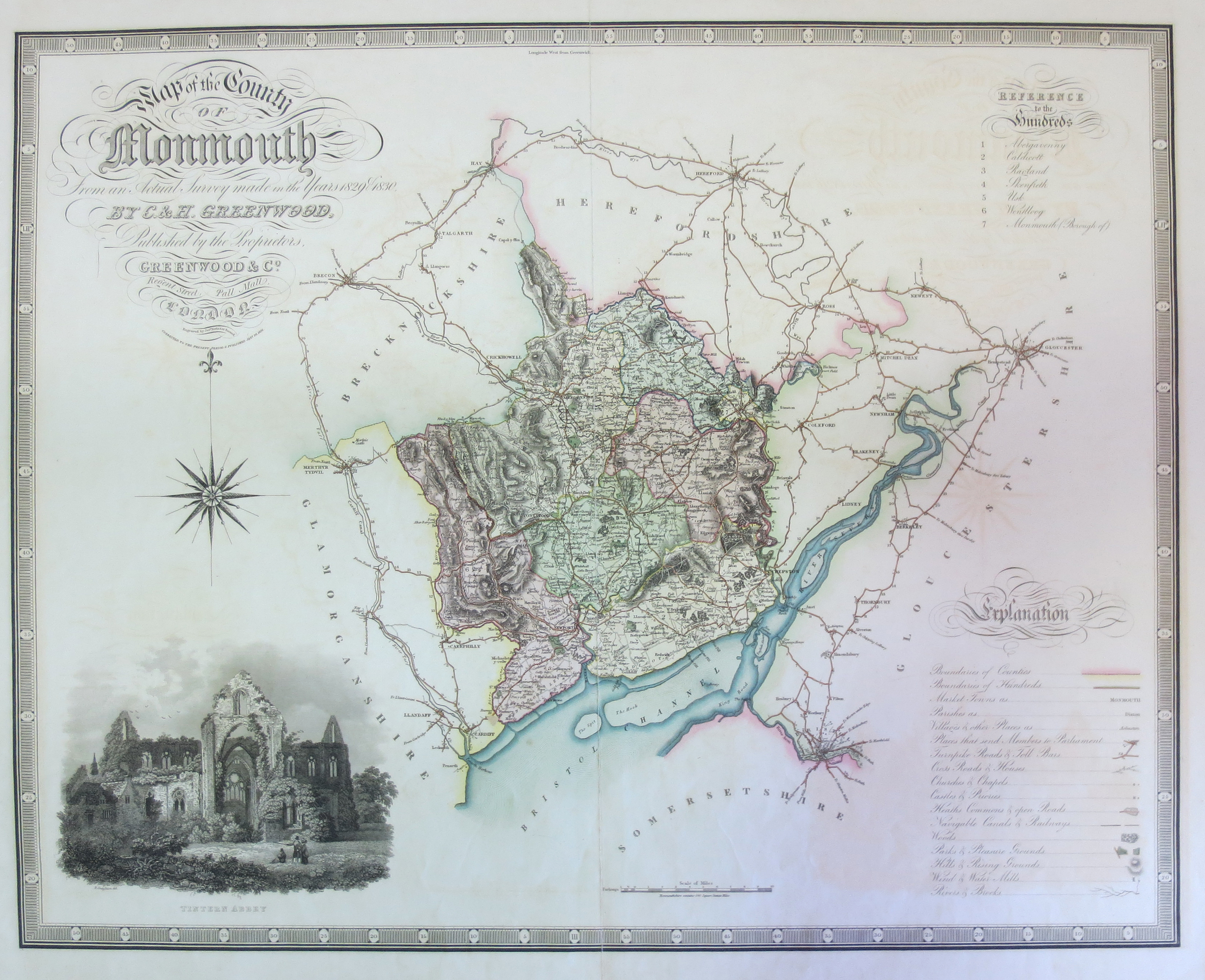
226eng:
Monmouth County - Greenwood & Co. 1830 hand colored, steel
engraved, detailed map showing roads, parishes, towns, canals, parks,
etc. Inset of Tintern Abby.
28 x 21 in. $200
|
|