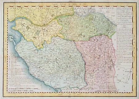
001fra:
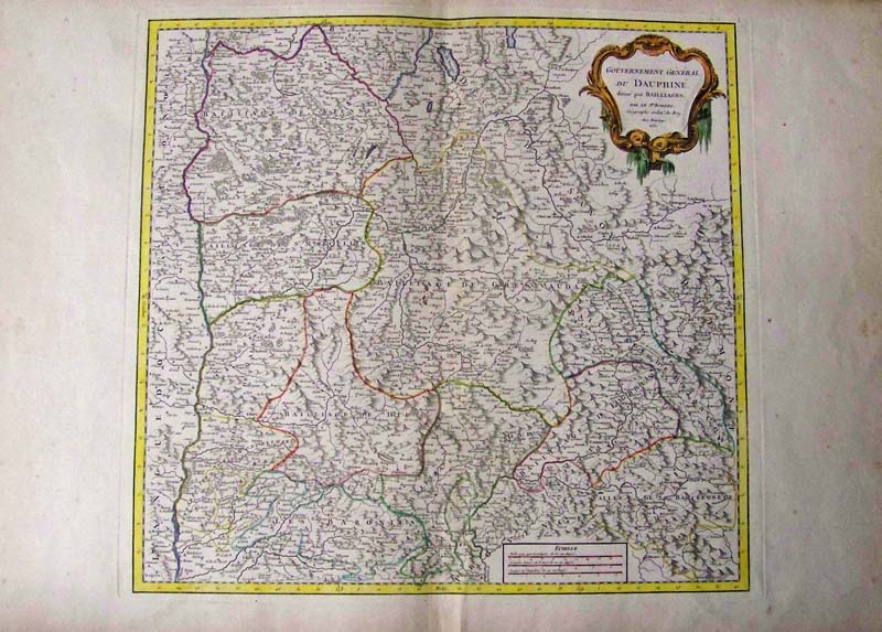
Gouvernement General Du Dauphine, Vaugondy, Gilles 1751 - A large
copper engraved and original hand colored map of the Dauphine region of
France by Robert de Vaugondy. The map covers the southeastern region of
France from Rossilon south to Guillaumes and from Privas east as far as
Susa, Italy. The map includes the whole or parts of the departments of
Drome, Isere, Savoie and hautes-Alpes and renders the entire region in
extraordinary detail offering both topographical and political
information with forests and mountains beautifully rendered in profile.
The map includes a beautifully engraved title cartouche in the top left
quadrant. This map was drawn by Robert de Vaugondy in 1751 and
published in the 1757 issue of his Atlas Universal. - Special Note:
This region, known as the playground of Europe's elite, is admired for
its stunning natural beauty, distinctive culture, superb cuisine,
delightful beaches, and fantastic wines. Isere is known for its
production of Bleu du Vercors-Sassenage, a mild cow's milk blue cheese,
and Saint-Marcellin, a softer cheese, while Drome s famous for its
production of Picodon, a spicy goats-milk cheese. The Hautes Alpes area
of France is known for its production of Coteaux and Collines
Rhodaniennes wines, and is also famous for its chestnuts.
Condition: Very Good, wide margins, normal brown aging on edges,
fold in middle.
size 19.75 x 19 image
$375
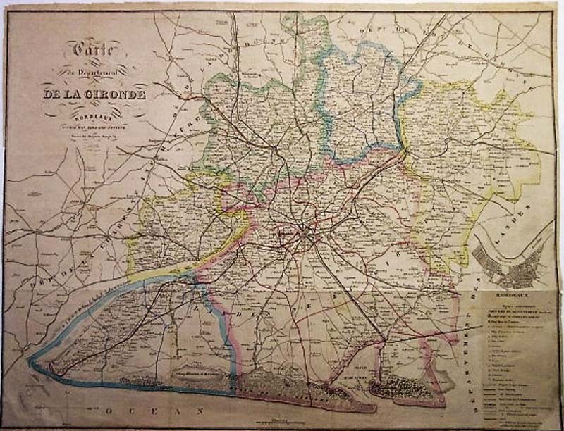
001wine:
Carte du Departement De La Gironde Bordeaux, P Chaumas, 1869 - Large
original hand colored map of the most important wine region of the
world, very well detailed showing towns, forts, major railways, roads,
(established and under construction) forges, graveyards, monuments,
inset on lower right depicts town plan of Bordeaux on the river
Garrone. Township areas of Tbourne, St Savin, Sauterre, Lusac, Langon,
Villandrant, etc. clearly delineated by colors of green, blue, rouge
and yellow, P. Chaumas, library editor. Condition: Very good, some
water spots lower left margins, and limited foxing and age coloring
throughout with light folds barely noticeable, bottom right edge torn
near legend.
size: 27.5 x 21.5
$550
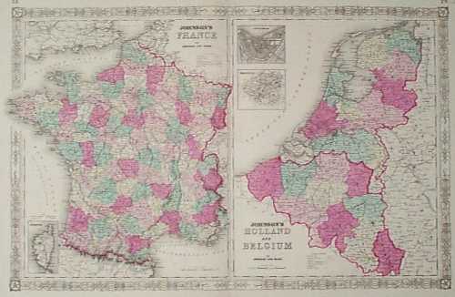
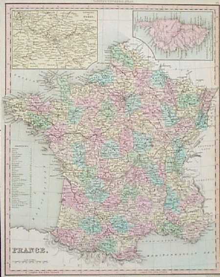
002fra:
1864 Map of France, Holland and Belgium, Published by
Johnson and Ward. Each province is individually colored with original
hand coloring. Old cities, towns, major roads, railroad lines and
geographical features are all shown. Small inset maps of Corsica,
Amsterdam and Brussels are also included. The entire image is
surrounded by a decorative border. 18x26 in. $80
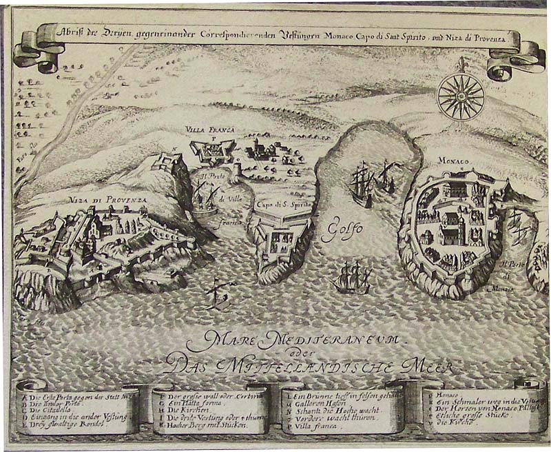
003fra:
C.1704 Monaco (Nice Provence) Abriss uncolored copper engraving of the
Mediterranean Coast by Gabriel Bodenehr in Augsburg. Map's title is,
"Abriss der Dryen gegeneinander Correspondierenden Vestungun Monaco,
Capo di Sant Spirito und Niza di Provenza."
7-1/2 x 6 in. $250
007fra:
1833 Map of France from Henry Tanner's Universal
Atlas. Beautiful antique copper engraving, with delicate original hand
color. Inset maps of Corsica and the Paris metro area are included at
top. The right margin is cut close to the map border, but the border is
completely intact.
12x15 in. $120
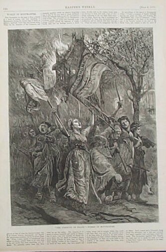
012fra:
1871 Women of Montmarte. Wood engraving shows a group of women marching
to Montmarte during the second siege of Paris. Caption reads, "The
Commune or Death!" Engraving is accompanied by text. From an 1871 issue
of Harper's Weekly. 11x16 in. $30
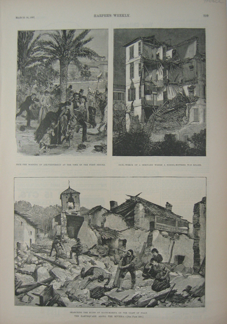
014fra:
1887 Riviera Earthquake Scene. Engraved print shows scenes of the
earthquake along the Riviera. Published in an 1887 issue of Harper's
Weekly. 11x16 in. $30
015fra:
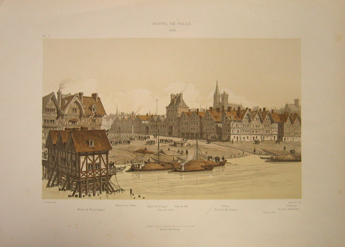
1883 View of Hotel de Ville. Beautiful lithograph
shows an exterior view of Hotel de Ville and surrounding edifices.
Image accompanied by descriptive text. Published as an illustration to
a book in 1883. 12x17 in. $50
016fra:
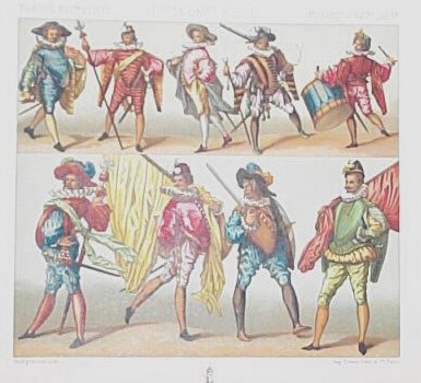
1860 French Modes Dress. Color lithograph from 1860 was
published in a book on costumes. The print shows various French modes
of dress in the 16th century. 7x8 in. $40
018fra:
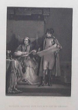
1860 Napoleon Bonaparte and Pope Pius VII. Detailed
steel engraving published circa 1860 as an illustration to a book shows
Napoleon Bonaparte inducing Pope Pius VII to sign the Concordat of
1801. This agreement re-established the Roman Catholic Church in France
and provided for the nomination of bishops by the state and the
conferral of office by the pope. 5x8 in. $40

020fra:
1870 Franco-Prussian War. Harper's Weekly wood engraving showing a
Pictorial Map of the Seat of
War in Europe.
22 x 16 in.$60
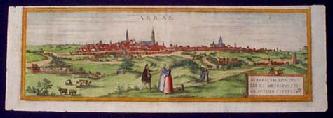
200fra:
Very Old RARE View of Arras France, 1575. This item is an hand colored,
engraved view of the town of Arras, which is near Belgium in the far
North of France. It was printed circa 1575 by Braun and Hogenberg, of
Koln, Germany. Beautiful, panoramic view of the walled town, with
figures standing and walking in the foreground. Gives the viewer a real
sense of the Northern French countryside as it looked in the mid 16th
century! Condition is excellent.
7x21 in. $400
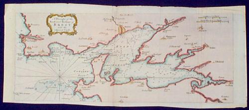
205fra:
1757 Map: Coast of Brest, France. Beautiful,
engraved map from a 1757 issue of Gentleman's Magazine, titled "A
Draught of the Road and Harbour of Brest with the Adjacent Coast."
Cities and towns along the coast are shown, and water depths off shore
are marked as well. Left margin has been extended to facilitate
framing. Overall condition is very good.
8x19 in. $60
210fra:
1815 Map: Loire River Area, Vendee France. Hand colored, engraved map
by F. Collin, published in 1815. Title is "Pays Insurge en Mars 1793,
Connu de tous Tems parses Habitans sous le Nom de Pays de Boccage."
Shows an area south of the Loire river where royalists and republicans
were in conflict during the French Revolution. Includes the city of
Nantes. Lower part of right margin is cropped, but image is not
affected. Overall condition is very good. 13x19 in. $150
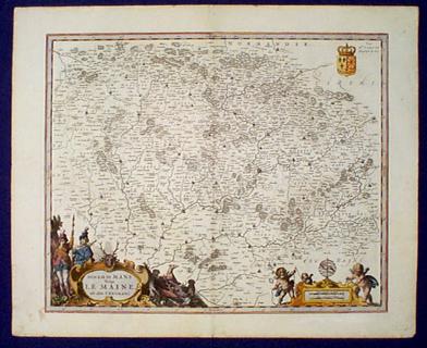
211fra:
ca.1645 Map: Le Maine, France. Beautiful, engraved map
titled "Diocese du Mans vulgo Le Maine, ubi olim Cenomani." Very
detailed and decorative. The title is surrounded by a hunting scene,
and the mileage scale is decorated with cherubs. No mapmaker's name is
given; may have been drawn by Blaeu. Area shown is between Normandy and
the Loire River. Excellent condition. 19x24 in. $650

212fra:
c.
1960s French Air Afrique poster "Les jets du soleil" "Pour decouvrir
vraiment L'Afrique Noire:" Printed by Chabrillac: Paris, Toulouse.
Poster folded. Very
good condition.
39 x 24 ½" in.
$60
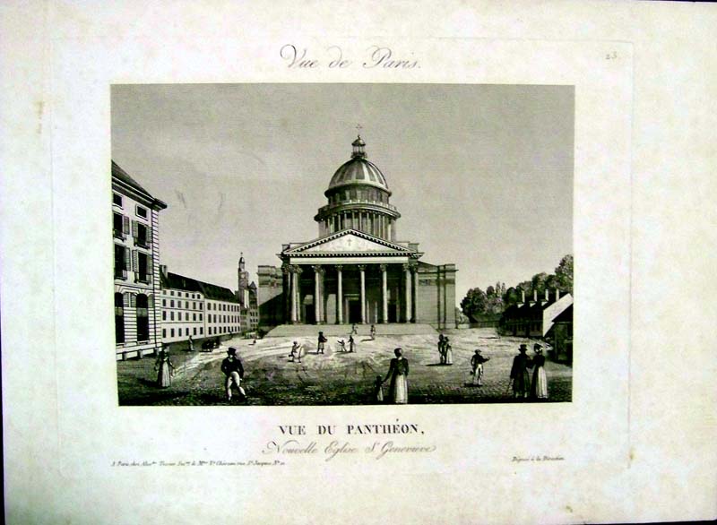
213fra:
1780 Copper engraving titled, "Vue Du Pantheon,
Nouvelle Eglise S. Genevieve." Top of engraving
shows "Vue de Paris."
14-1/2 x 11 in. $100
|
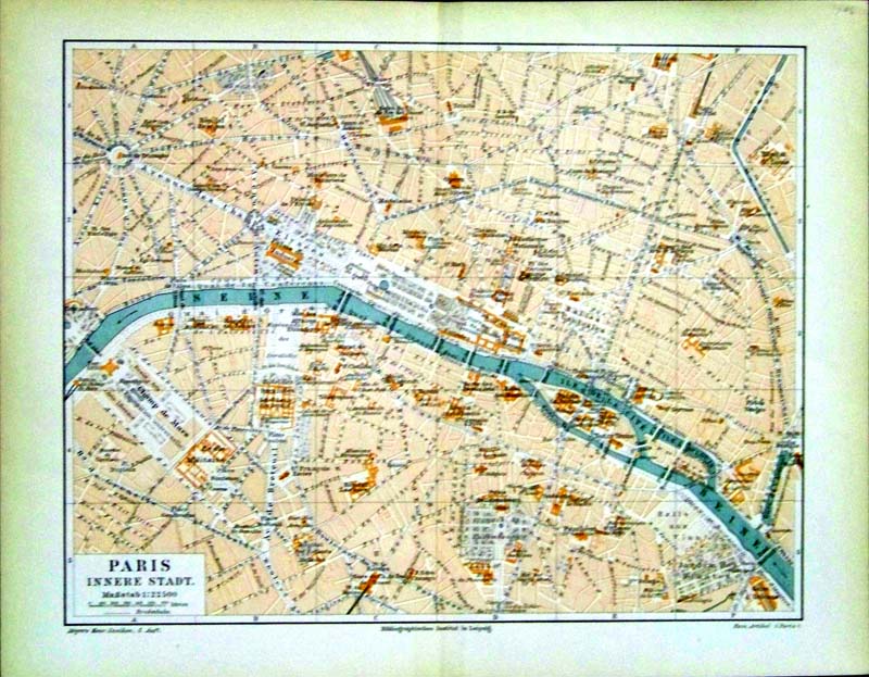
214fra:
1896 Colored lithograph map showing
Paris, Innere Stadt. Bibliographisches Institut in Leipzig is written
under bottom border. Middle of map shows the Seine running through and
branching out near Notre Dame.
12 x 9-1/2 in. $30
215fra:
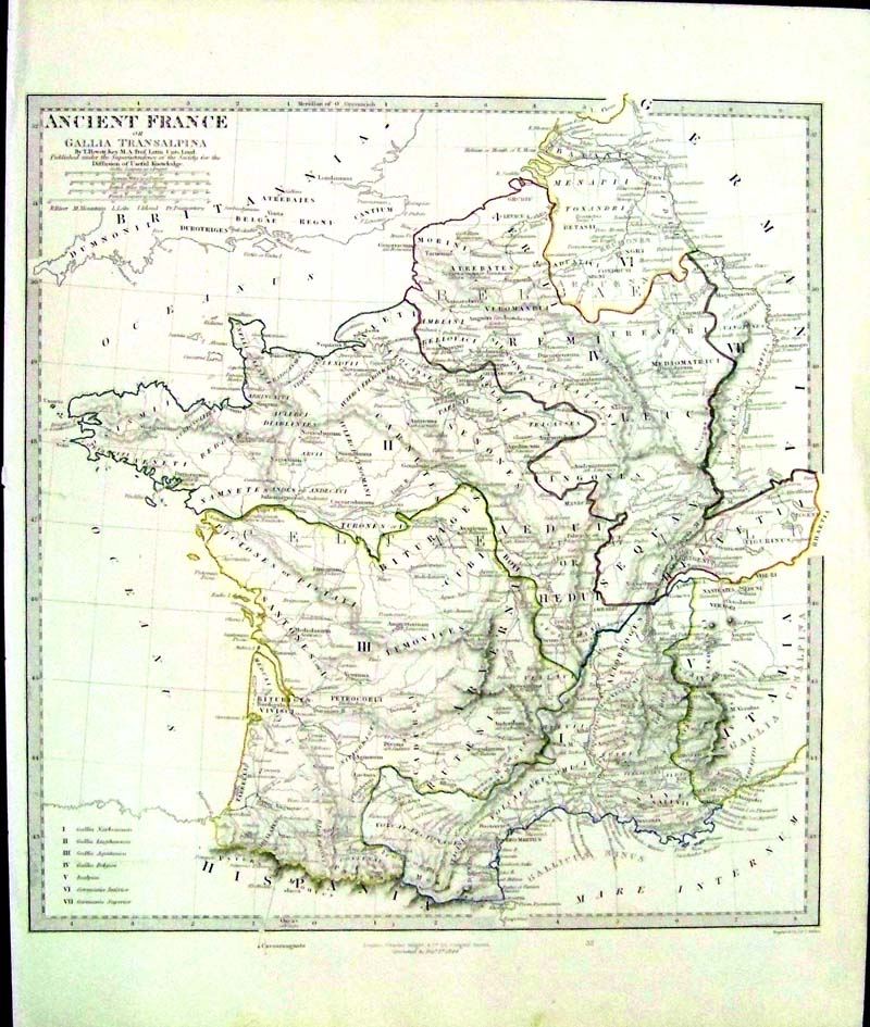
1844 Copper engraving of Ancient France
or Gallia Transalpina By T. Hewett Key, M.A. Prof. Latin Univ. Lond.,
Published under the Superintendence of the Society for the Diffusion of
Useful Knowledge. Engraved by J. & C. Walker. London, Charles
Knight & Co. Roman numerals key on bottom
lefthand corner.
17 x 14 in. $80
216fra:
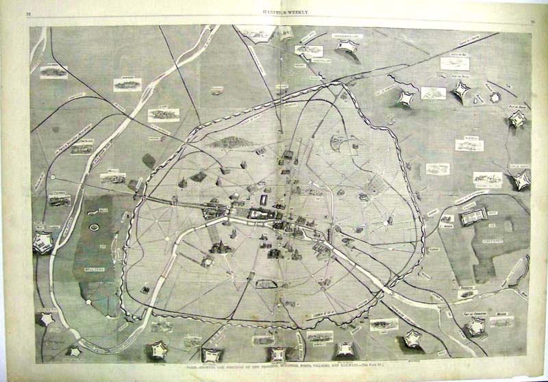
1871 Double-page wood engraving from
Harper's Weekly of Paris -- Showing the Positions of the Principal
Buildings, Forts, Villages, and Railways.
22 x 16 in. $30
217fra:
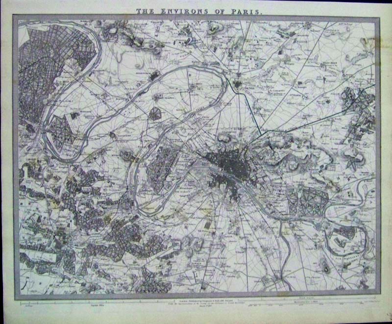
1832 Steel engraving which is lightly
hand colored and in fine condition. Title is, "The Environs of Paris."
Published by Chapman & Hall, Under the Superintendence of the
Society of the Diffusion of Useful Knowledge (S.D.U.K.), London.
16 x 13 in. $150
218fra:
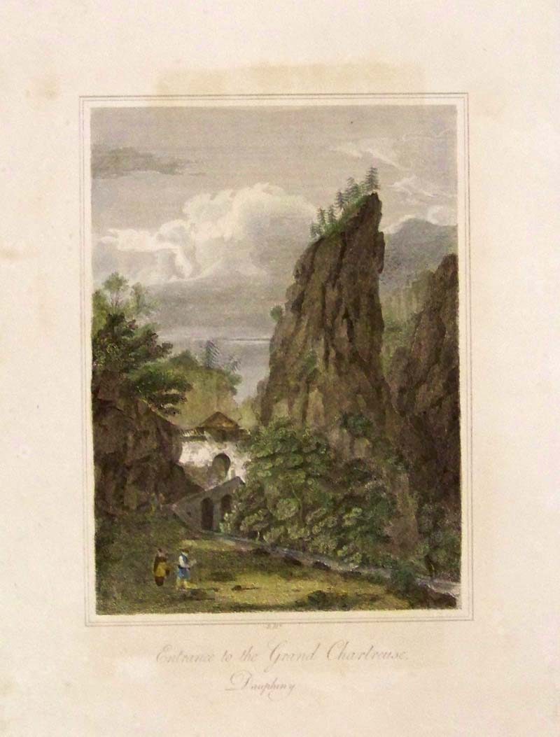
1812 Hand colored copper engraving showing the Entrance
to the Grand Chartreuse, Daupheny.
10 x 7-1/2 in. $50
219fra:
1898 Hand colored half-tone from The
Graphic showing Eiffel Tower and Ferris Wheel in background of
construction workers "Preparing for the Paris Exhibition of 1900: View
of the Building Operations from the North
Side of the Seine."
22 x 16 in. $40
220fra:
1878 Wood engraving from The Graphic
showing, "The Paris Exhibition of 1878. Seven engravings total showing
The Trocadero Building, The Pont of Jena, The Colossal Statues of Each
Nation at the Entrance of the Building, the Tramways at the Trocadero,
among other scenes.
22 x 16 in. $40
221fra:
1890 Lightly hand colored map of Paris,
France. The Champ De Mar is shown on the left and The Palais Des
Tuileries is shown
near center of map.
22 x 14 in. $35
222fra:
1877 Wood engraving from The Graphic showing "The
Forthcoming Paris Exhibition." Top engraving shows "The Principal
Facade of the Building on the Champ De Mars." Bottom engraving shows
"The Building on the Trocadero."
23 x 16 in. $50
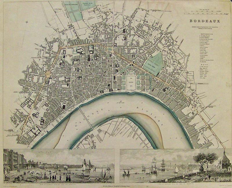
223fra:
1832 Hand colored steel engraving map of Bordeaux, France which is
lightly hand colored and in fine condition. Published under the
Superintendence of the Society for the Diffusion of Useful Knowledge
(S.D.U.K.) in London. Map is embellished with vignettes on bottom
border showing two different views of Bordeaux.
16 x 13-1/2 in. $300
224fra:
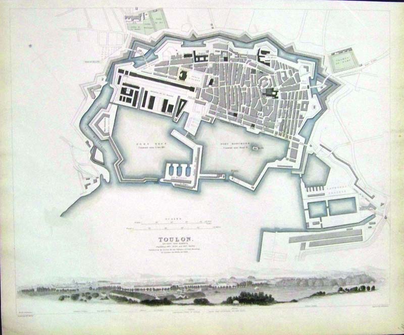
1840 Lightly hand colored steel engraving of ancient Toulon, France.
Published by the Society for the Diffusion of Useful Knowledge
(S.D.U.K.), London. Fine condition and embellished with vignette on
bottom border. Map shows population during that time.
16 x 13 in. $150
225fra:
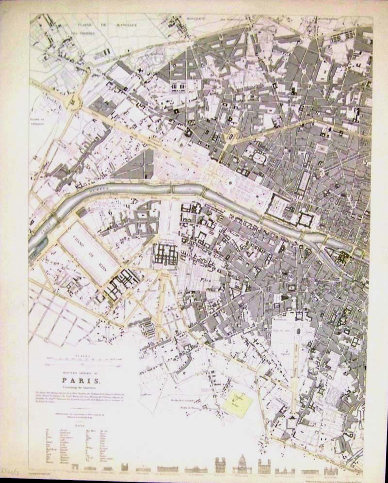
1834 Lightly hand colored steel engraved map of the
Western Division of Paris, France, Including the Quarters. Published by
the Society for the Diffusion of Useful Knowledge (S.D.U.K.), London.
Fine condition with key in bottom lefthand corner and comparison of
heights of prominent buildings on bottom border.
16 x 13 in. $150
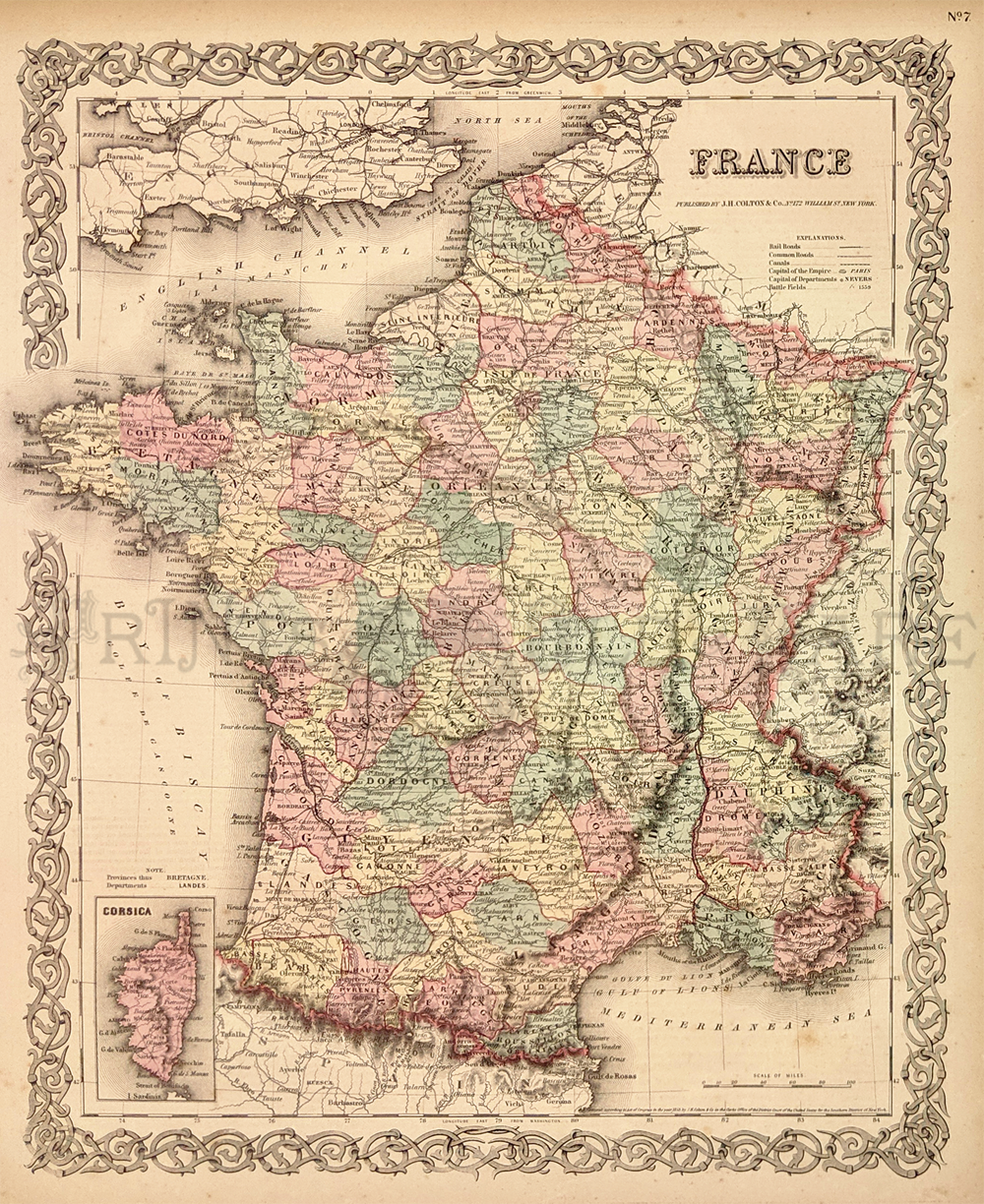
226France:
Map of France by J.H. Colton. Each province in the country is
individually hand colored. A small inset map of Corsica is in the
bottom left corner. The entire image is surrounded by a decorative
border.
17-1/2 x 14-1/2 in. $50
228fra:
C. 1850 Hand colored lithograph of the "Vue de la Bastille du cote du
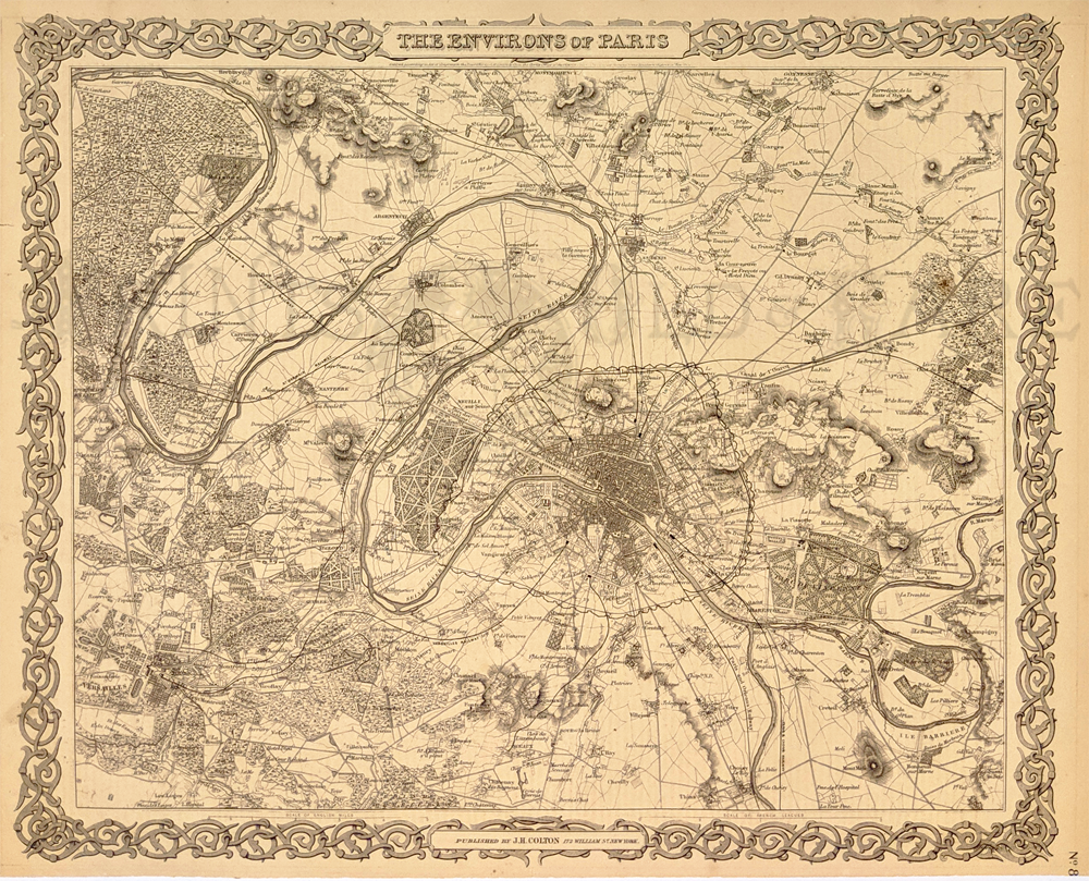
Pont-Levis." Authentic Antique Print.
11-1/2 x 8 in. $100
229fra:
1871 Supplement to Harper's Weekly wood engraving showing the Pictorial
Map of the City of Paris and it's Environs, Showing the Principal
Buildings, Monuments, Parks, Etc., the French Fortifications , and the
Prussion Lines of Investment for the Franco Prussian War. A bird's-eye
view of Paris. Image size minus borders is:
29-1/2 x 20-3/4 in. $125
230fra:
1848 Huge antique Paris engraving which shows a beautifully engraved
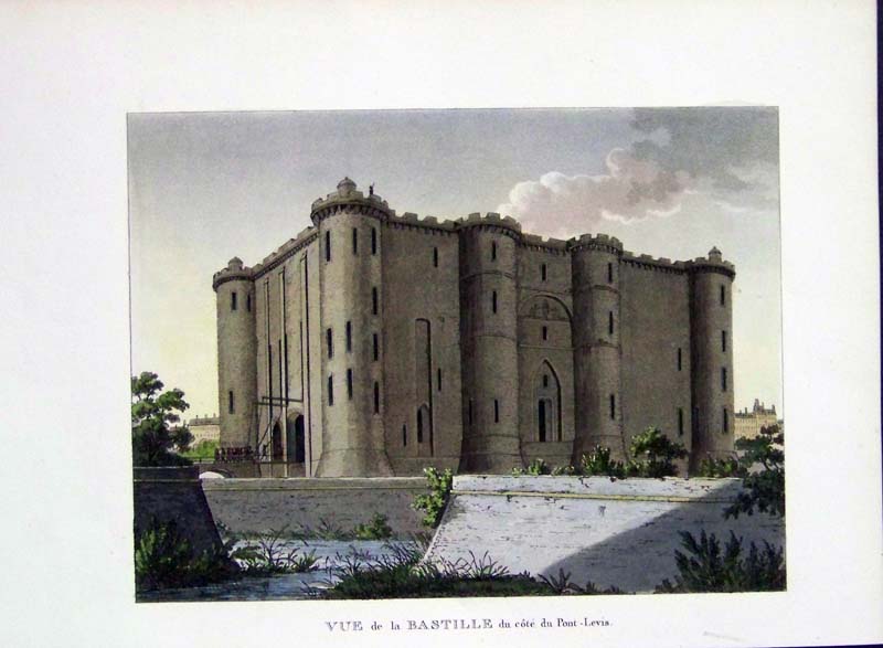
overview of Paris in 1848. Signed in the plate by Champin. This large
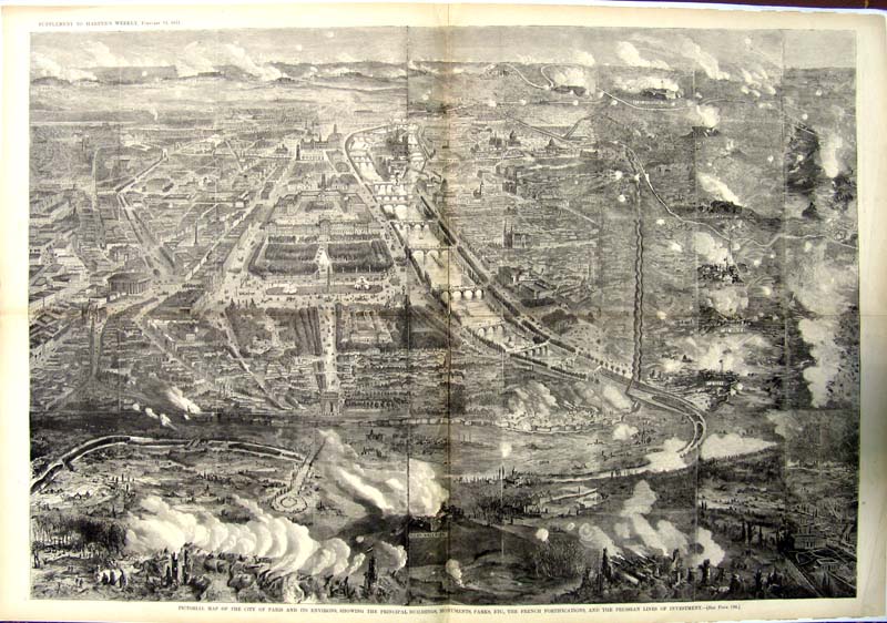
linen-mounted engraving was from a supplement to the Illustrated London
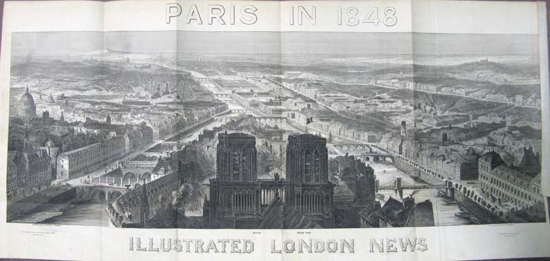
News and this photo doesn't do it justice. The folds are not as
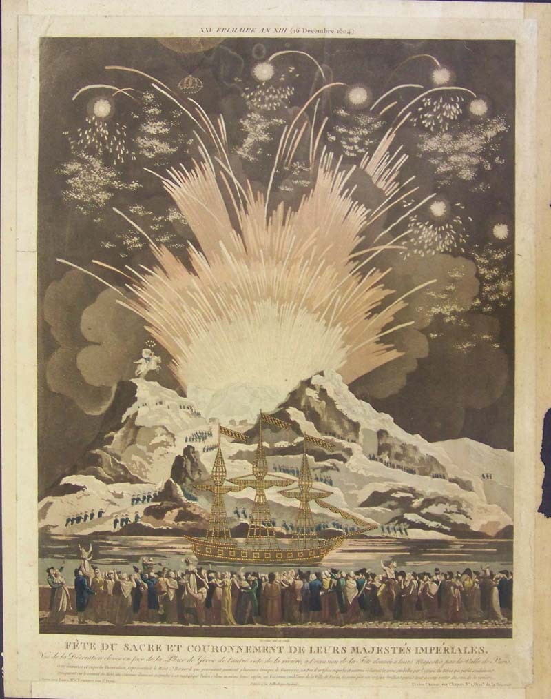
pronounced as this photo shows. Condition is very good.
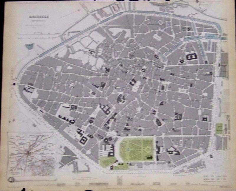
41 x 19 in. $250
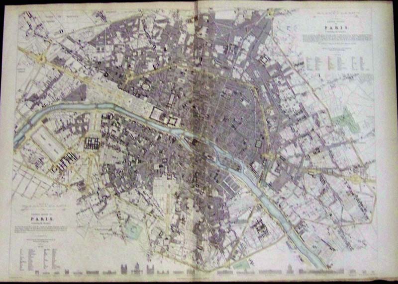
SOLD
231fra:
1804 Hand colored lithograph showing a celebration of fireworks at a
French harbor as an ornate ship sails in front of a large, cheering
crowd of citizens. Text is written in French and is titled, "Fete Du
Sacre Et Couronnement De Leurs
Majestes Imperiales."
18-1/2 x 14-1/2 in. $400
232fra:
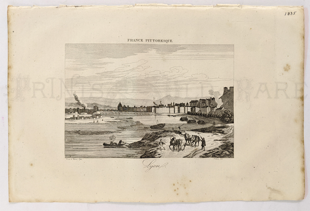
1833 Lightly hand colored steel engraved map of Brussels (Bruxelles) in
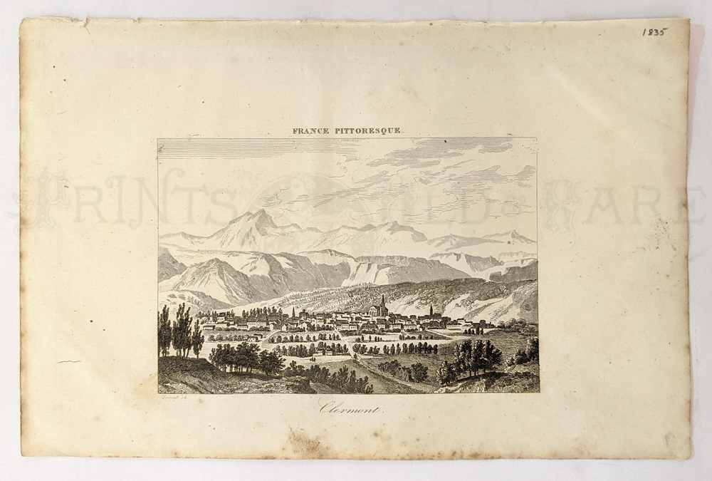
fine condition. On bottom of map it shows the comparison of heights of
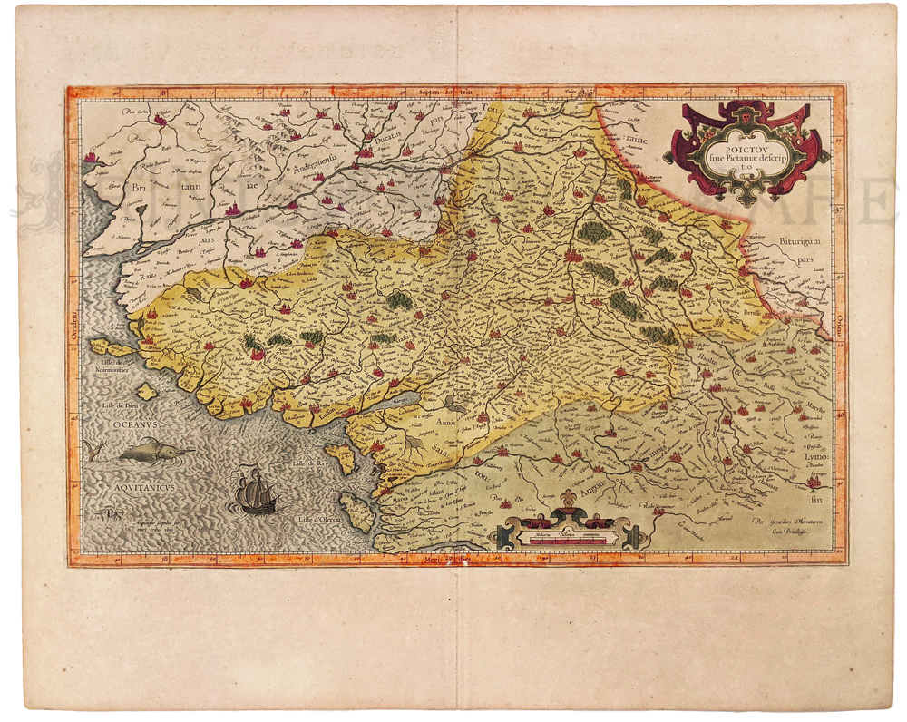
prominent buildings. Map published under the Superintendence of the
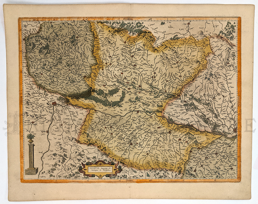
Society for the Diffusion of Useful Knowledge (S.D.U.K.) and published
by Baldwin & Cradock, London.
16 x 13-1/2 in. $200
233fra:
1841 Lightly hand colored steel engraved map of The Western Division
and the Eastern Division of Paris, Containing the Quarters. Published
under the Superintendence of the Society for the Diffusion of Useful
Knowledge (S.D.U.K.) and published by Chapman & Hall, London.
Bottom of map shows the comparison of heights of prominent buildings.
Map is in fine condition.
22-1/2 x 16 in. $350
235fra:
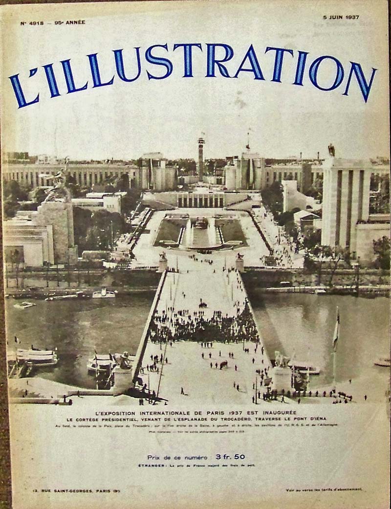
1937 L'Illustration Internationale De Paris complete 27 page issue with
text and photographs related to the exposition. Dated 5 Juin
1937.
In fine condition.
15 x 11 in. $50
236fra:
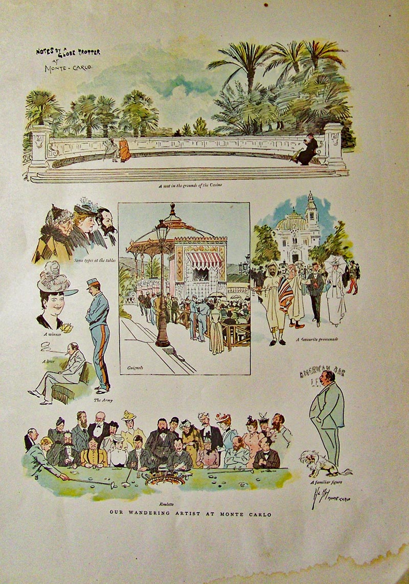
1893 Monte Carlo - The Riviera by London Graphic. Seven vignettes of
the casino, the promenade and the people. Chromolithograoh.
14 x 10 in. $60
|
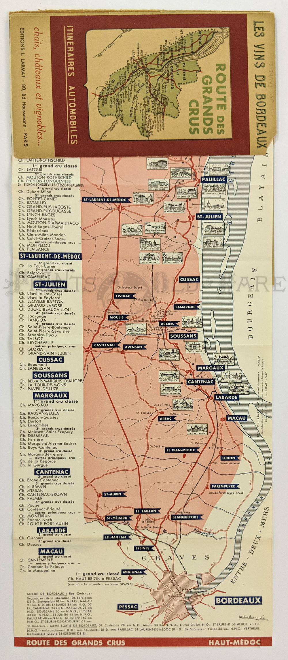
14fpm:
Wine Region: Les Vines de Bordeaux. 3 fold out maps of “Route des Grand
Crus.” Haut-Medoc, Graves – Cerons, St. Emilion, one of the most
celebrated wine routes in Europe. c. late 40s-50s. Maps are fine covers
split at spine, wine label inside cover.
19 1/8 x 8 in. $75
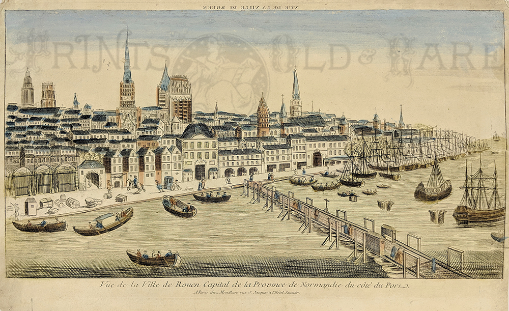
237fra:
Roven - Veud'Optique. Printed in mirror image. View of the Seine River
as it flows through the Capital City of Normandy. c.1780 Hand colored
copper engraving.
17 3/4 x 11 3/8 in. $150
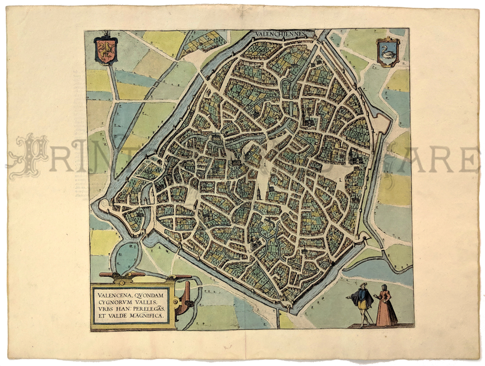
238fra:
Valencena Quondam Cygnorum Vallis. Original Braun
& Hogenberg map of Valenciennes. Beautifully hand colored
copper engraving.
13 7/8 x 15 1/8 in. $395
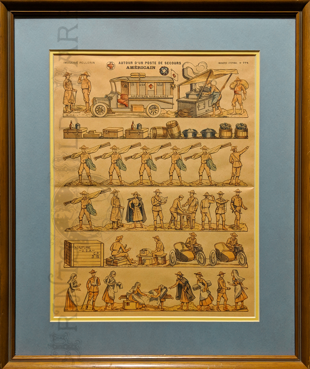
239fra:
US Ambulance Service and Red Cross c.1917. Color
lithograph by Pellerin (precursor of comics) Shows WWI motorcycles with
side cars, ambulances, cook stoves, soldiers and nuns. *Simple wood
frame – double matt.
Image size: 11 x 14 ¾ in. – Frame size: 16 ¾ x 20 ½ in. $125
241France:
Paris - Colton Map 1855. "The Environs of Paris."
Engraving. Shows Seine River, Paris proper and 1855 suburban Paris.
13 1/4 x 17 3/8 in. $75
242fra:
Lyon 1835. Original engraving of this UNESCO World
Heritage Site.
7 x 10 3/4 in. $30
243fra:
Clermont 1835 in the Auvergne Region of France. This is
one of the
oldest cities in France. This is an original bird-eye engraving.
7 x 10 3/4 in. $30
244fra:
Poictov 1613 by Mercator. Hand colored copper engraved
map of part of coast of France above Bordeaux. Map depicts ships, sea
creatures, towns, churches, river decorative cartouche.
16 ½ x 20 in. $325
245fra:
Alsatia 1614 Mercator (Hondius) - Hand colored copper
engraving shows Rhine River from Strasburg to Basle, towns, forests and
mountains.
14 x 19 in. $400
246fra:
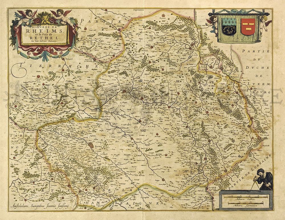
1640 Rheims, France Map by Jansson. This beautiful,
engraved map is
titled "Dioecese de Rheims, et le Pais de Rethel." Original hand
coloring and considerable detail make this a very attractive map. It is
in very good condition, with no stains, tears or other blemishes on the
image. A small split along the center crease is in the margin only; the
image itself is not affected.
Paper size is 19"x23",
and image size is 15"x19".
$350
247fra:
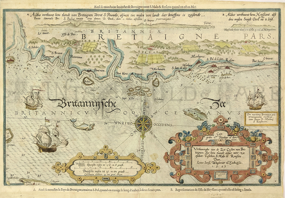
1583 Brittany, France. First Printed Chart of
Brittany's Northern
Coastline. This rare, beautiful chart is titled "Verthoninghe van de
Zee Custen Van Bretaignen." It was published by Dutch cartographer L.J.
Waghenaer in his 1583 "Spieghel Der Zeevaerdt." In addition to being
historically significant, it is also extremely decorative. The chart
title and scale of distances are surrounded by intricate designs. This
chart is in excellent condition,
and has been
beautifully hand colored.
15x21 in. $2,500
248fra:
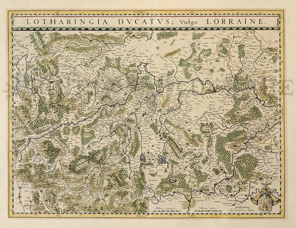
1640 Blaeu Map of Lorraine, in Eastern France. This
beautifully
hand colored, engraved map was published circa 1640 by Dutch mapmaker
William Blaeu. It is titled "Lotharingia Ducatus; Vulgo Lorraine." The
map image centers on the city of Nancy, with parts of Alsace and
Burgundy on the far left side.
Size is 15x19.5 in.
$300
249fra:
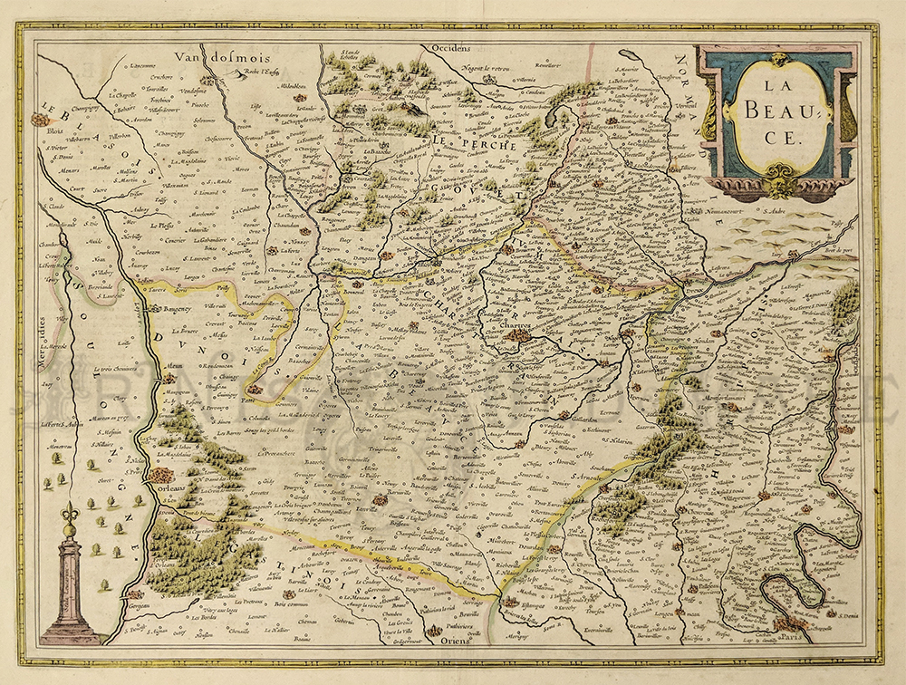
1633 France. Hand colored copper engraved map titled,
"La Beau Ce,"
published by H. Hondius in Amsterdam in 1633. Map has a beautiful
cartouche of the Beauce region of France which is flanked by Paris on
the Siene to the north and Orleans on the Loire to the south. Map is in
very good condition with mended middle seam.
22 x 18 in. $550
250fra:
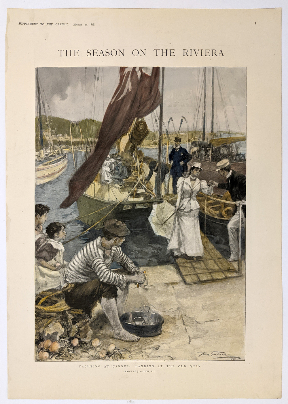
Yachting at Cannes: Landing at the Old Quay. French
Riviera. 1889 Supplement to the Graphic. Hand colored, half-tone.
11 3/8 x 15 ¾ in. $60
251fra:
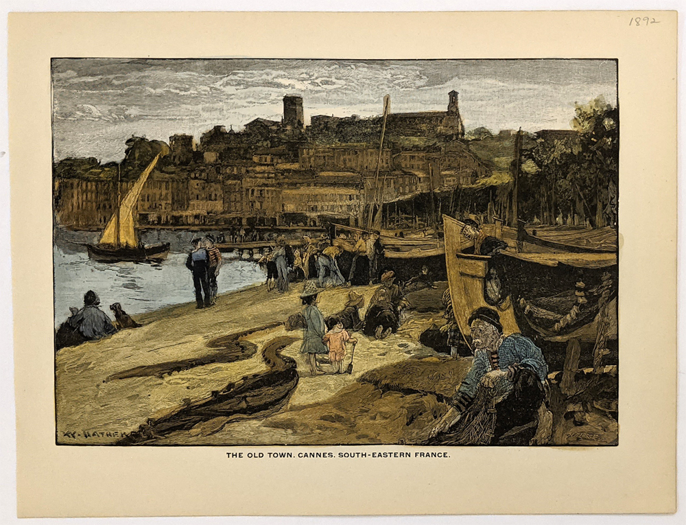
The Old Town, Cannes. South-Eastern France. 1892.
8 3/8 x 10 ¾ in. $50
252fra:
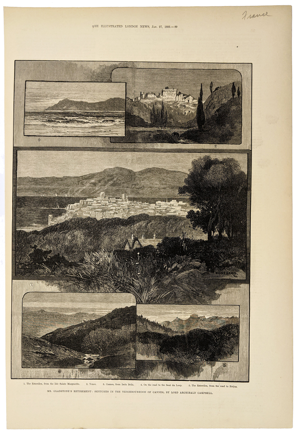
Cannes 1883 - French Riviera Scenes. Mr. Gladstone’s
Retirement:
Sketches in the Neighborhood of Cannes. Illustrated London News. Wood
engraving.
11 x 15 ¾ in. $40
253fra:
Monte Carlo 1923 Riviera "Where The Sun Always Shines"
- 5 photo views in a enticing ad listing all the things to enjoy.
10 3/8 x 15 1/4 in. $30

254fra:
Monte Carlo 1935 Song Sheet "One Night in Monte Carlo"
- Published
in a NY, music and lyrics included features Kathleen Wells on the cover.
9 1/8 x 12 in. $20
255France:
Biarritz - La Villa Eugenie. Bay of Biscay. c. 1870.
Hand colored lithograph after Henry Heulz. Stylish resort of royalty on
France's SW coast - today is Europe's surfing capital. **Water stain
bottom border. Minor rips/tears along bottom and top right borders.
18 5/8 x 24 in. $150
256France:
Berry Ducatus 1606 Mercator / Hondius. France near
Bourges. Hand colored, copper engraving.
18 3/8 x 22 1/4 in. $225
033ndis: Sketches in the Riviera,
France. 6 views showing the area disturbed by the recent earthquakes.
1887 Harper's Weekly. Wood engraving.
16 x 11 in. $40
|
|