002hi:
1868
Hawaii Map. Antique Harper's map of Commercial World, with Hawaii at
center of Pacific routes. Fine hand colored Honolulu view above. Map
surrounded with five other key location views, including Hong Kong,
Panama, etc.
22x16 in. $50
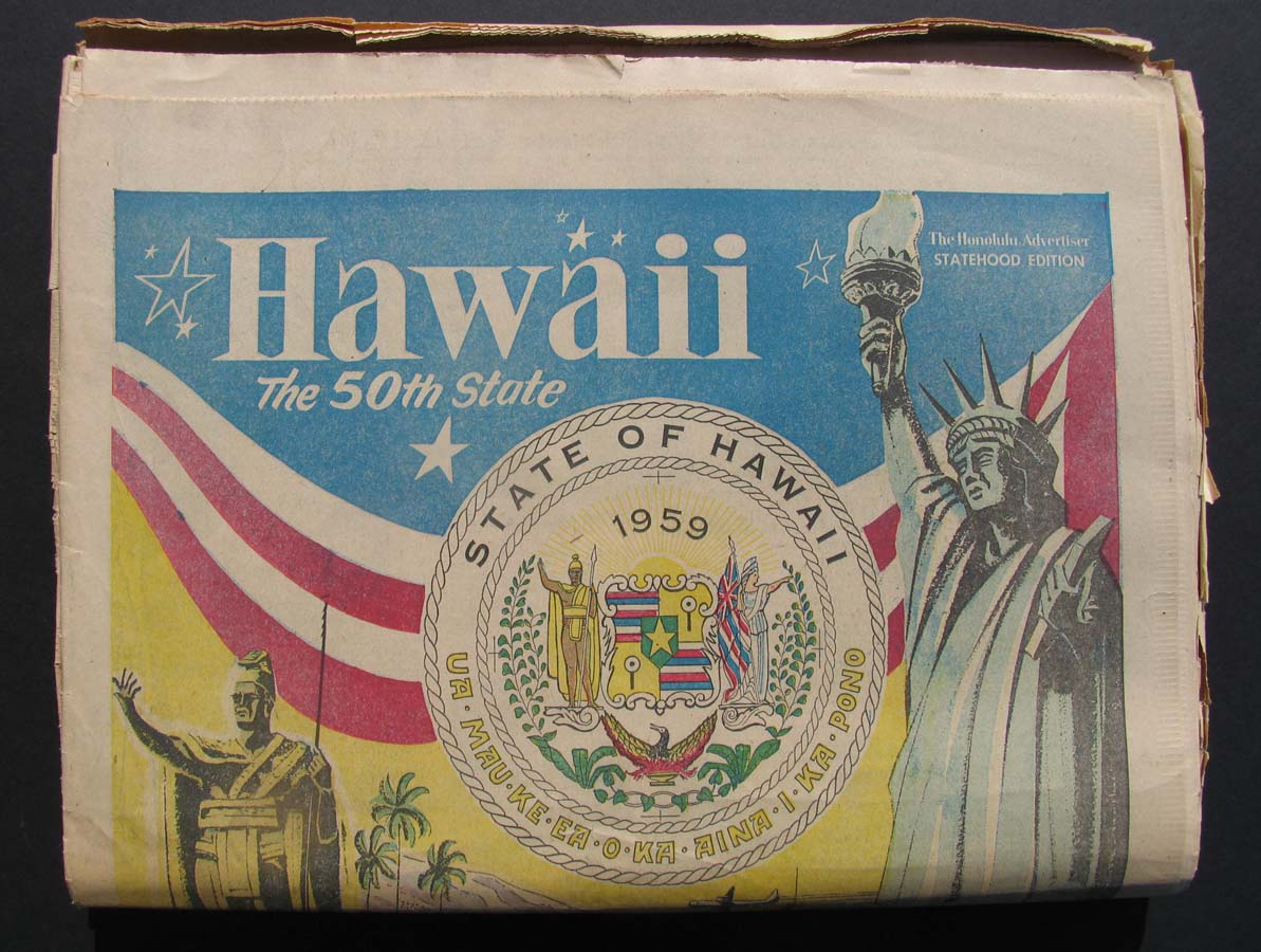
003hi:
Honolulu Advertiser - Statehood
Edition. Complete with 18 sections, published on day of Statehood.
Shown inside are photos, ads, stories, and other important points of
interest. It's in very good condition.
21 x 14-1/2 in. $175
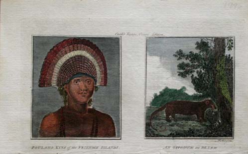
009hi:
1777
Cook. Hand colored copper engraving of Poulaho, King of the Friendly
Islands, at the time of
Captain Cook's visit.
5x9 in. $60
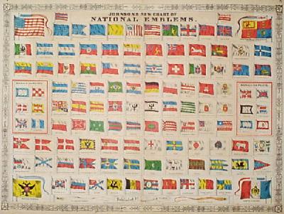
015hi:
1867
Hawaii Flag. Alone with all other independent nations shown in this
large color lithograph by Johnson's.
A great conversation piece.
26x18-1/2 in. $120
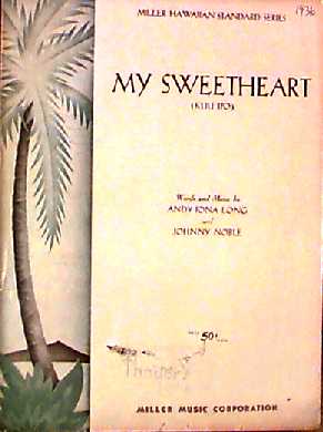
016hi:
1936
SHEET MUSIC FROM HAWAII. "My Sweetheart (Kuu Ipo)," from the Miller
Hawaiian Standard Series, 1936. Words and music by Andy Iona Long and
Johnny Noble. Originally sold by Thayer's, Honolulu.
Damaged area 2"
from
bottom of each page.
9" x 12" $30
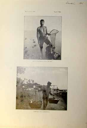
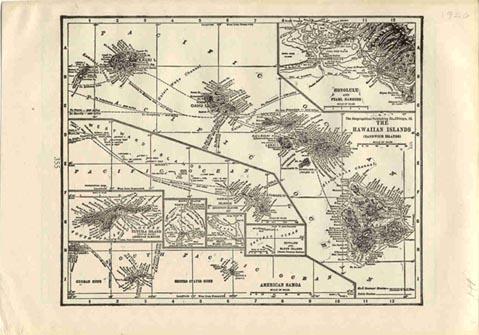
020hi:
1905
Hawaiian Fishermen print. Two early black & white photos:
Native
fisherman with dip net, and carrying fish in baskets. 7-1/2x10-1/2 in.
$30
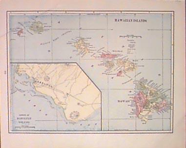
027hi:
1901 Hawaii Map. Original color antique map. Inset of southern Oahu,
from Pongo Village to Diamond Head. 14x11-1/2 in. $40
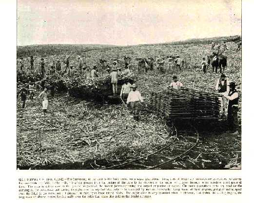
028hi:
1886
PRINT - GATHERING OF THE CANE. Sharp black & white half-tone
print
published in 1896. Shows field workers loading cut cane onto carts,
which will be whisked to the
mills by rail. Caption
is very
descriptive.
11-1/2" x 9-1/2" $30
034hi:
1920
Pacific Islands Map. Small black & white old map, showing
several
islands, including Hawaii, Samoa, Wake, Midway. Inset of Honolulu.
8-1/2x6 in. $30
035hi:
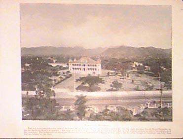
1900
Royal Palace view. Antique color aerial-photo engraving of the former
Royal Palace on Oahu. Shows part of surrounding Honolulu. Horse and
carriage driving on road
in the foreground.
13x9-1/2 in. $40
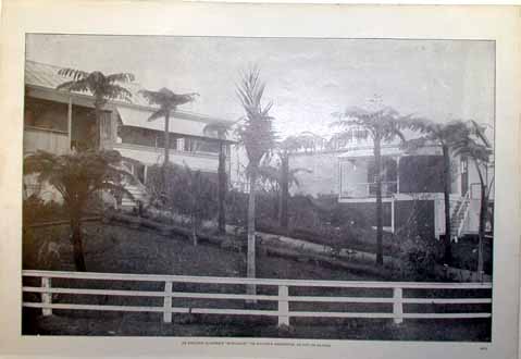
037hi:
1900
English Planter's Bungalow. Black & white old photo engraving
of a planter's country residence
on the Big Island.
15-1/2x10-1/2 in. $30
038hi:
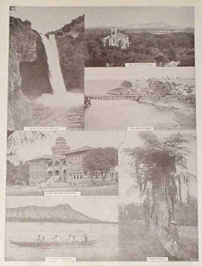
1890
Hawaiian views. Six black & white old half-tones, showing
bridge at
Hilo, native fishermen at Diamond Head, Wailua Falls, Oahu College,
others. Small hole and
stain on Hilo image.
11-1/2x14-1/2 in. $30
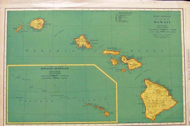
039hi:
Color Rand McNally Hawaii map showing
all the Hawaiian islands with an inset of the Hawaiian Archipelago.
Featured in the Commercial Atlas.
A guide to the Railroads in Hawaii
is shown on top of map.
20-1/2 x 14 in. $80
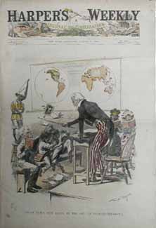
042hi:
1898
Hawaii as New U.S. Possession Cartoon. Uncle Sam as headmaster in class
in the art of self-government, in which Hawaii is a good student. Hand
colored
original front page from Harper's.
11x16 in. $60
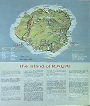
044hi:
1968
Kauai Travel Brochure. Color brochure includes large tourism map with
many points of interest, as well as Kauai facts and several color
photos of scenes around the Island. Printed both sides.
15x18 in. $30
046hi:
1860
Mitchell Map of Oceanica. Beautiful original hand colored antique map
of the Pacific, has inset of the Sandwich Islands (Hawaii), and
Australasia. Attractive
border, very frameable.
15-1/2x12 in. $90
047hi:
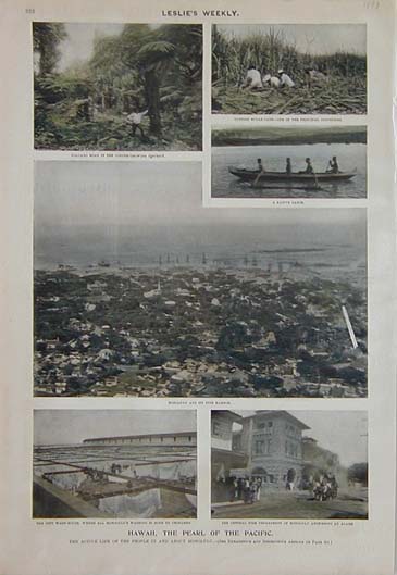
1898
Hawaii the Pearl of the Pacific. The actibe lif ot the people in and
about Honolulu. Six hand colored half tones show: volcano road in the
coffee growing district, cutting sugar cake-one of the principal
industries, a native canoe, Honolulu and it's fine harbor, the city
Wash-House, where all Honolulus washing is done by chinamen, the
Central Fire Department of Honolulu answering an alarm. This unique
print is from the 1898 edition
of Leslie's Weekly.
11x16 in. $60
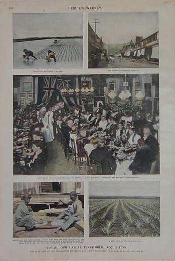
048hi:
1899
Hawaii, Our Latest Territorial Acquisition. The Busy Life of the
Interesting People In and About Honolulu. This hand colored set of
seven half tones shows: planting a rice field in Hawaii, the Chinese
Quarters in Honolulu, native feast given by Princess Kaiulani at her
palace in Honolulu in honor of the Hawaiian Commissioners, making Poi,
a pineapple ranch near Honolulu. This unique print is from the
October
1899 edition
of Leslie's Weekly.
11x16 in. $60
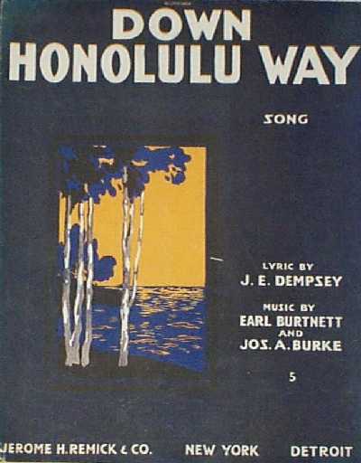
105hi:
1916
Sheet Music: "Down Honolulu Way." Complete music to the song, with an
attractive color lithographed cover. Would look very nice in a frame!
All pages are included, in very good condition.
11x14 in. $30
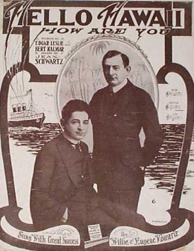
106hi:
1915
Sheet Music: "Hello Hawaii, How Are You?" Cover features a Hawaiian
scene, with portraits of two singers who popularized the song.
11x14
in. $30
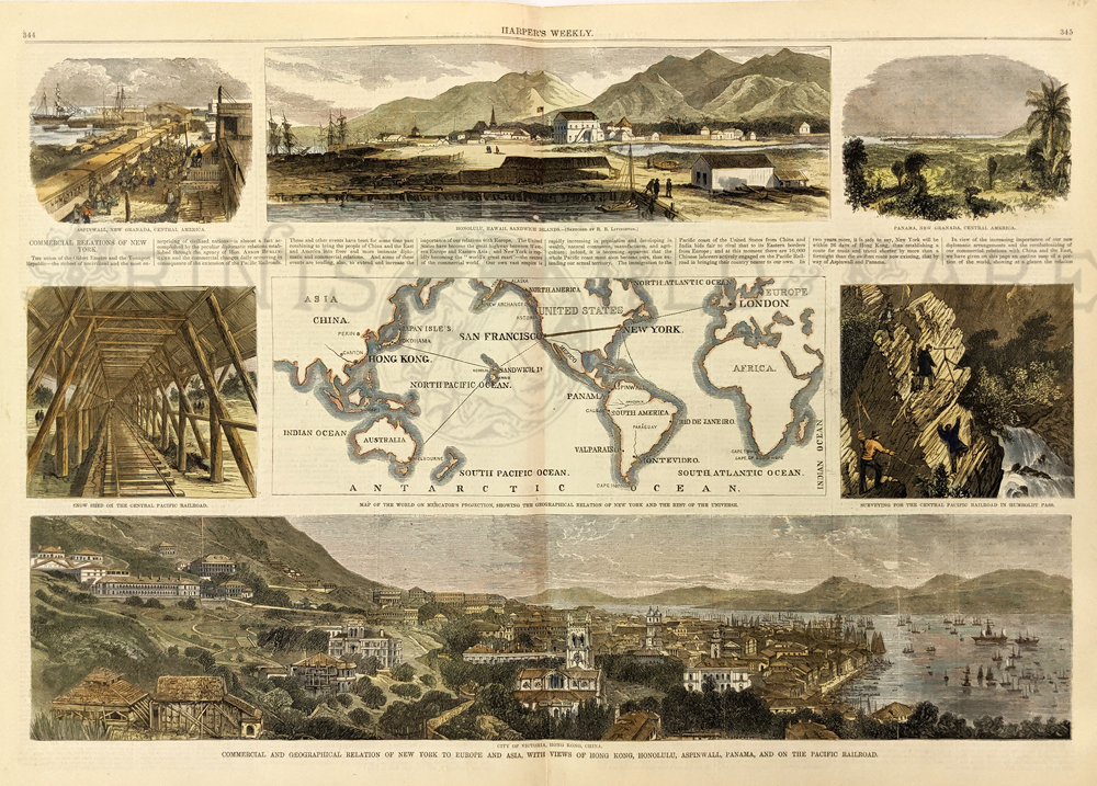
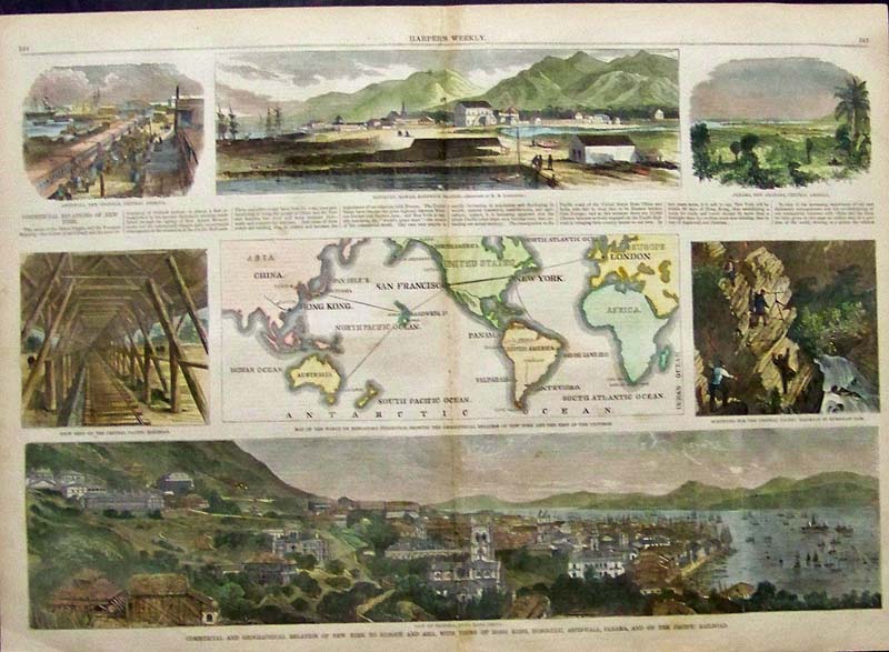
307nyc:
New York - Commercial and Geographical of relations with the rest of
the world in 1868. Areas including Birdseye views of Honolulu, Hong
Kong, Panama and UPRR. Hand colored, wood engraving.
15 ½ x 22 in. $80
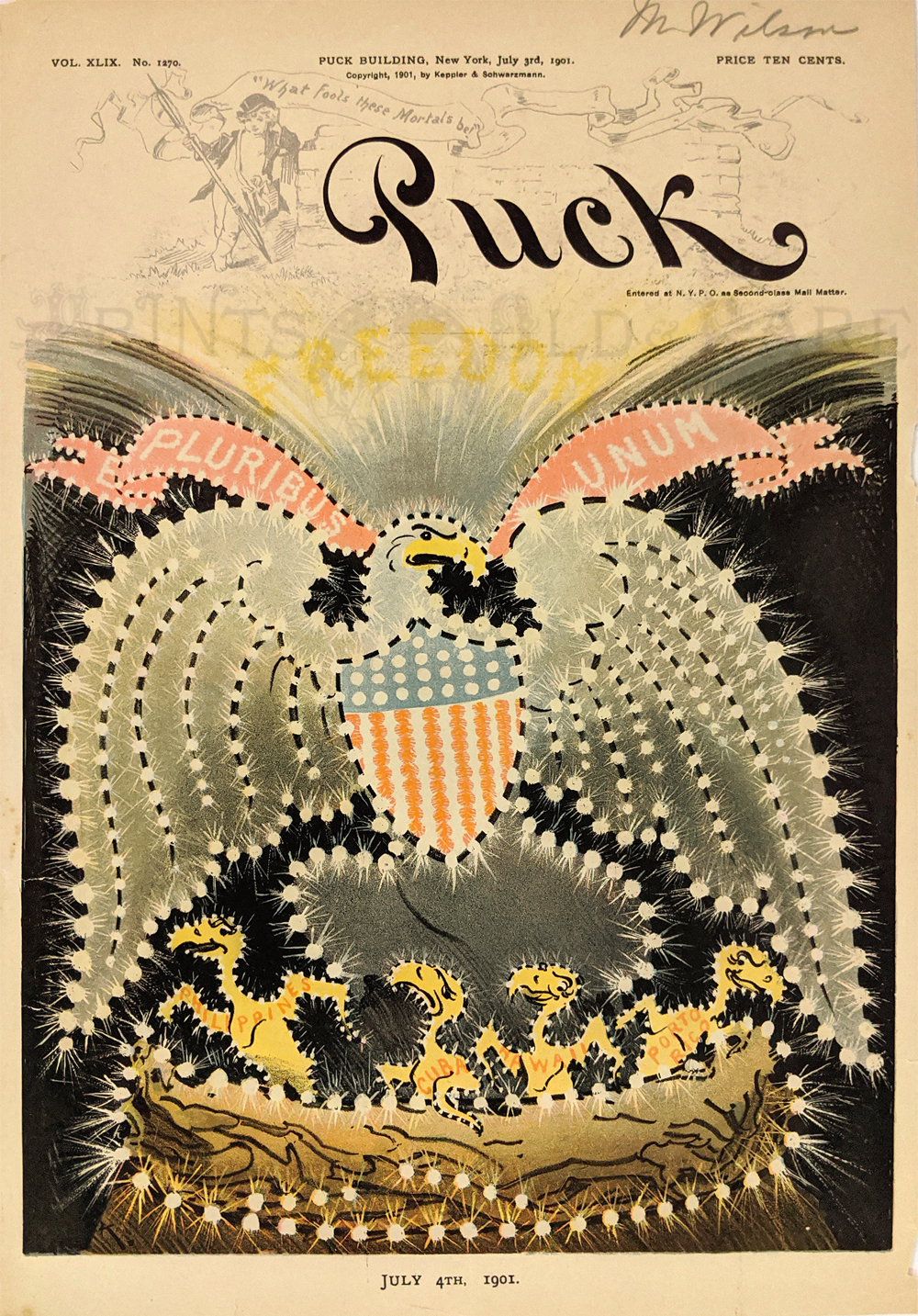
009pat: Imperial US Eagle
Spreading Wings over
Philippines, Cuba, Hawaii and Porto Rico as chicks in the nest.
Chromolithograph cartoon during Spanish American War era. 1901 Puck
Cover.
9 ½ x 13 3/8 in. $60
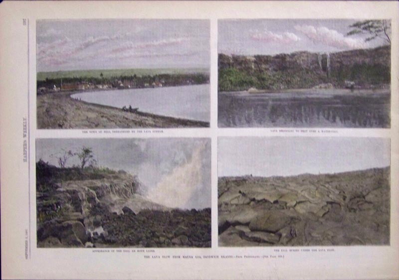
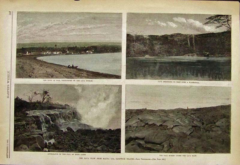
024ndis: 1881
Hand colored wood engravings featured in Harper's Weekly showing four
views of "The Lava Flow from Mauna Loa, Sandwich Islands."
15-1/2 x 11 in. $50
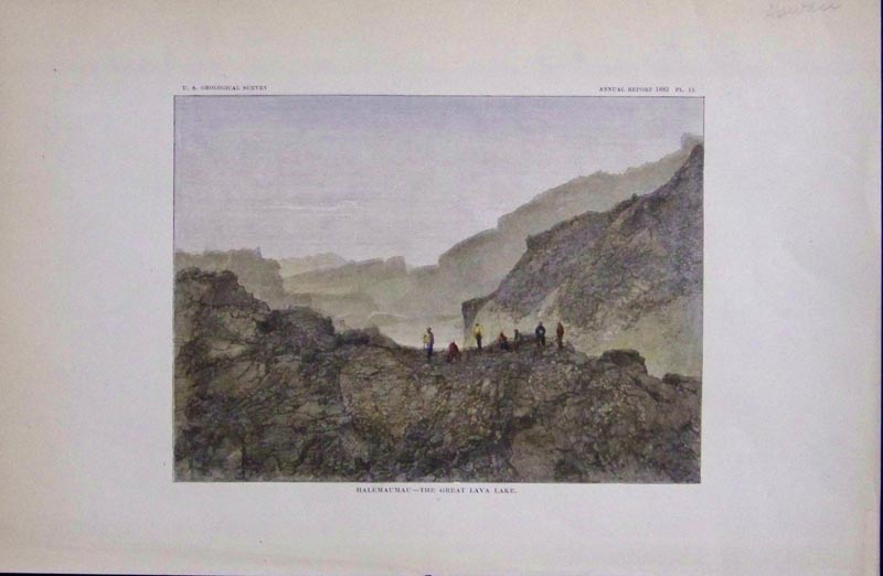
028ndis: 1883
Hand colored wood engraving from the U.S. Geological Survey's Annual
Report, Pl. IX showing, "Halemaumau -- The Great Lava Lake." in Hawaii.
11-1/2 x 7-1/2 in. $30
|
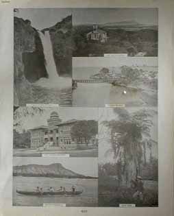
107hi:
1901
Photographic views in Hawaii. Six nice black and white images on one
page: 1) Wailua Falls; 2) Old Native Church; 3) Village of Hilo; 4)
Oahu College Building; 5) Native Fishermen; and 6) Fern Tree. 12x15 in.
$30
Click here to see more views from
Captain Cook's Voyages.
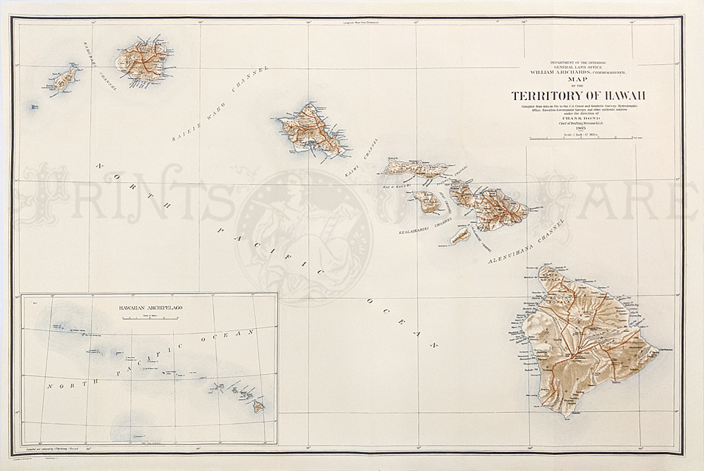
201hi:
1905 Territory of Hawaii color map with inset of the
Hawaiian Archipelago.
34 x 23-1/2 in. $200
Check
for Availability
205hi:
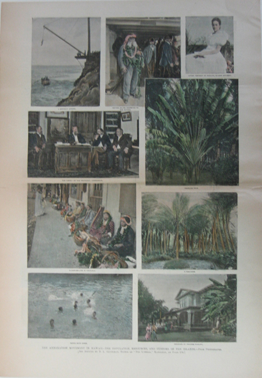
1892
Pictures of the annexation movement in Hawaii, including the
population, resources and customs of the islands. Hand colored engraved
images titled, "The Annexation Movement in Hawaii-The Population,
Resources, and Customs of the Islands, A Difficult Landing, Captain
Wiltbe Decorated by the Natives, Latest Portrait of Kaiulani, Ex-Heir
Apparent, The Cabinet of the Provisional Government, Traveling Palm,
Flower Sellers in Honolulu, A Fish Pond, Native Boys Diving and
Residence of the Princess Kaiulani," from Frank Leslie's Weekly.
11 x
16in. $60
207hi:
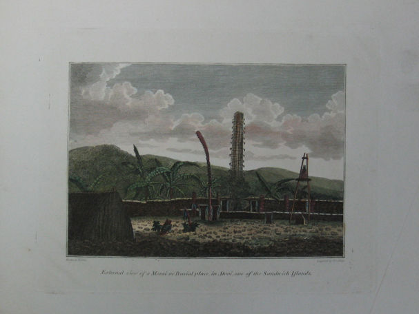
c1810
Picture of External View of Morai or Burial place, in Atooi, one of the
Sandwich Islands. Hand colored engraved image titled, "External view of
a Morai or Burial Place, in Atooi, one of the Sandwich Islands," drawn
by Webber. Shows scene of burial place in Atooi.
10 1/2 x 8in. $80
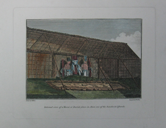
208hi:
c1810
Picture of Internal View of Morai or Burial place, in Atooi, one of the
Sandwich Islands. Hand colored engraved image titled, "External view of
a Morai or Burial Place, in Atooi, one of the Sandwich Islands," drawn
by Webber. Shows scene of burial place in Atooi.
10 1/2 x 8in. $80
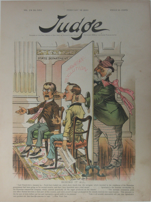
210hi:
1893
Picture of Political Cartoon with Claus Spreckels insinuating that he
wants to gain control of the Hawaiian government. Hand colored engraved
image titled, "Behind it all," from Judge Publishing. Shows Claus
Spreckels controlling two dummies representing the Hawaiian Commission
and
Hawaiian Commissioner.
11 x 16in. $80
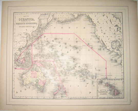
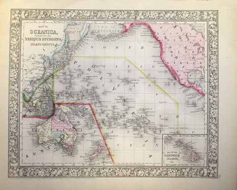
212hi:
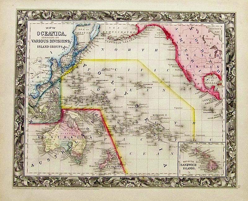
1884
Map of Oceanica, Exhibiting Its Various Divisions, Island Groups
&c. - With inset of Map of the Sandwich Islands in bottom right
corner. Copyright by S. Augustus Mitchell, 1884. Map displays section
of the North Pacific Ocean. Map in excellent condition with thin-lined
black border surrounding it. 12x15in. $80
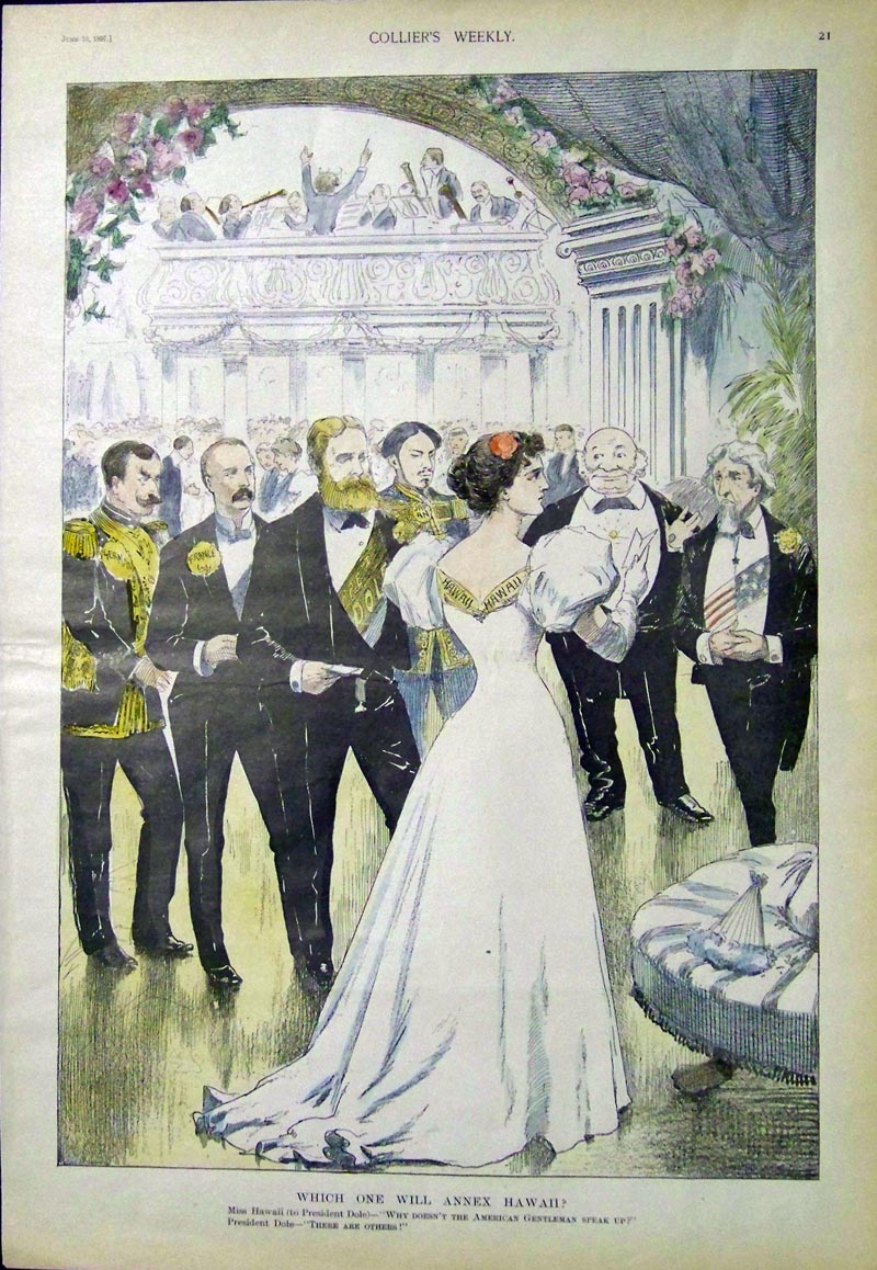
215hi:
1897
Collier's Weekly hand colored wood engraving captioned, "Which One Will
Annex Hawaii?" Scene shows Miss Hawaii standing next to President Dole
and
representatives from other
countries asking, "Why
Doesn't the
American
Gentleman Speak Up?"
15 x 10-1/2 in. $250
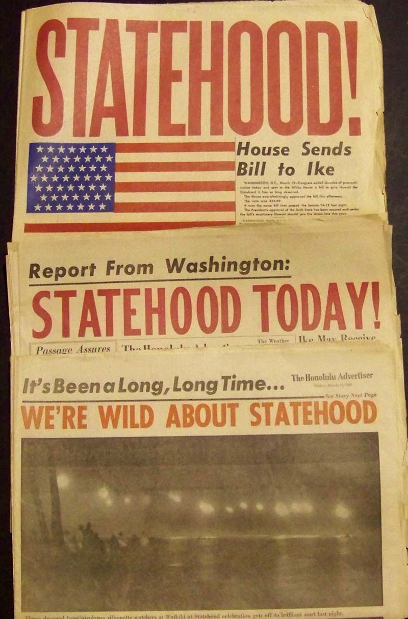
216hi:
1959
Set of three original Hawaii Statehood complete newspapers, all in good
condition. Set includes the Honolulu Star Bulletin dated March 12,
1959; the Honolulu Advertiser dated March 12, 1959; and the Honolulu
Advertiser dated March 13, 1959. All are very frameable.
Each
newspaper,
unopened, measures:
23 x 15-1/2 in. $75
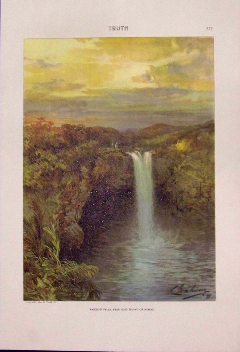
217hi:
1899
Chromolithograph by Charles Graham titled, "Rainbow Falls, Near Hilo,
Island of Hawaii." Copyright 1899 by Truth Company. Top of
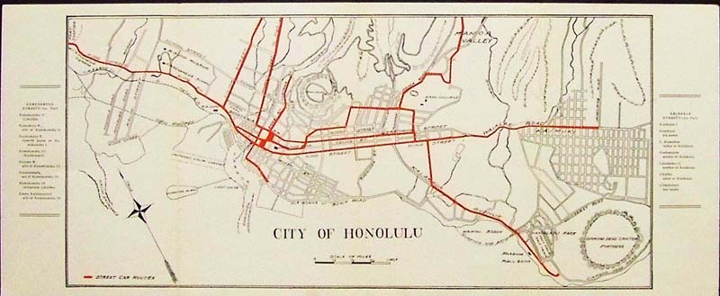
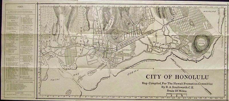
page reads
Truth.
13-1/2 x 9-1/2 in. $45
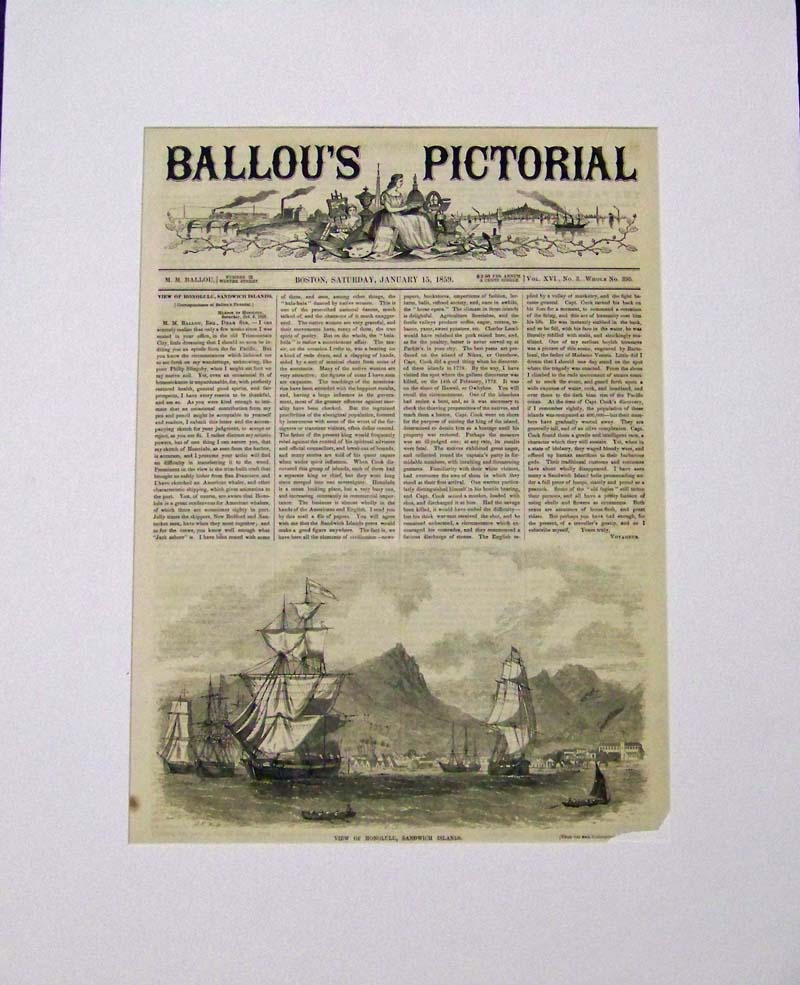
218hi:
1859
Original wood engraving featured in Ballou's Pictorial titled, "View of
Honolulu, Sandwich Islands." Clipper ships are shown in foreground and
mountains in background with article concerning kings, agriculture,
Captain Cook and his discovery. Image is
in fine condition.
15 x 11 in. $60
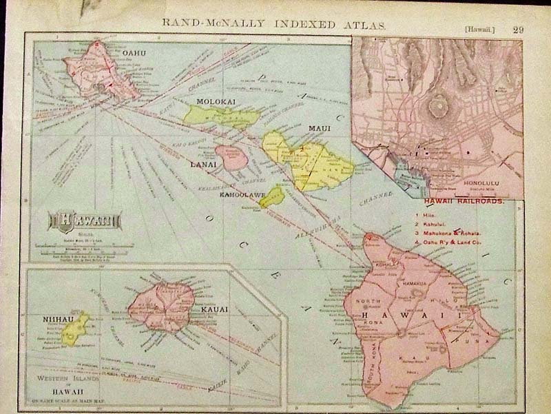
220Hawaii:
1909 Rand-McNally Indexed Atlas of Hawaii with inset of the Western
Islands of Hawaii which include Kauai and Niihau.
14 x 10 in. $50
222Hawaii:
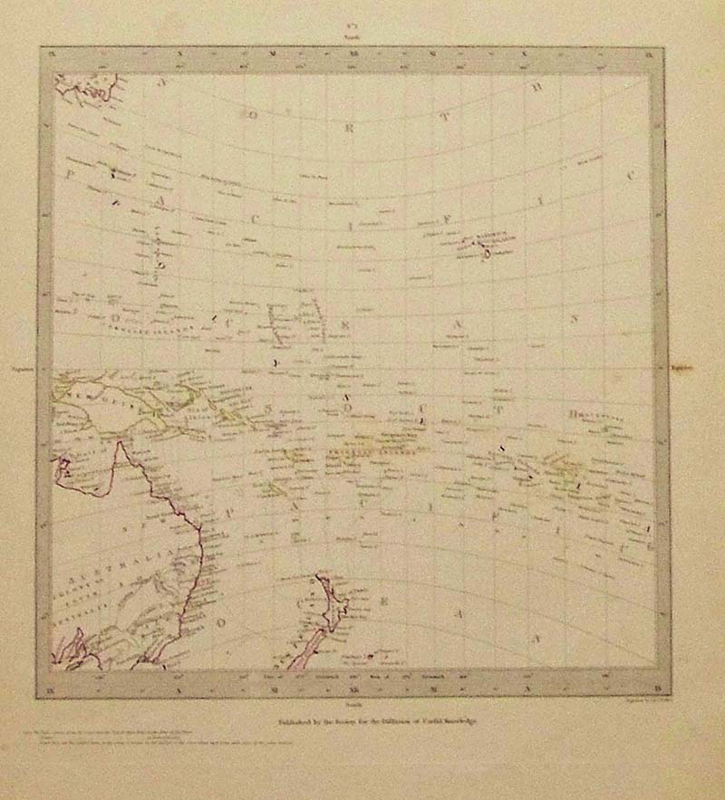
1844 Engraved "Polynesia," map, Volume II, published by the Society for
the Diffusion of Useful Knowledge (S.D.U.K.).
16 x 13 in. $150
223Hawaii:
1860 Hand colored Augustus
Mitchell Map of Oceanica, Exhibiting Its Various Divisions &
Island
Groups. Bottom right corner shows inset Map of the Sandwich Islands.
15-1/2 x 12-1/2 in. $90
224Hawaii:
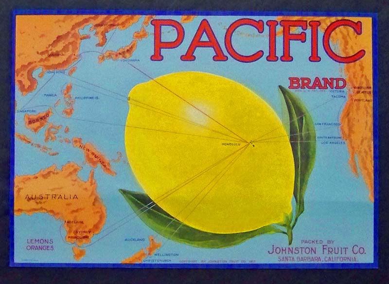
1917 Schmidt color lithographed
Pacific Brand Johnston Fruit Coompany of Santa Barbara, California
fruit label showing the Hawaiian Islands in the center of a large lemon
with
Honolulu pointed out.
12-1/2 x 8-1/2 in. $30
225Hawaii:
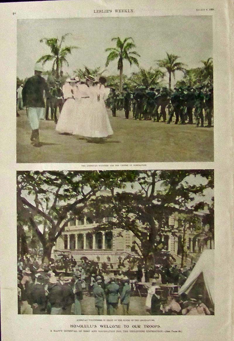
1898 Hand colored half-tone
images featured in Leslie's Weekly shows Honolulu's Welcome to Our
Troops in a happy interval of rest and recreation for the
Philippine
Expedition.
15-1/2 x 11 in. $60
226Hawaii:
1881 Wood engravings from Harper's Weekly showing affects of the Lava
Flow from Mauna Loa, in the Sandwich Islands.
16 x 10-1/2 in. $50
227Hawaii:
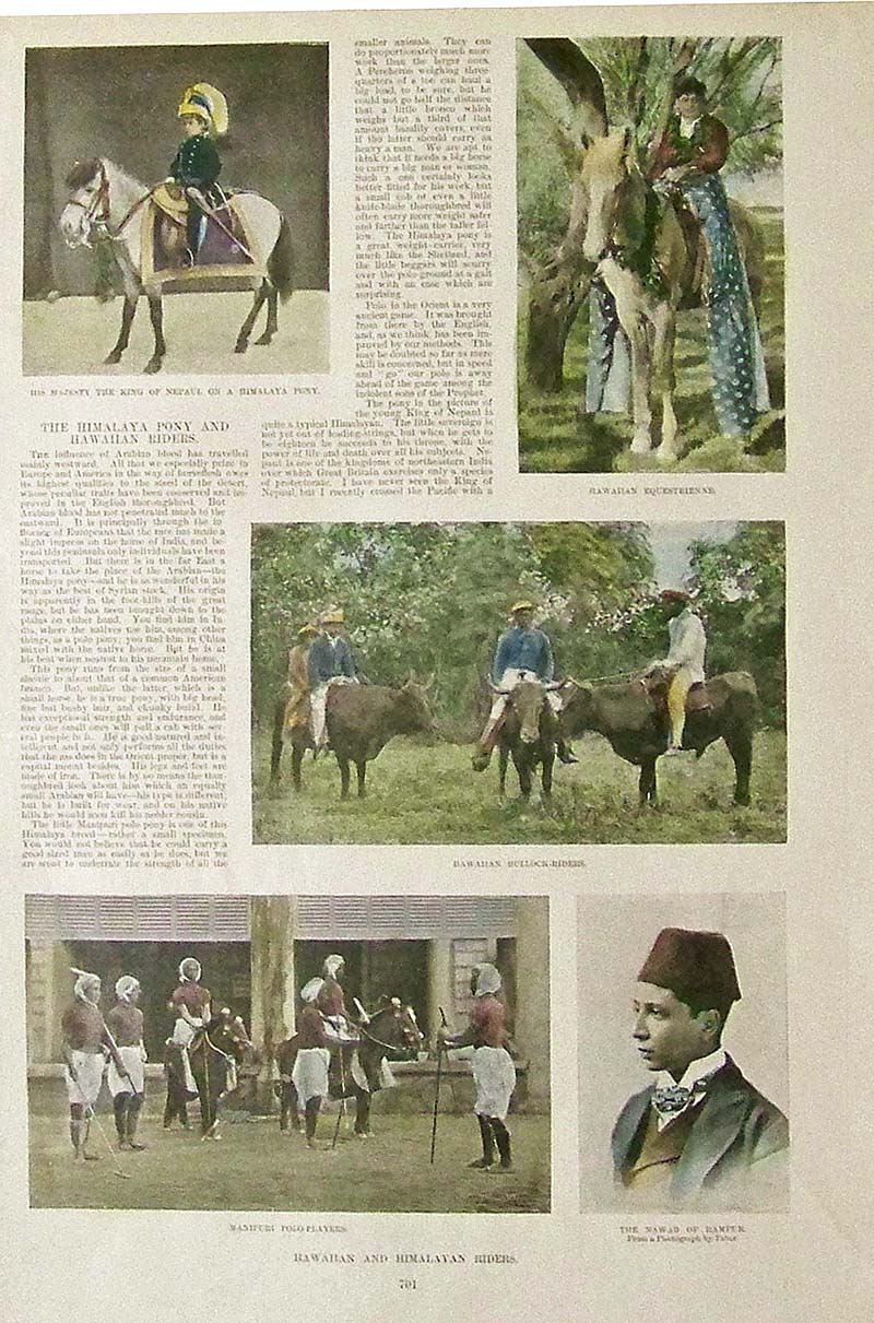
1893 Hand colored half-tone images from Harper's Weekly showing
Hawaiian and Himalayan Riders.
15-1/2 x 10-1/2 in. $40
228Hawaii:
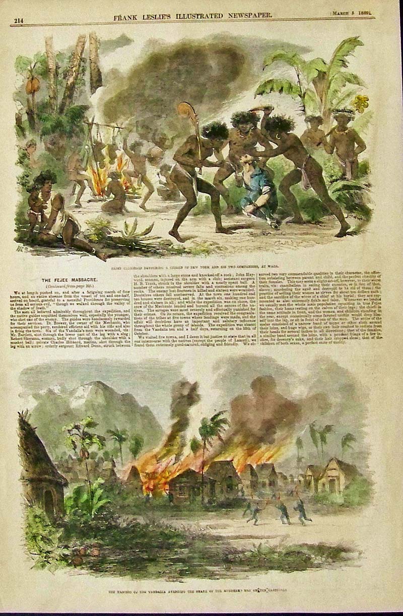
1859 Hand colored wood engravings
from Frank Leslie's Illustrated Newspaper showing cannibals readying
their human prey in top image and bottom image shows the Marines of the
Vandalia avenging the death of the murdered
men of the cannibals.
15-1/2 x 10-1/2 in. $70
229Hawaii:
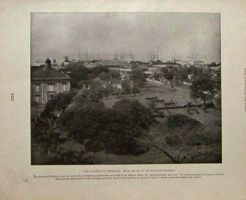
1899 Half-tone showing the Harbor
of Honolulu, (From the top of the Executive Building). Featured in The
Hawaiian Islands publication.
14 x 11 in. $40
230Hawaii:
1898 Leslie's Weekly hand colored
half-tone titled, "The First Christmas in Hawaii." Signed by C.F. Budd.
Image shows a Hawaiian lady standing under the mistletoe in hopes that
the soldier standing guard might give her a kiss.
16 x 11 in. $50
027ndis: 1874 Wood engraving from
Harper's Weekly showing six views of the Grand Crater on "The Island of
Vulcano.
16 x 11 in. $40
|
254Hawaii:
Dole Map of the Hawaiian Islands. Original 1950 lithograph map by
Joseph Feher for the Dole Pineapple Co. **Minor discoloration top and bottom borders. Spot top right quadrent as well.
23 3/8 x
40 5/8 in. $800
257Hawaii:
Sandwich Island Flag. 1854. “Flags of all Nations.” Chart f 70 National
flags including the Sandwich Islands. Wood engraving.
15 x 22 ¼
in. $65
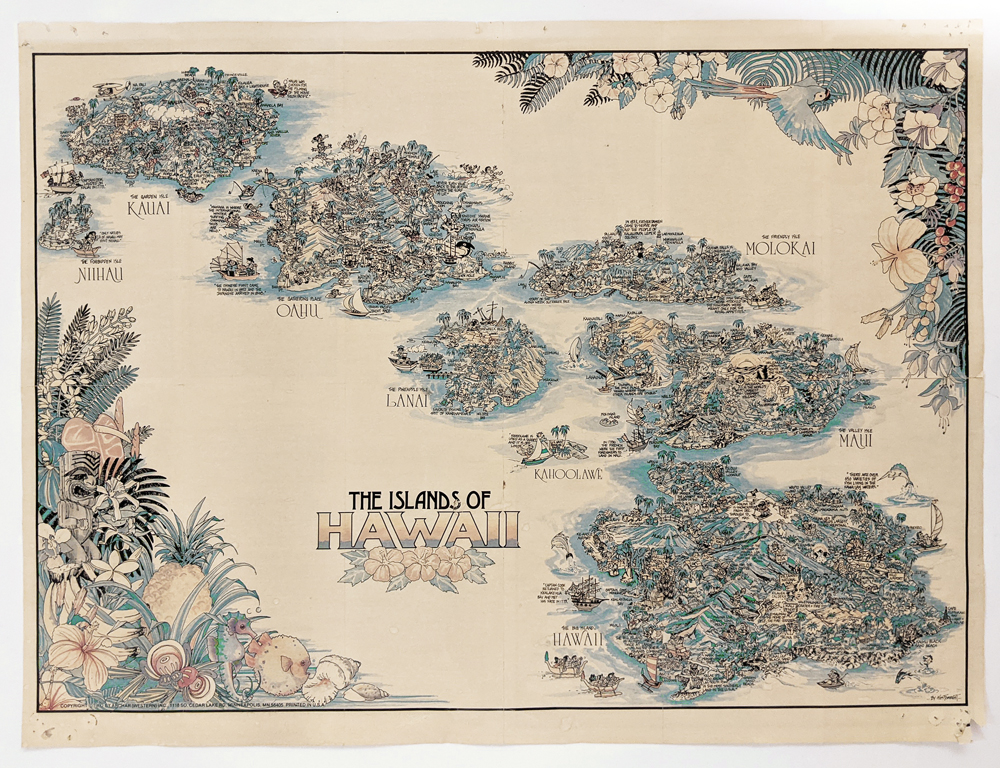
016pictorialmaps:
Hawaii Map 1970s by Kim Forrest. Charming pictorial of the Hawaiian
Island depicting locations and history. *Pinholes on corners where map
was pinned up. Originally folded and now mended along center right
fold.
23 x 17 1/4 in. $345
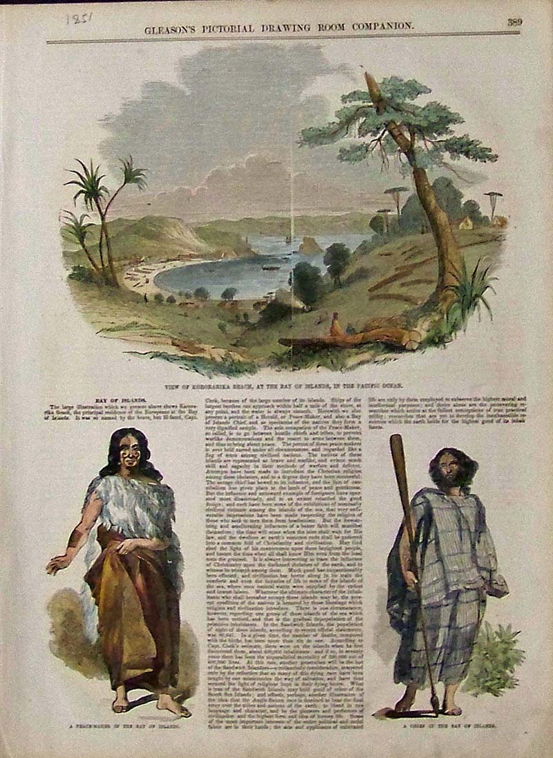
231Hawaii:
1851 Hand colored wood engravings featured in Gleason's Pictorial
Drawing Room Companion. Top image shows a View of Kororarika Beach, at
the Bay of Islands, in the Pacific Ocean. Bottom left shows a
Peace-Maker in the Bay of Islands and bottom right shows A Chief in the
Bay of Islands. The Bay of Islands text surrounds the images.
15 x 11 in. $60
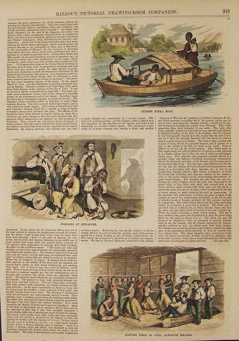
232Hawaii:
Hand colored wood engravings featured in Ballou's Pictorial
Drawing-Room Companion showing Dancing Girls of Oahu, Sandwich Islands
in bottom image.
14-1/2 x 10-1/2 in. $50
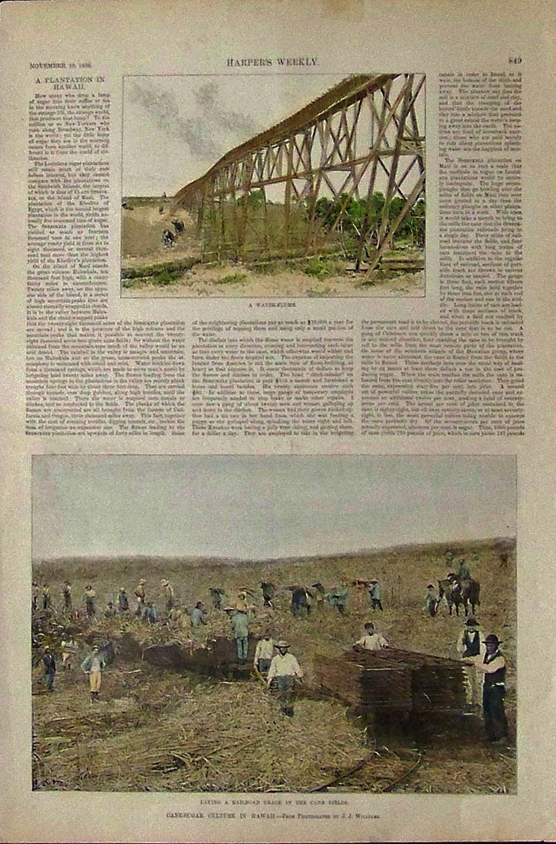
233Hawaii:
1888 Harper's Weekly hand colored half-tones showing men laying a
railroad track in the sugar-cane fields in bottom image and a
Water-Flume in top image.
16 x 11 in. $50
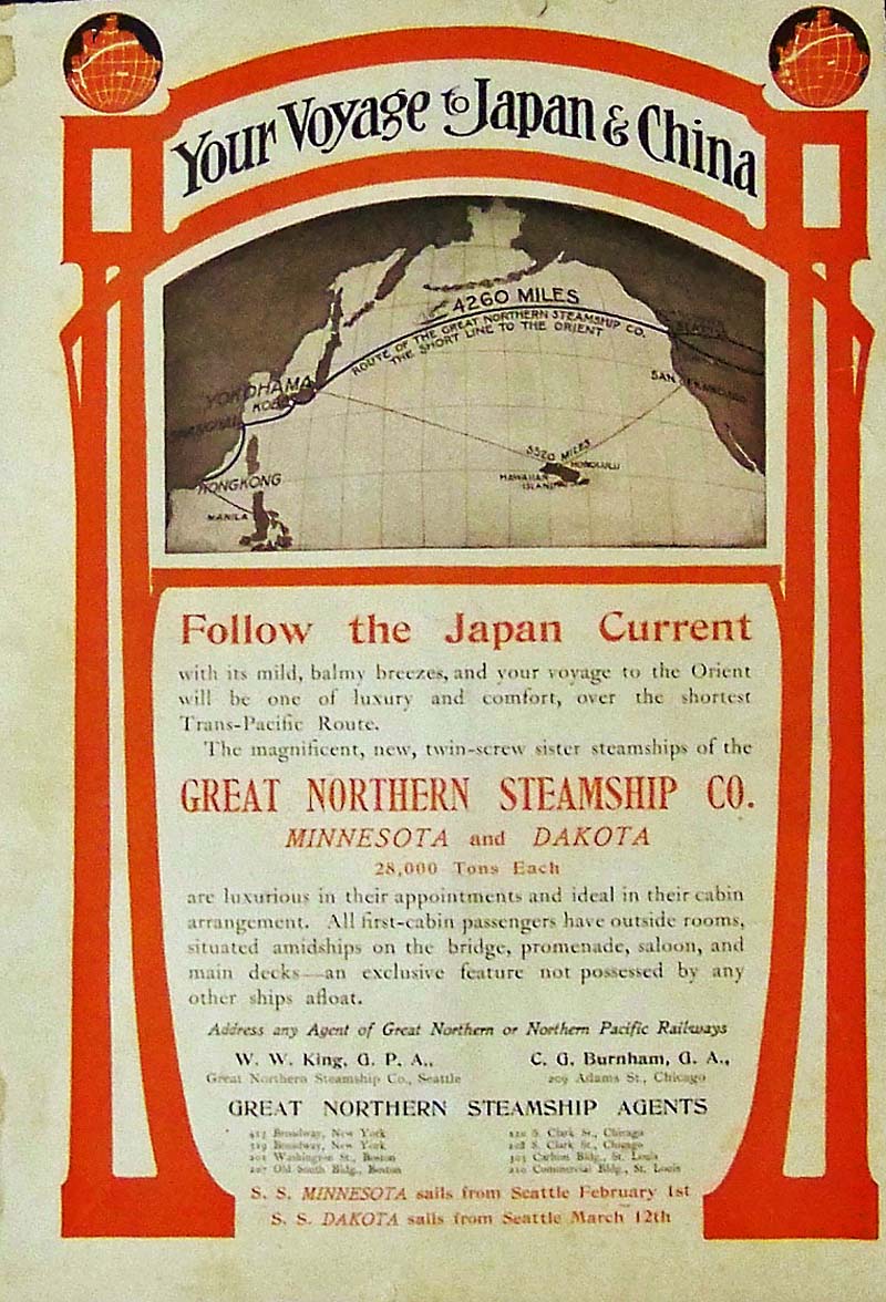
234Hawaii:
1902 Color advertisement for the Great Northern Steamship Company
detailing "Your Voyage to Japan & China, as you follow the
Japan Current with its mild, balmy breezes, and your voyage to the
Orient will be one of luxury and comfort, over the shortest
Trans-Pacific Route."
13-1/2 x 9 in. $40
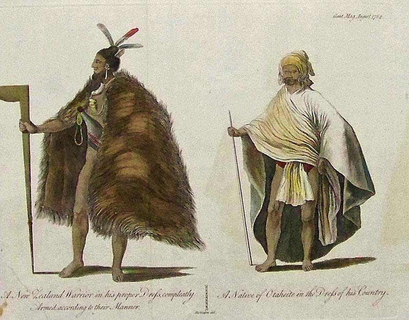
236Hawaii:
1784 Hand colored copper engraving A New Zealand Warrier in his proper
Drefs, Compleately Armed, according to their Manner; and a Native of
Otaheite in the
Drefs of his Country.
10 x 8 in. $100
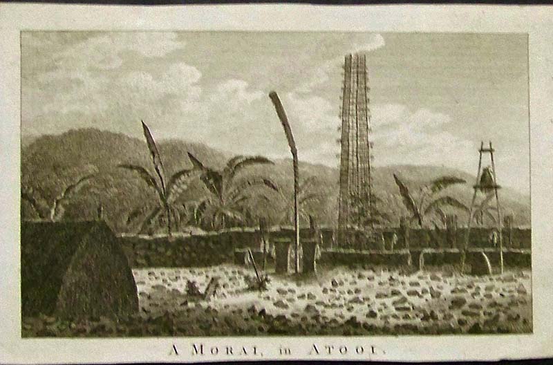
237Hawaii:
1784 Morai in Atooi (Kauai) copper engraving by John Webber, artist and
Leperneret as engraver. Part of Captain Cook's expedition.
7-1/4 x 4-1/2 in. $60
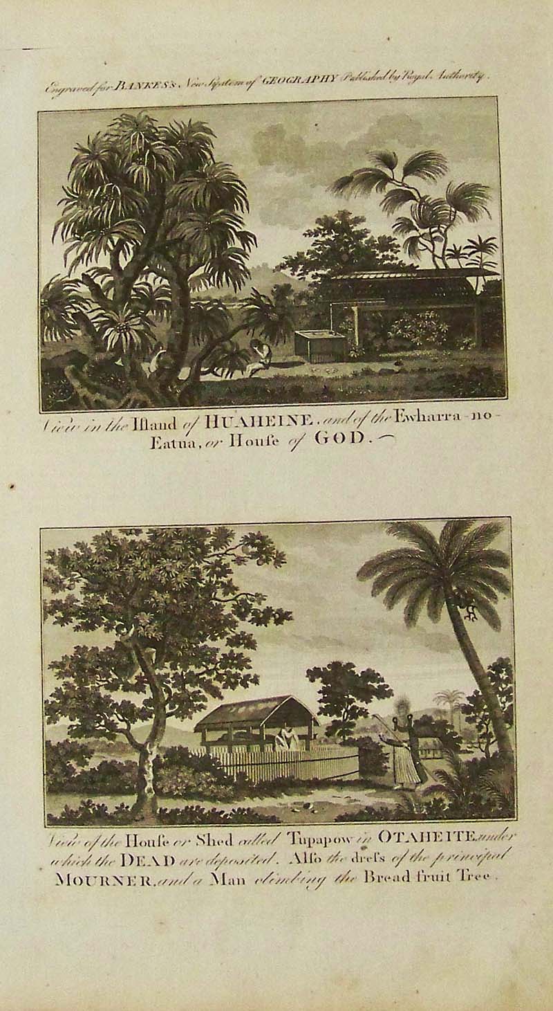
238Hawaii:
1798 Copper engravings engraved for Bankes's New System of Geography,
published by Royal Authority. Top image shows a View in the Island of
Huaheine, and of the Ewharra-no-Eatua, or House of God. Bottom image
includes a Man climbing the Bread-fruit Tree.
15 x 9-1/2 in. $120
241Hawaii:
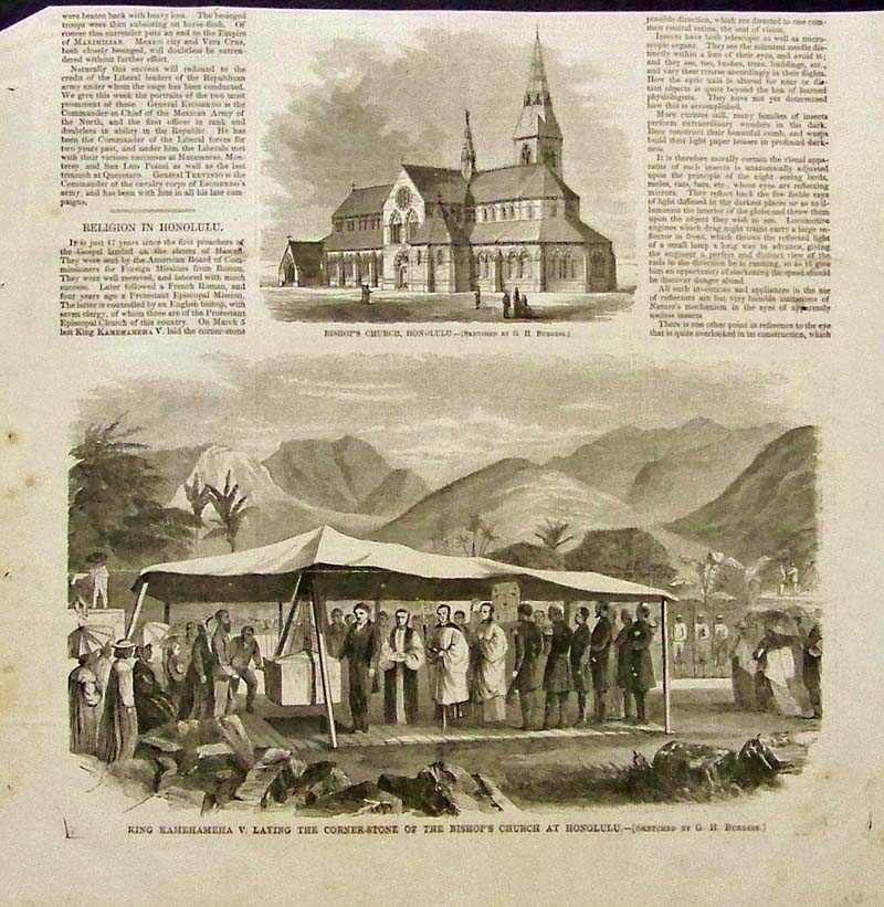
Half-page wood engraving showing Bishop's Church in Honolulu in upper
image and King Kamehameha V. Laying the Corner-Stone of the Bishop's
Church at
Honolulu in lower image.
11-1/2 x 11 in. $30
242Hawaii:
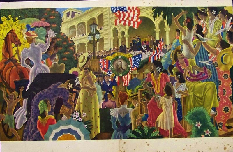
1953 Rare Matson Lines dinner menu on inside cover and outside, opened
all the way, image reveals a colorful celebration for when Hawaii
became annexed as part of the Territory of the United States on August
12, 1898. The ceremony took place on the balcony of Iolani
Palace in Honolulu.
21 x 13-1/2 in. $160
243Hawaii:
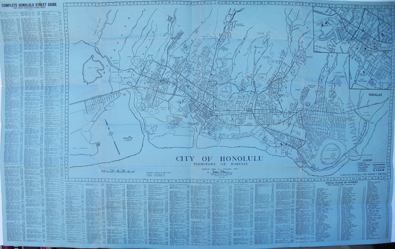
1942 Light blue engraved City of Honolulu, Territory of Hawaii map with
a surrounding key for Special Places of Interest.
34 x 21 in. $160
Check
for Availability
246Hawaii:
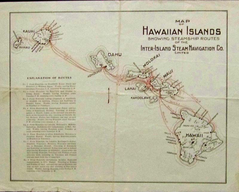
Color Map of the Hawaiian Islands, Showing Steamship Routes of the
Inter-Island Steam Navigation Co., Limited. Island on upper left is
Nihau, then Kauai, the Oahu, then Molokai, Lanai, Maui, Kahoolawe, then
the largest island on the right is the big island of Hawaii. An
Explanation of Routes key
is on left side.
12-1/2 x 9-1/2 in. $90
247Hawaii:
C.1940 Color Map and Guide showing the City of Honolulu and the
Kamehameha Dynasty. Issued by the Hawaii Tourist Bureau that gives
sightseeing by trolley tips and places to go and how to see them.
17 x 7 in. $80
248Hawaii:
C.1940 Engraved map compiled for the Hawaii Promotion Committee by E.A.
Southworth, C.E. showing the City of Honolulu. Index key at left
showing banks, parks, schools, steamship agencies, hotels, Churches,
and other
important locations.
21 x 9-1/2 in. $100
249Hawaii:
1947 Light pink engraved map showing the City of Honolulu, Territory of
Hawaii with a Complete Honolulu Street Guide (and what the Hawaiian
Names Mean).
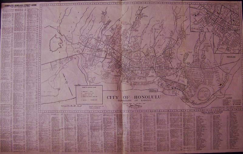
34 x 21 in. $150
252Hawaii:
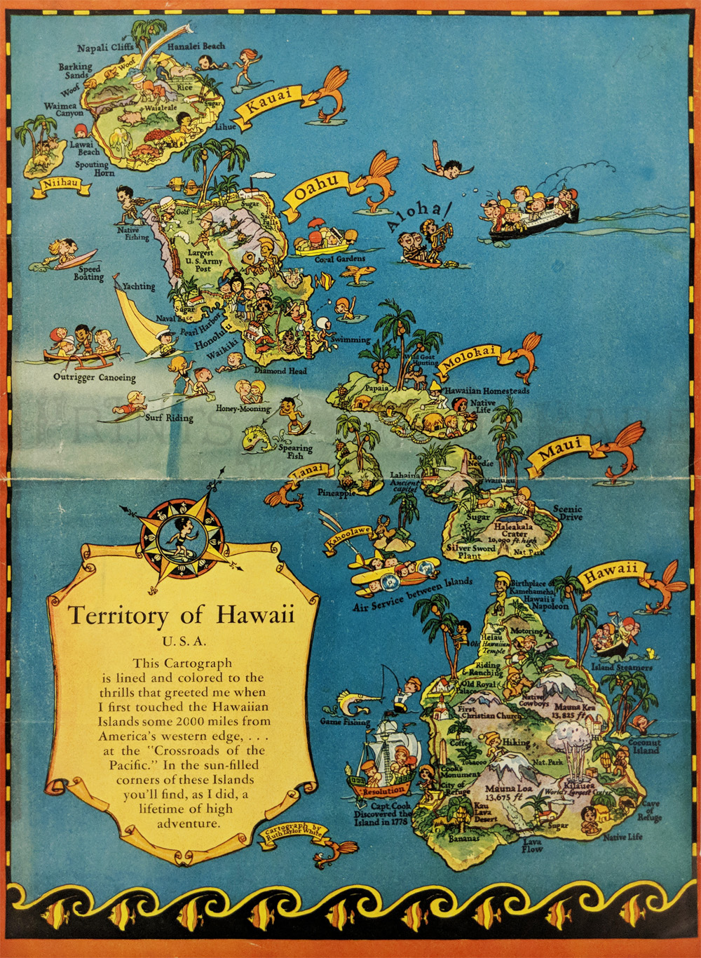
Pictorial
Map "Territory of Hawaii" by Ruth Taylor White. 1935. Humorous language
tips on verso.
11 1/8 x 8 1/4 in. $90
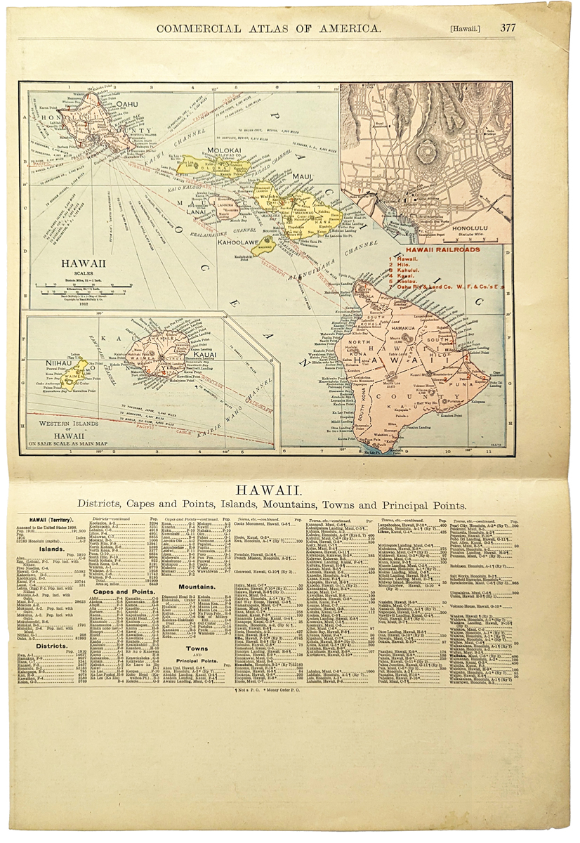
258Hawaii:
Commercial
Atlas of America. Hawaii - Districts, Capes and Points, Islands,
Mountains, Towns and Principal Points. 1912 Rand McNally.
14 1/4 x 20 1/2 in. $100
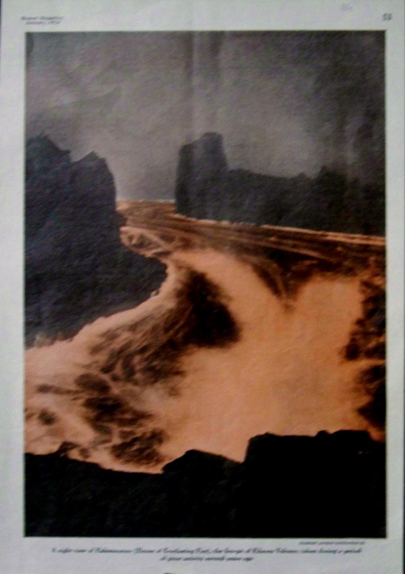
025ndis: Half-tone
portrayed in Sunset Magazine in January, 1926 shows "A night view of
Halemaumau (House of Everlasting Fire), the Fire-pit of Kilauea
Volcano, taken during a period of great activity several years ago."
11 x 7-1/2 in. $20
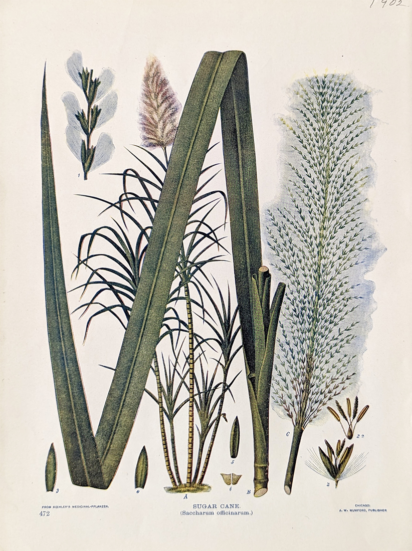
014sugar:
Sugar Cane (Saccharum officinarum). 1902 Birds & Nature. A. W.
Mumford, Chicago.
7 1/8 x 9 3/4 in. $80
See Also:
Hawaiian
Flowers
|
|