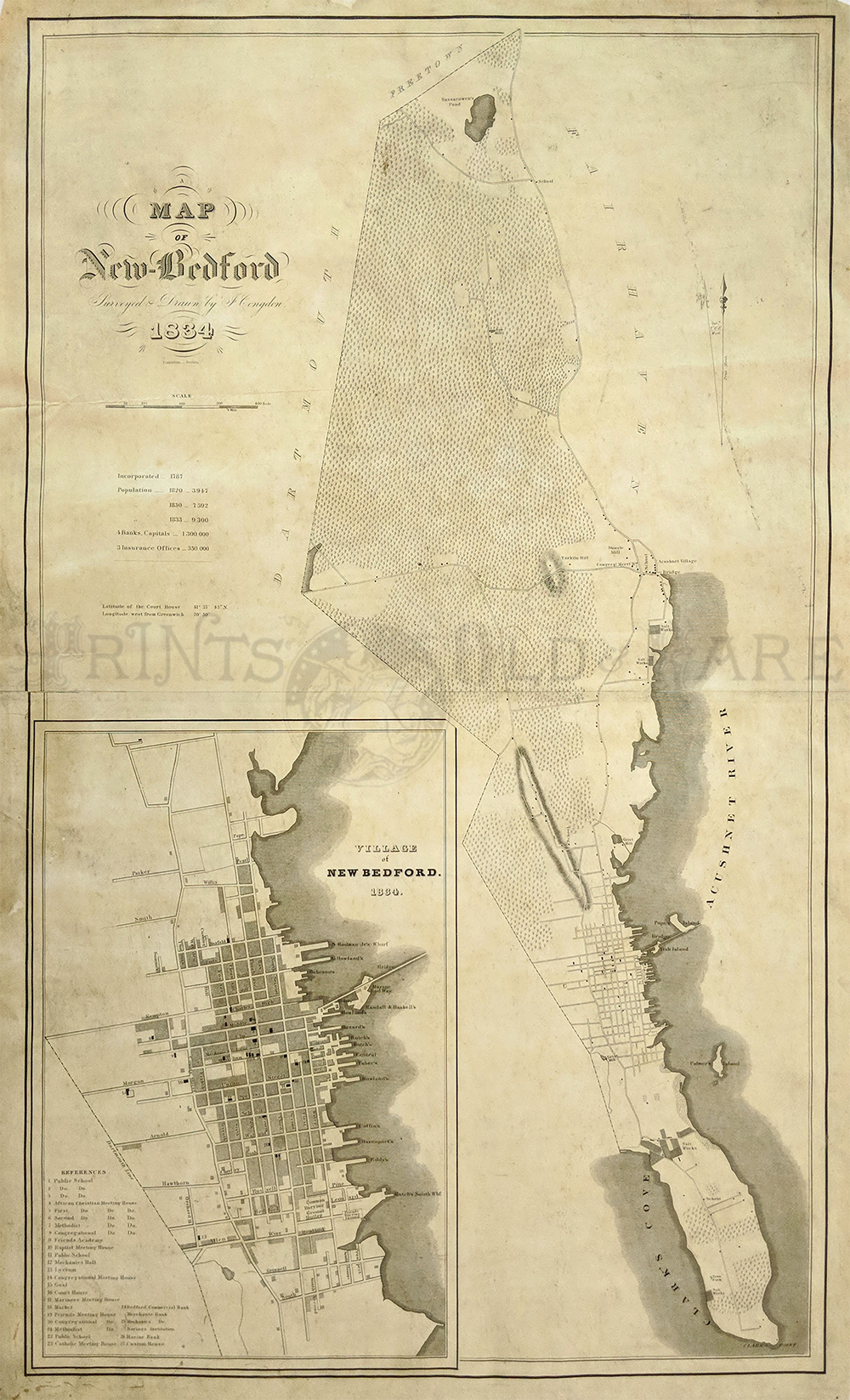
000rare:
1834 New Bedford
with large inset of its Vicinity. Very rare lithograph by J. Congdon,
published by Pendleton's Lithography, Boston. Map includes Village of
New Bedford with public buildings, roads, cemeteries, churches, plan
and waterfront docks, population and more.
Condition: Good. Browning and aging throughout with small margins, and
foxing throughout.
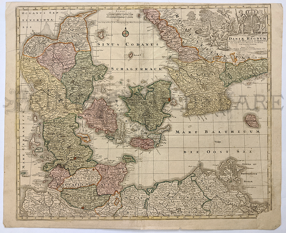
34 x 21 in. $2,500
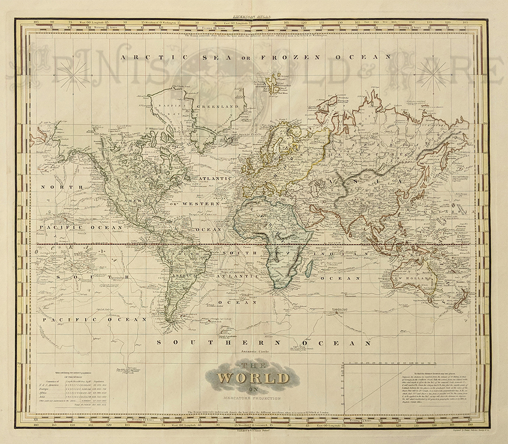
010rare:
1823 Map of the World. Published edition of Henry
Tanner's American Atlas. The map is titled "The World on Mercator's
Projection." While the names of individual countries are shown, Tanner
focuses mainly on the physical world with little emphasis on political
borders. Of particular interest in this map is the inclusion
of 18th century explorers' routes (shown as dotted lines), and the
dates of each expedition. A table in the lower left corner gives the
estimated sizes of five continents-Europe, North & South
America, Africa and Asia--as well as their populations.
Paper size is 23x30 inches,
and image size is 19x21 inches.
$500

247fra:
1583 Brittany, France. First Printed Chart of Brittany's Northern
Coastline. This rare, beautiful chart is titled "Verthoninghe van de
Zee Custen Van Bretaignen." It was published by Dutch cartographer L.J.
Waghenaer in his 1583 "Spieghel Der Zeevaerdt." In addition to being
historically significant, it is also extremely decorative. The
chart title and scale of distances are surrounded by intricate designs.
This chart is in excellent condition,
and has been
beautifully hand colored.
15x21 in. $2,500
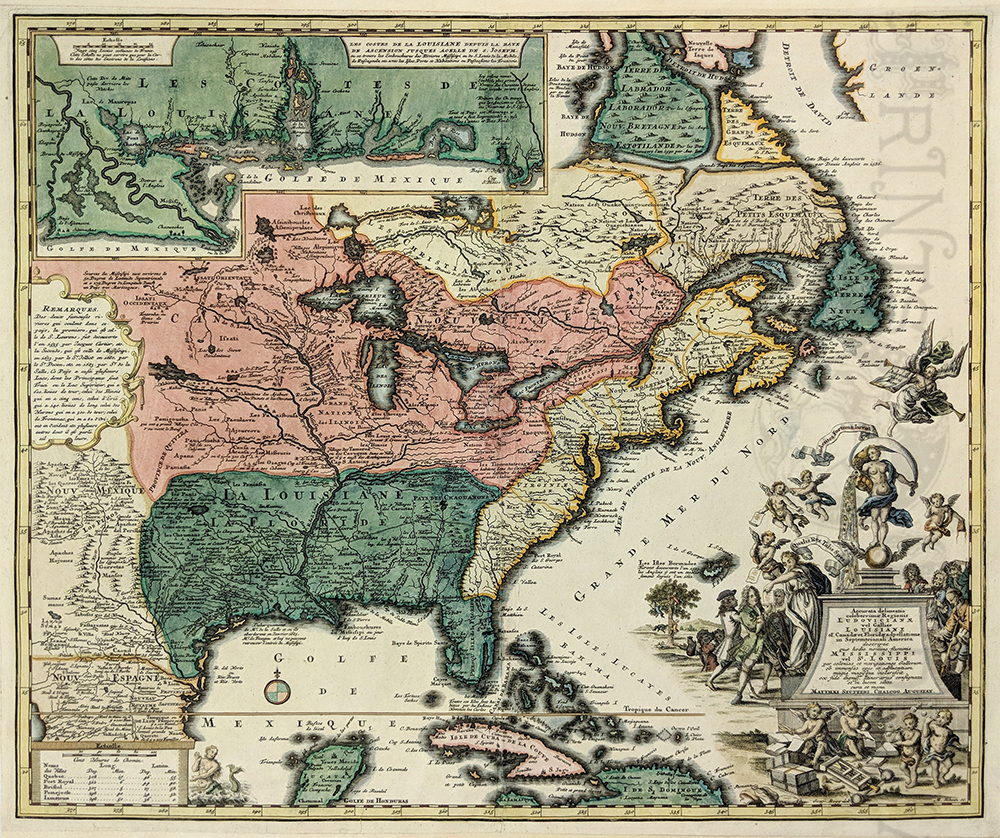
019rare:
1730 North America Map with Inset of Gulf Coast, & "Mississippi
Bubble" Cartouche. This fascinating map, published in 1730 by Mattheus
Seutter, is titled "Accurata delineatio celeberrimae Regionis
Ludovicianae vel Gallice Louisiane ol. Cauad' et Floridae adpellatione
in Septemtrionali America." This map is in very good condition with
original hand coloring.
Size is 19.5 x 22 in.
$2,900
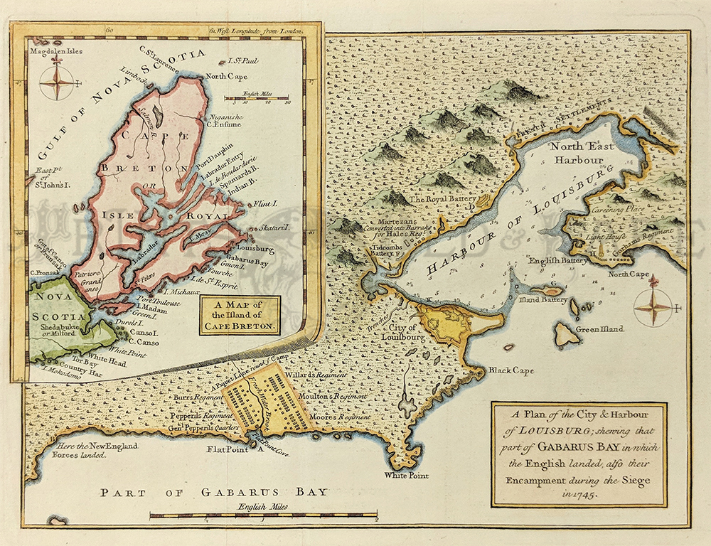
026rare:
1758 Louisburg "A Plan of the City & Harbour of
LOUISBURG; shewing that part of GABARUS BAY by Grindley. The inset map is titled, "A Map of the Island of
Cape Breton." There is a border to this section of the map showing
latitude and longitudes and the lower right corner of the inset is
beautifully drawn to look like the page is curled.
7.5x10in $120
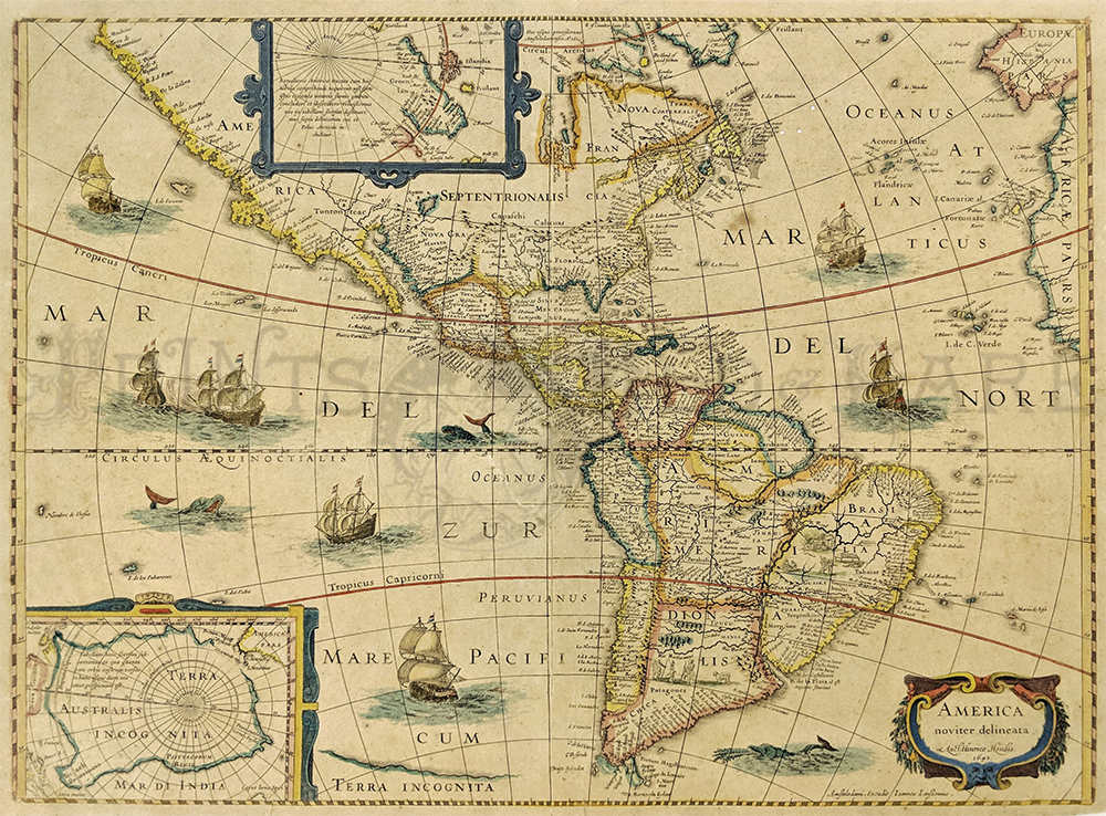
027rare:
1641 World Map. America Noviter Delineata, which shows the Western
Hemisphere and is made by Henricus Hondius. The map's localities are
the Americas and the Pacific and Atlantic Oceans. This is one of six
oldest printed maps of the Americas. Two small vignettes in the
interior of South America appear to show us Europeans meeting a native
king, and in Brazil, a small party of cannibals. Map is in very good
condition. Hand colored copper-engraved.
20-3/4 x 16-3/4 in.
$2,800
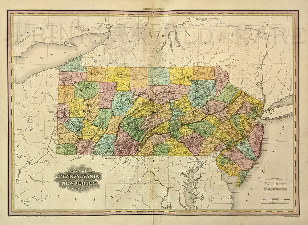
032rare:
1823 Pennsylvania and New Jersey from H.S. Tanner's American Atlas. The
figures near each county town denoted its distance form the State
capital. The figures at the State capitals, denote their respective
distance form Washington." The border has latitude and longitude marks.
30.75 x 23 in.
$1,200
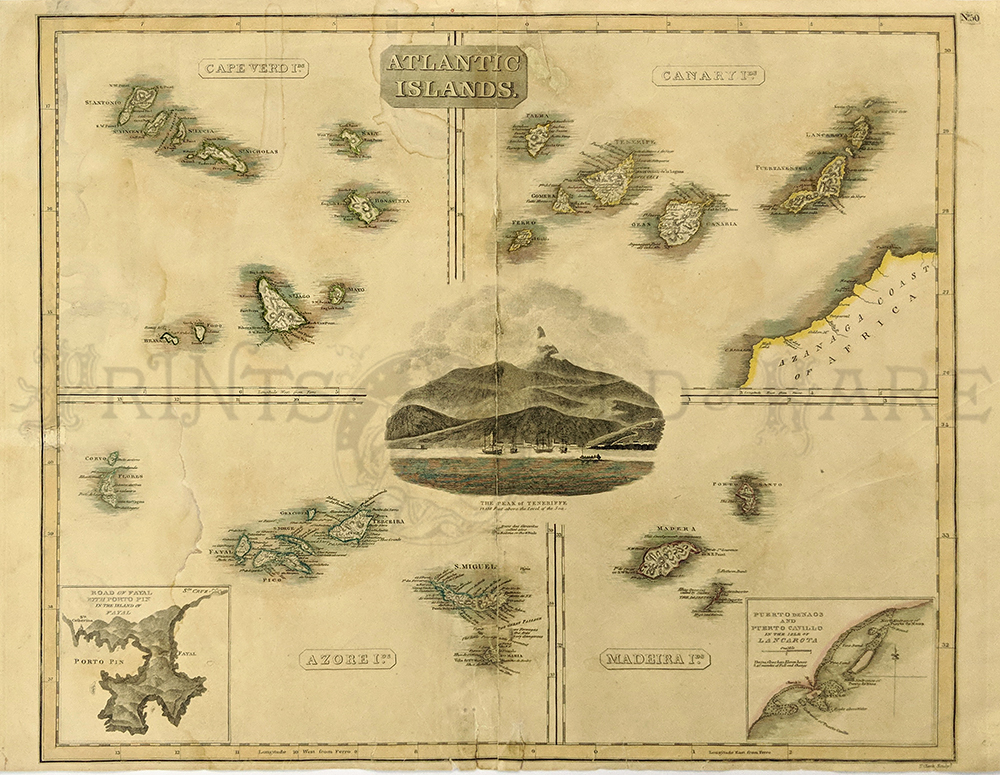
035rare:
1814 Atlantic Islands. This map has its original hand coloring and is
divided into four sections: Canary Islands, Cape Verdi Islands, Azore
Islands and Madeira Islands. The Azore Island map has an inset of the
Island of Fayal and the Madiera Island map has an inset of the Isle of
Lancarota. There is a lovely engraving of the Peak of Teneriffe in the
Canary Isles in the center of the map. Published
by Thomson.
19x22 in
$500
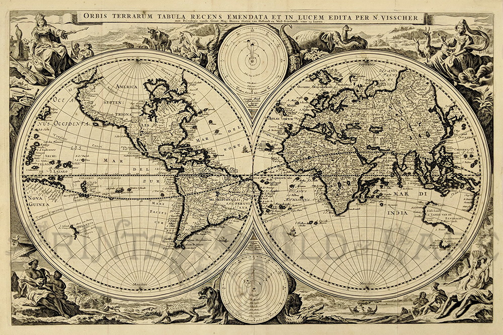
036rare:
1663 World Map. "Orbis Terrarum Tabula Recens Emendate et in
Lucem Edita Per N. Visscher," by map maker, Nicholaus Visscher in
Amsterdam. This hand colored double-hemisphere map of the world, which
includes many of the great seventeenth century cartographic myths and
errors. The directional symbols rest top and bottom center of
double-hemisphere. Map is in
very good condition.
18-1/2 x 12 in.
$3,000
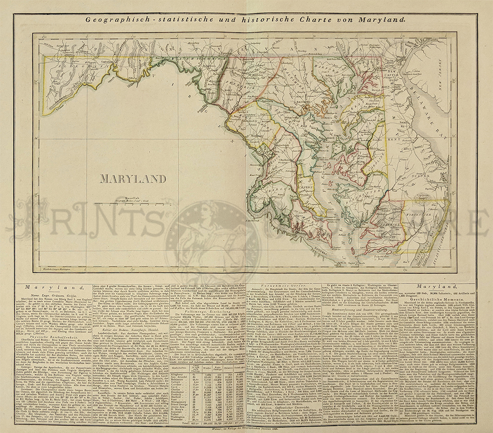
038rare:
1826 Maryland. German
map with
geographic and historic information done by "Weimar, im Verlages des
Geographischen Instituts." This map has its original hand coloring with
each of the counties outlined in a different color. County names are
included as well as rivers and many cities across the state. Chesapeake
Bay is shown in detail with all of the inlets and islands.
20.5x25in $400
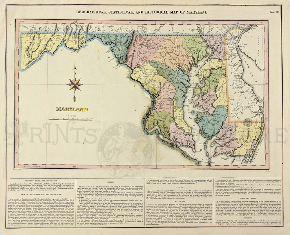
050rare:
1826 Maryland. ANTIQUE
MAP OF MARYLAND - 1823. Hand colored engraved map produced in 1823.
Indiana is centered with important historical, statistical and
geographical information about the state. Roads, rivers and counties
are all shown as well as Baltimore, Annapolis, Washington D.C. and
Cypress Swamp. Carey & Lea are the cartographers. Condition is
good, two archivally repaired holes along originally centerfold near
rivers edge.
17.5 x 22 in. $650
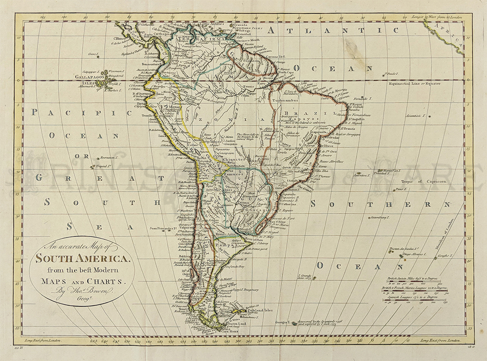
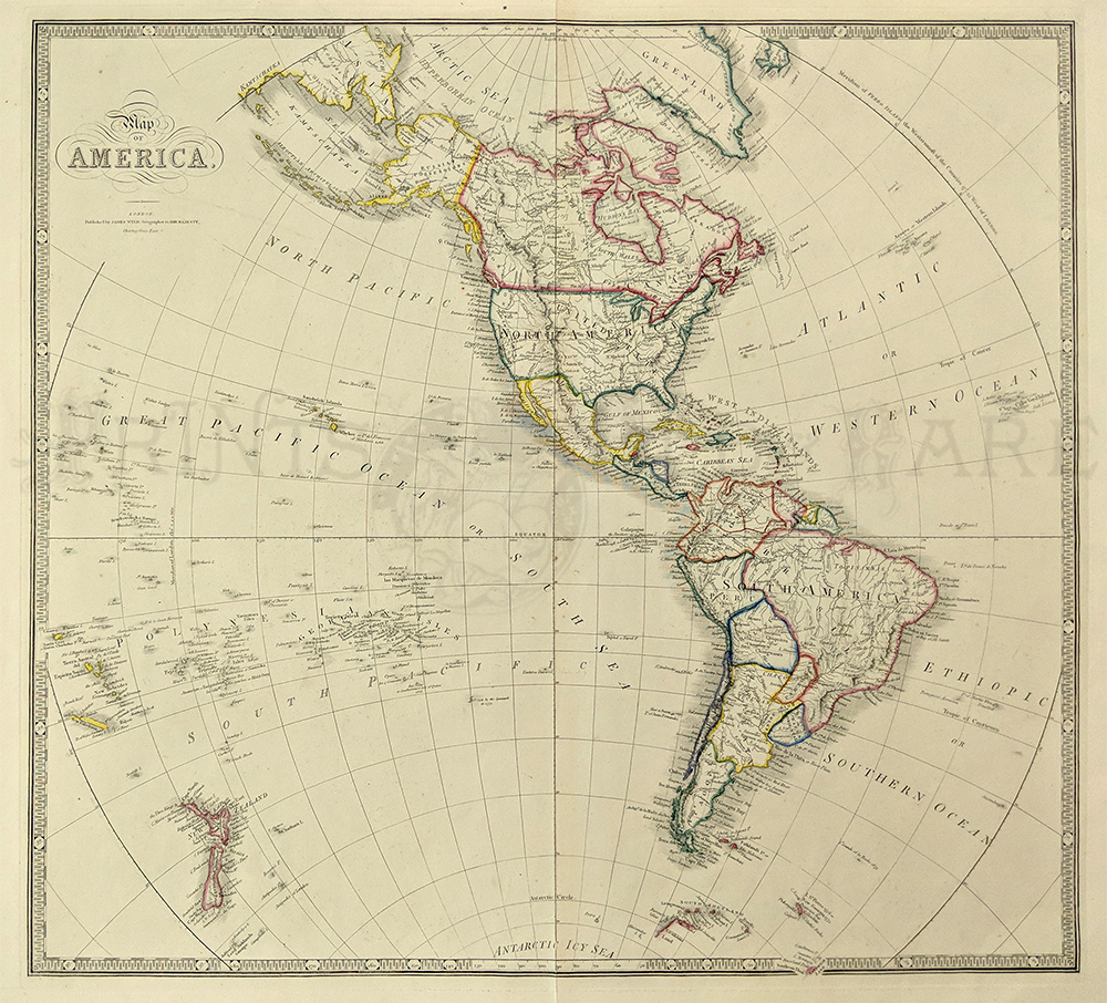
051rare:
1787 South America. "An Accurate Map of Sosuth America from
the best Modern Maps and Charts by Thomas Bowen, Geographer. It has
curved longitudinal lines. The Pacific Ocean is also listed as "The
Great South Sea". Individual countires are outlined in different colors
with ports,major cities rivers and mountains marked. Many
islands are also listed.
15x19.5in. $150
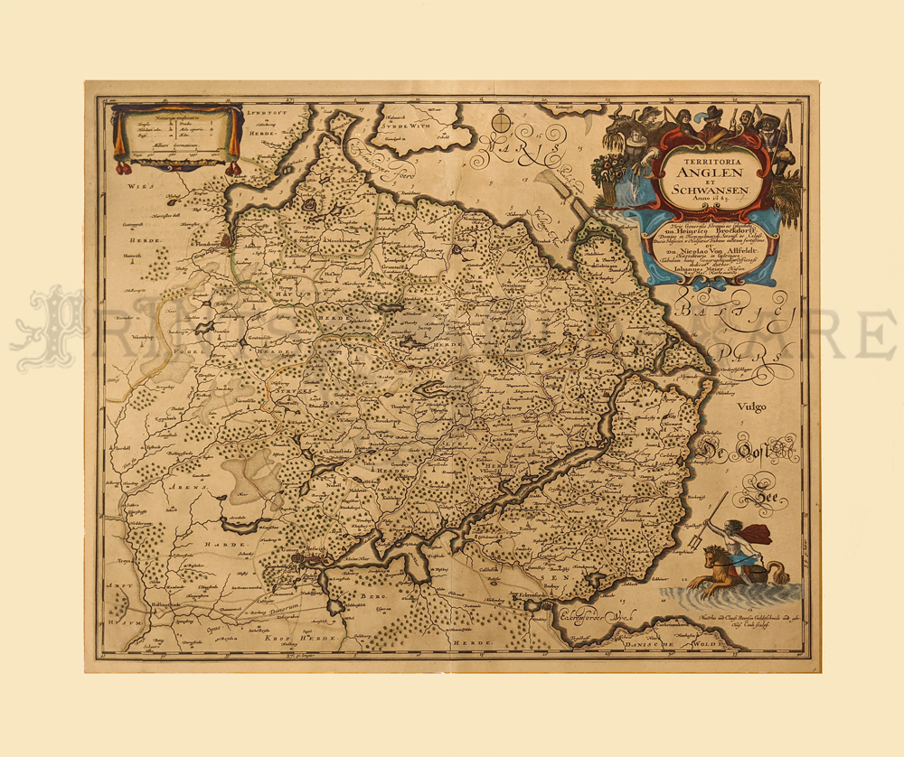
236ger:
Anglen & Schwansen (Northern Germany) Blaeu 1649. Copper
engraving with original old color. Map is evenly toned. Beautiful
cartouche and sea.
20 x 24 in. $250
302us:
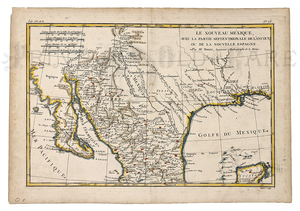
Le Nouveau Mexique 1780 by R. Bonne. Shows West from Florida to
California. Hand colored, copper engraving. Shows Missions,
Settlements, Indians, and Rivers.
10 x 14 1/8 in. $350
Check
for availability
245fra:
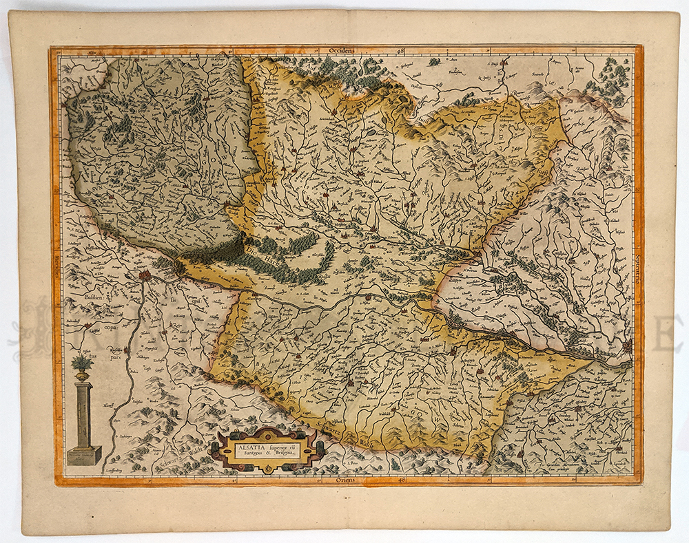
Alsatia 1614 Mercator (Hondius) - Hand colored copper engraving shows
Rhine River from Strasburg to Basle, towns, forests and mountains.
14 x 19 in. $400
238ger:
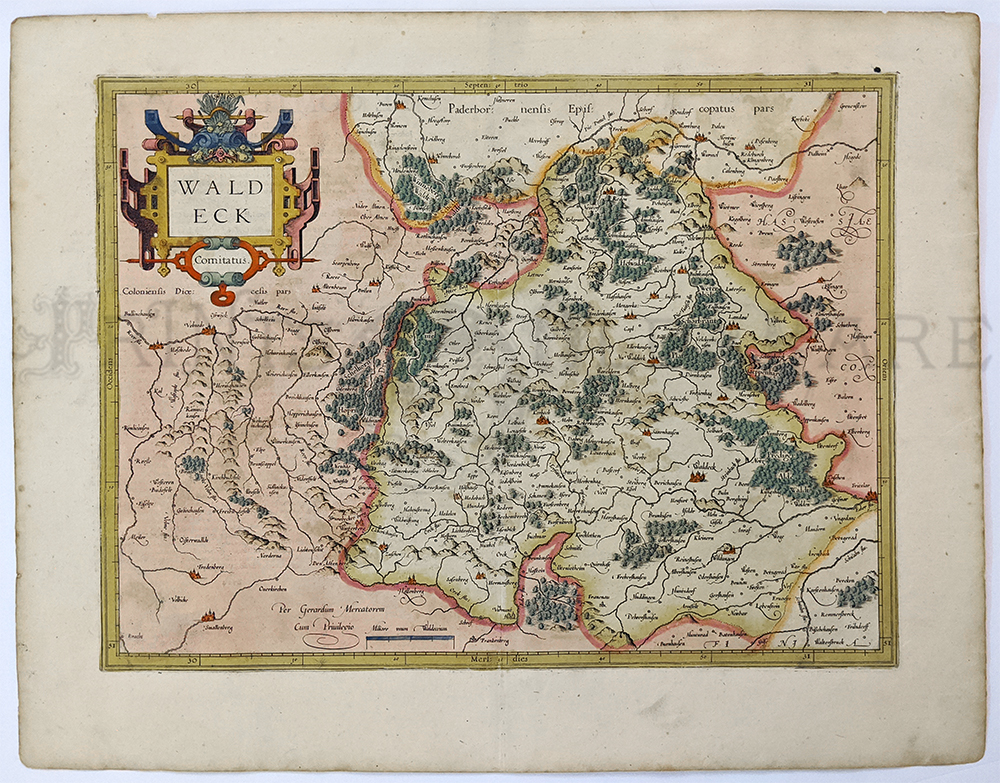
Waldeck c.1620. Hand colored copper engraving topographical map showing
forests, towns, rivers. Fine condition.
14 x 18 in. $225
008den:
Daniae Regnum cum Ducatu Holsatia. M. Seutteri c.1730. Hand colored
copper engraved map of Demark and Southern Sweden, esp Germany. *Bottom
corner patched.
20 3/4 x 24 3/4 in. $350
044scandanavia:
Sweden: Regni Gothiae 1680 by F. De Witt. Hand colored copper engraving
detailed map showing Islands, lakes, and rivers. Cartouche.
Mat size: 23 x 27 in. / Image: 16 3/8 x 20 in. $350
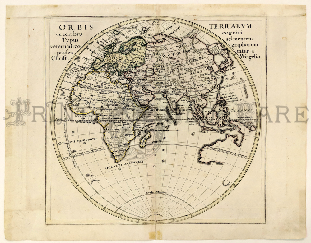
241ma:
Edgartown Harbor and Cotamay Bay 1872. Antique map of this Martha’s
Vineyard location. Original U.S. Coast Survey Map, showing soundings,
and water warn sections.
21 1/2 x 31 in. $475
212low:
Kennemaria et Westfrisia vulgo et vernacular Noord-Holland. c.1680 by
Visscher. Wonderful detailed map of Northern region of Holland. 2
outstanding cartouches – attractive old color.
Map: 19 x 23 in. / Frame – 27 x 31 1/8 in. $850
|
058rare:
1838 Washington, Louisville and Jefersonville, New
Orleans and Cincinnati Map. This beautiful hand colored map was done in 1838
by T. G. Bradford in the Clerk's Office of the District Court of Mass.
It is divided into four sections, each showing a major city. Detailed
streets are shown as well as divisions within the cities. There is a
simple
light green border.
15.5x19.5 in. $200
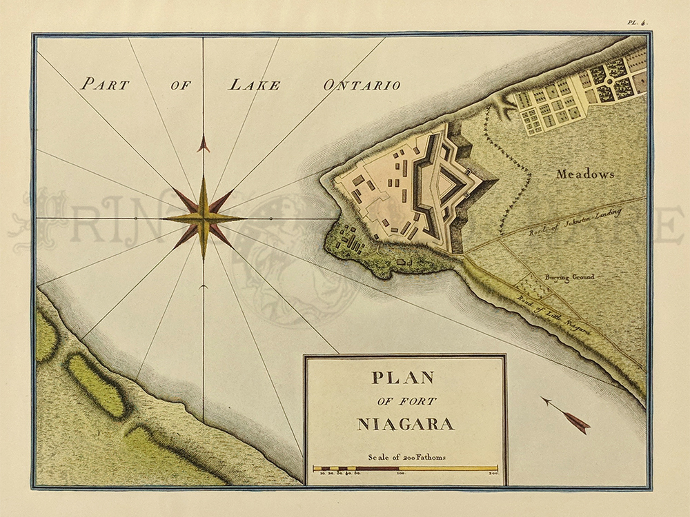
064rare:
1826 North America. Originally done in 1796 by George Henri Collot but
was not published until 1826 in the "Journey in North America..." by
Arthus Bertrand of Paris. This hand colored map shows the detailed
plans of the fort showing the nearby town and burying ground. There is
a lovely compass rose to the left. The scale for this map is done in
fathoms.
10x13 in. $300
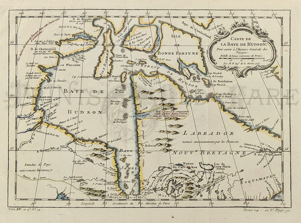
066rare:
1757 Hudson Bay and St. James Bay, Canada. Jaques Nicholas Bellin was
one of the most important and proficient French cartographers of the
mid-eighteenth century. He was appointed the first Ingenieur
Hydrographe de la Marine, and also Official Hydrographer to the French
King. In 1757 he printed this map in Paris titled,"Carte de La Baye de
Hudson pour servir a l'Histoire Generale des Voyages." It shows Hudson
Bay and St. James Bay in Canada. It has its original outline hand
coloring with a lovely engraved cartouche in the upper left corner.
10.5x15.5in. $250
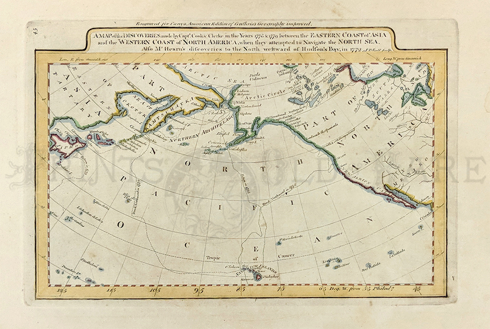
069rare:
1785 A Map of the Discoveries made by Capts. Cook &
Clerke, in the years 1778 & 1779 between the Eastern Coast of
Asia and the Western Coast of North America, when they attempted to
Navigate the North Sea. Also Mr. Hearn's discoveries to the North
westward of Hudson's Bay in 1772". This beautiful map shows the routes
of the explorers including exploration of Niohon (Japan). Originally
engraved for Hervey's New System of Geography, it is beautifully
engraved with
original outline coloring.
10.5x17in. $150
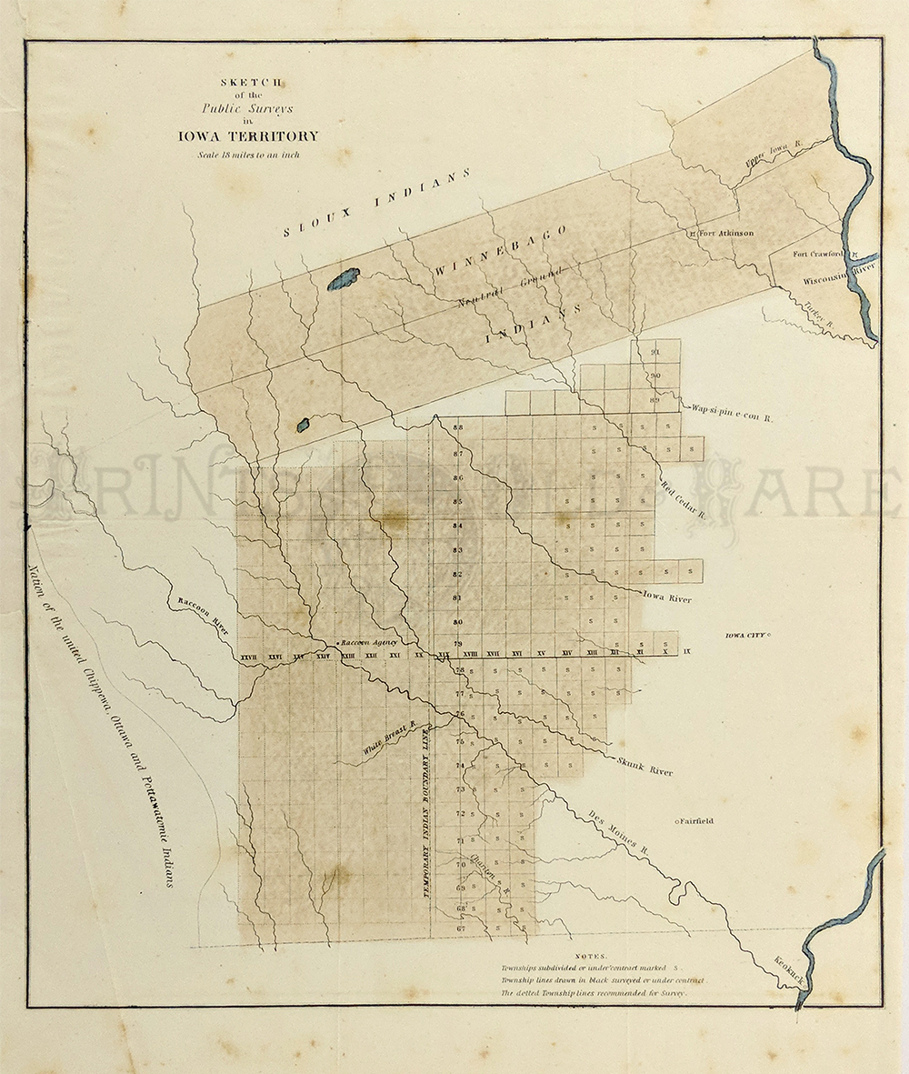
082rare:
c.1840 Iowa Territory Public Survey map. The scale of the map
is 18 miles to the inch and it covers the eastern portion of the state
along the Mississippi River. Cities marked on this map include Keokuck,
Fairfield, Iowa City, Fort Atkinson and Raccoon Agency. Many Indian
tribes are named on this map. Some shown are the Sioux, Winnebago, and
Nation of the United Chippewa, Ottawa and Pottawatomie.
Original hand coloring.
15.75x12.5 in. $300

104rare:
1780 United States. Bonne Map showing North Virginia to Maine. Hand
colored copper engraved map titled, "Carte De La Partie Nord Des E Tats
Unis De L'Amerique Septentrionale." Map enclosed in a lovely mat.
12.5 x 8.3 in. $325
105rare:
1835 North & South America. Original colored Map of America,
published by James Wyld, Geographer to Her Majesty, London.
28-1/2 x 23 in. $250

106rare:
1799 America. Showing North and South America with their Several
Subdivisions and the Newest Discoveries," published by Z. Jackson for
Paynes New System of Universal Geography. Explanation of Colours key in
bottom right corner.
Hand
colored copper engraved.
24 x 21 in. $650
109rare:
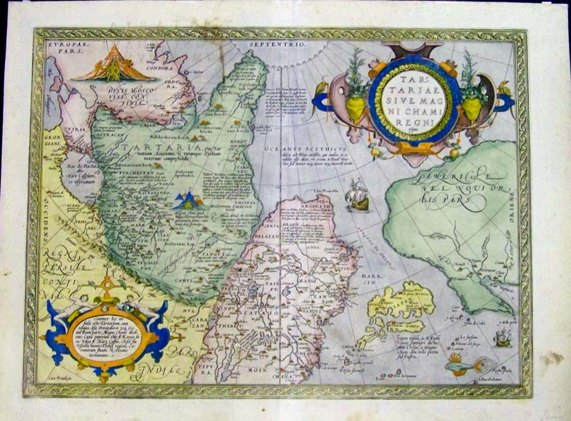
1590 Tartary, Japan and the West Coast of North America.
"Tartariae sive magni Chami regni typus." Map published in Antwerp by
Ortelius, A. Good condition except for a narrow brownish stain in upper
left Artic Ocean. Original
hand colored copper engraving. Slight
spotting on margins.
Image size: 18-1/2 x 14 in.
$1,800
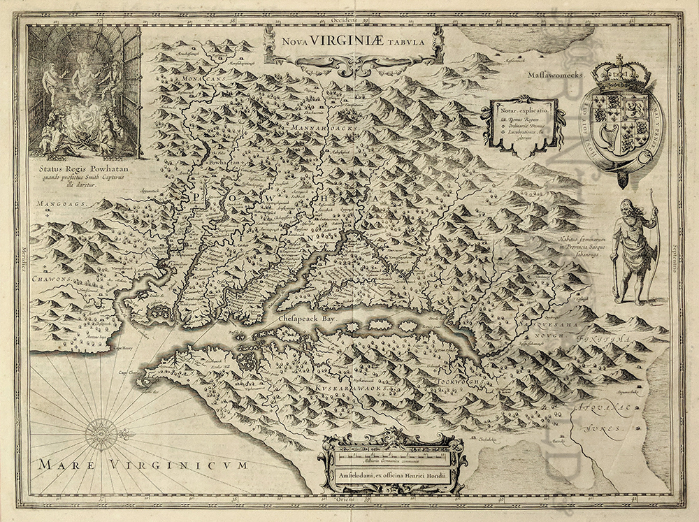
113rare:
c.1630 Virginia. Copper engraved map titled, "Nova Virginia Tabvla,"
which features the British Coat of Arms, a native Virginian (rt) facing
Chesapeake, Court of Powhatan, old native place names and details of
rivers. Map is by Henricus Hondius. Map is in fine condition and
surrounded by archival mat.
19-1/2 x 15 in.
$3,500
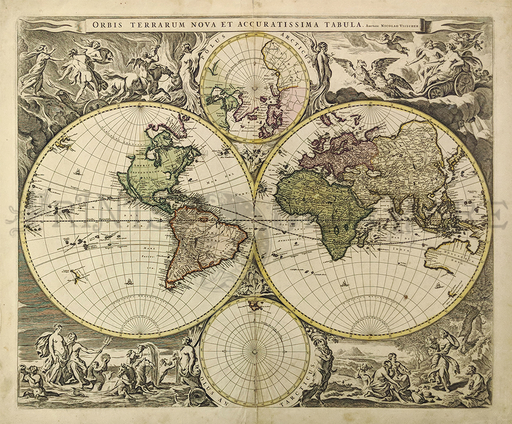
118rare:
1658 World Map. Niolao Visscher, Auctore Orbis Terrarum Nova et
Accuratissima. Amsterdam; after 1658. Copper engraved double hemisphere
world map, hand colored. Very good overall condition with a small bit
of damage in the middle center.
Measures 21 1/2 x 18 1/4"
plus margins.
$6,000
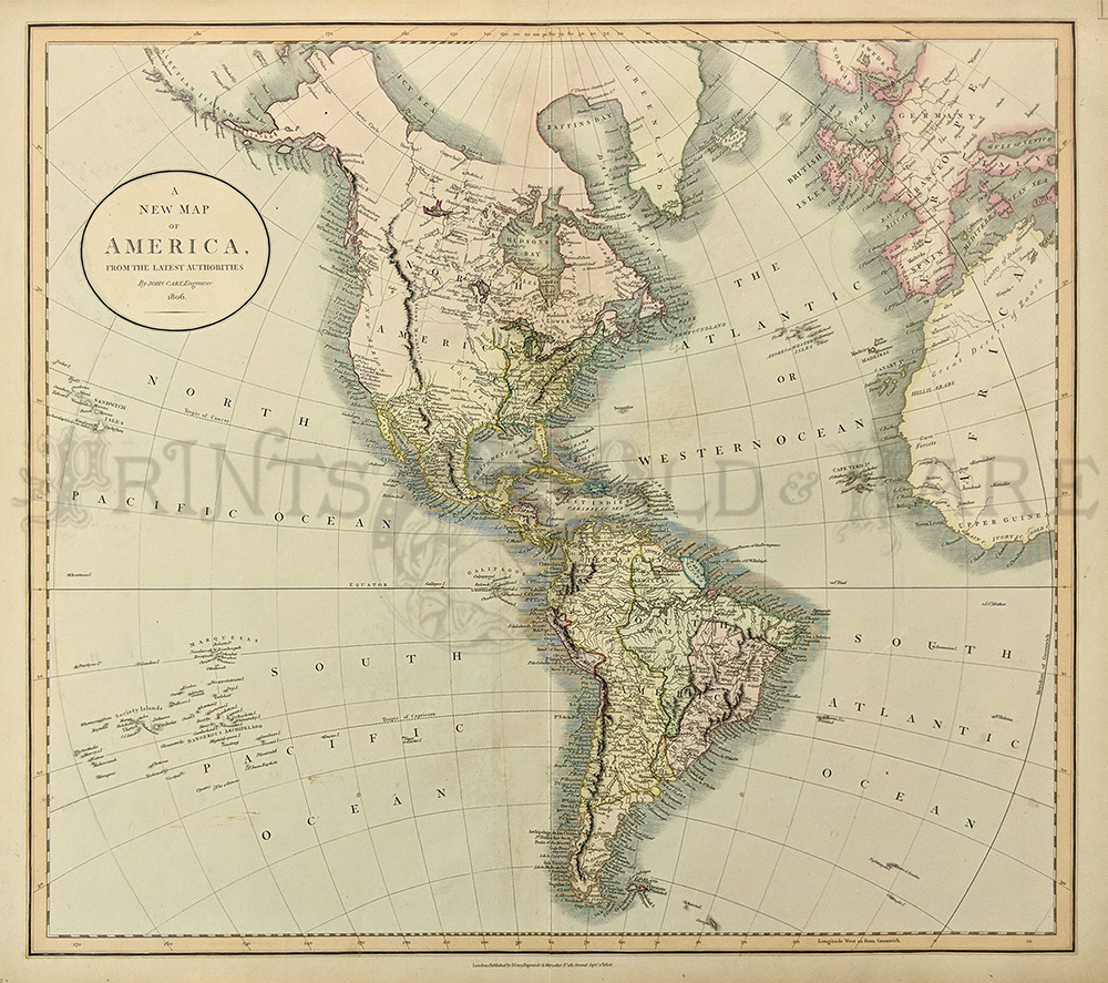
119rare:
1806 American. A New Map of America From the Latest
Authorities. Published by J. Cary, engraver and map seller, London.
Lovely water colored copperplate engraving on hand made paper.
Excellent condition.
20 1/2 x 18" plus margins.
$350
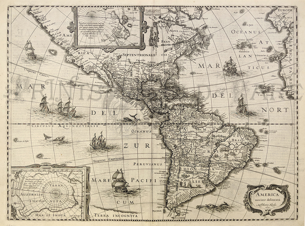
120rare:
1631 North America. Hondius America Noviter Delineata. Very decorative
map of the Americas published in Amsterdam. Showing sea creatures in
sailing ships in both the Atlantic and Pacific Oceans. Insets showing
the North and South Poles. Copperplated black & white engraving on handmade hand laid
rag. Excellent condition, printing on reverse, measuring:
19 1/2 x 15" plus margins.
$2,800
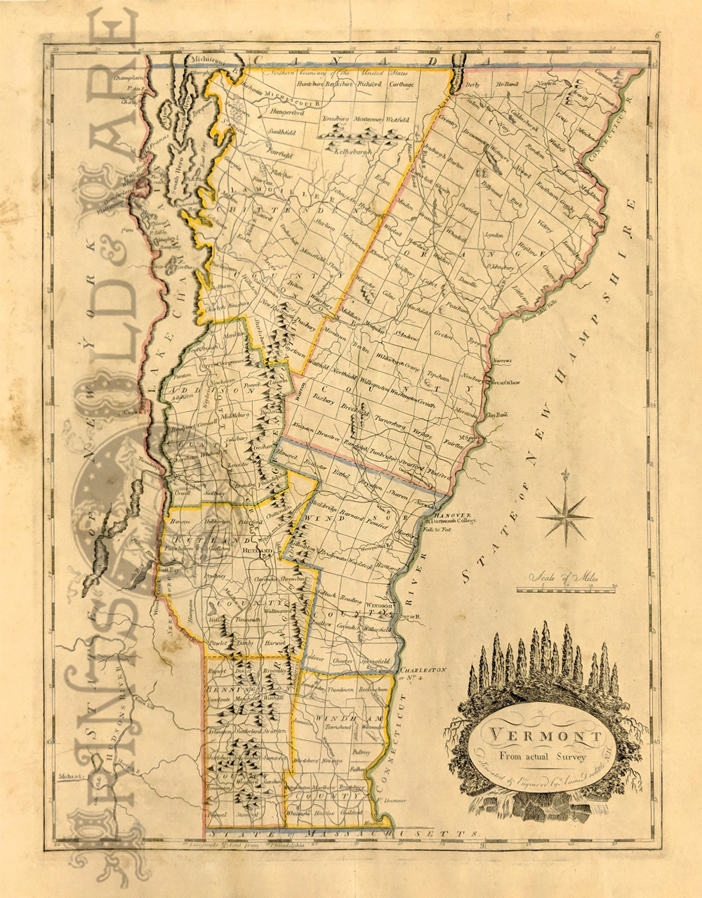
113vt:
1814 Vermont. Doolittle Map of Vermont from Carey’s General Atlas.
Counties hand outlines in color. Shows towns and property owners.
12 x 15 1/4 in. $595
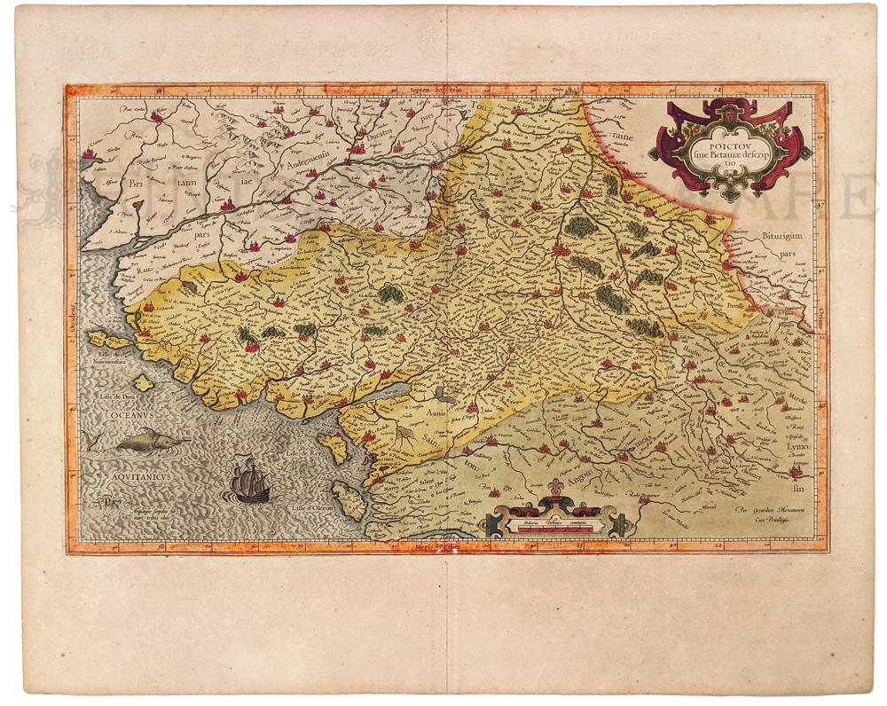
244fra:
Poictov 1613 by Mercator. Hand colored copper engraved
map of part of coast of France above Bordeaux. Map depicts ships, sea
creatures, towns, churches, river decorative cartouche.
16 x 20 in. $325
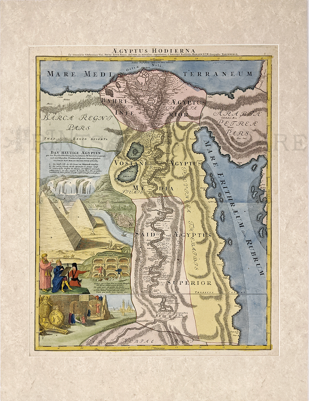
215egyp:
Egypt – “Aegyptus Hodierna” 1720 by Homann. Hand colored, copper
engraving.
20 5/8 x 24 5/8 in. $425
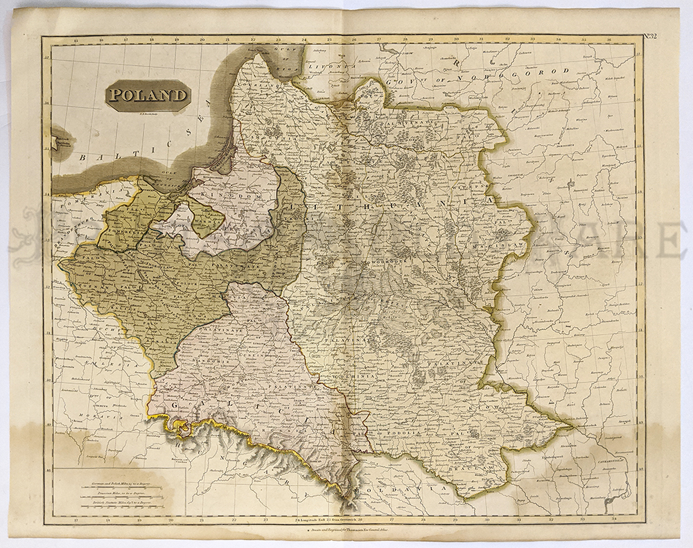
240ceur:
Poland & Lithuania 1817 by Thompson. Hand colored steel
engraving.
4th Partition of Poland - color coded to countries that controlled each
part. Relif is showin by hachure with towns, cities and major
topgraphical features identified.
20 3/8 x 26 1/4 in. $250
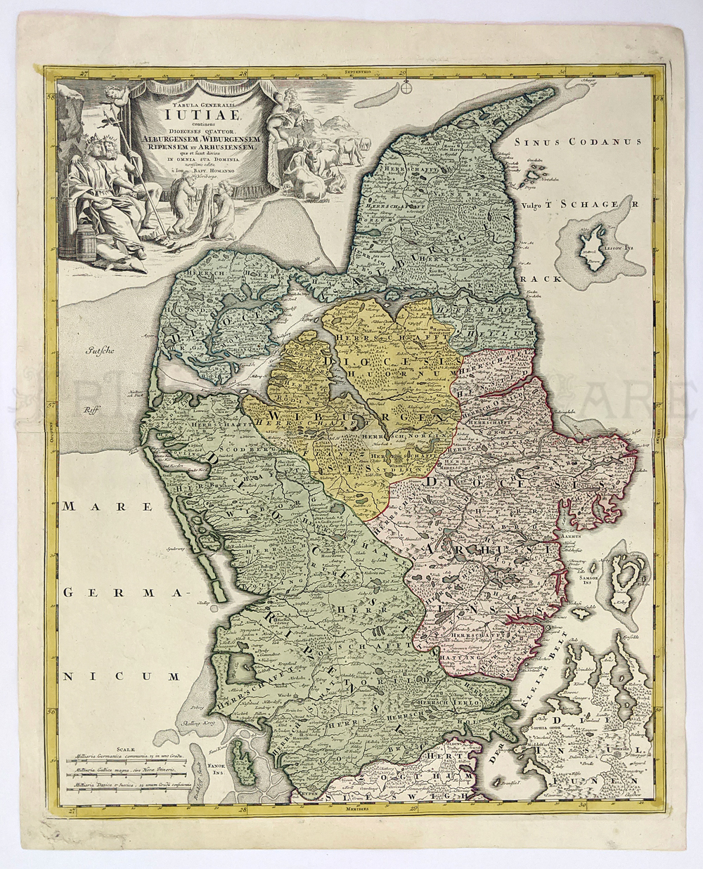
202den:
Jutland - c.1720 "Tabrela Generalis Iutaie" Northern part of Denmark by
J.B. Homann. Hand colored copper engraving.
22.4 x 19.9 in. $295
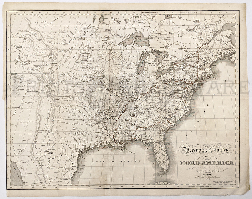
241nam:
North America Map 1828 by John Melish. German version of 1822 Map.
Engraving of US West to include all of Texas, Rocky Mountains,
Columbia, and Columbia River.
16 1/8 x 20 in. $1150
|
284ow:
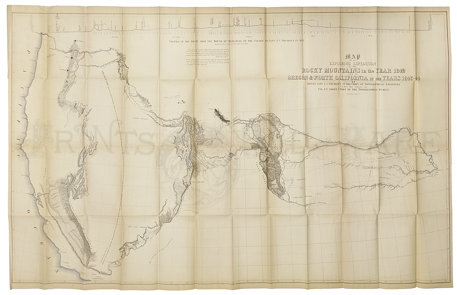
Fremont - Exploring Expedition to Rocky Mountains
1845. Fine copy of
this important map. Features top in profile - Map is whole West from
Kansas to Pacific Ocean. Oregon, Spanish Trails are shown along with
Sierra Nevada and Rivers. Also detailing the various Native American
tribes.
31 3/4 x 50 7/8 in. $1500
144rare:
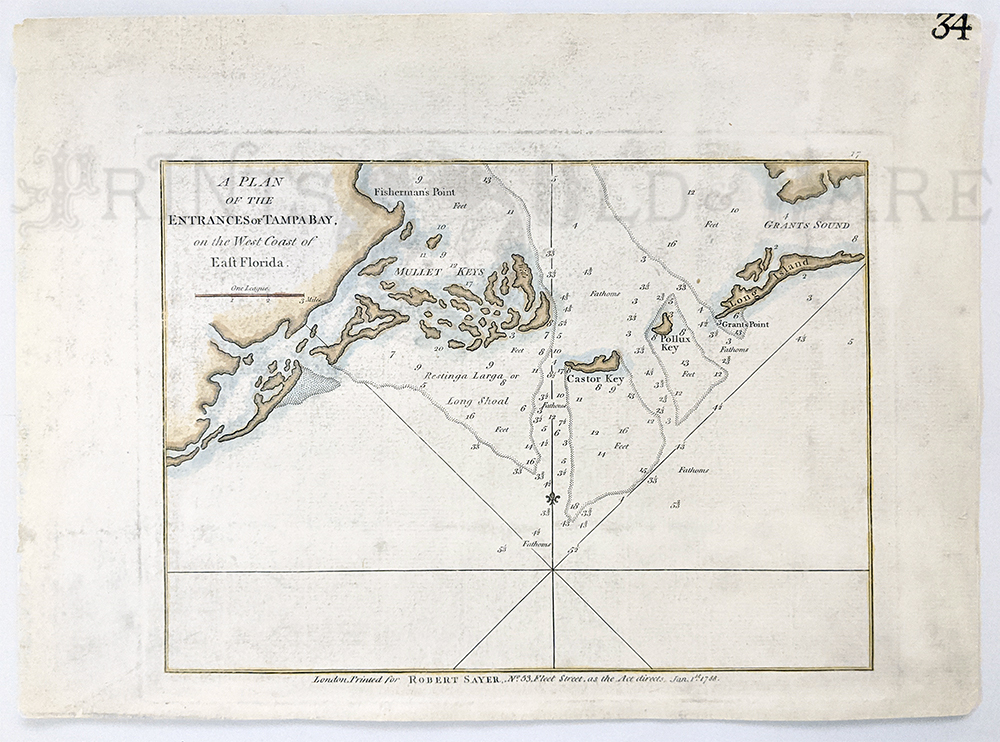
Entrance to Tampa Bay 1794 on the West Coast of
East Florida. Sayers and Bennett. Hand colored, copper engraving. Very
good condition. Shows soundings, Mullet Keys, Fisherman’s Point, Caster
Key, Pollux Key, Long Island and Grants Sound.
9 x 12 in. $950
145rare:
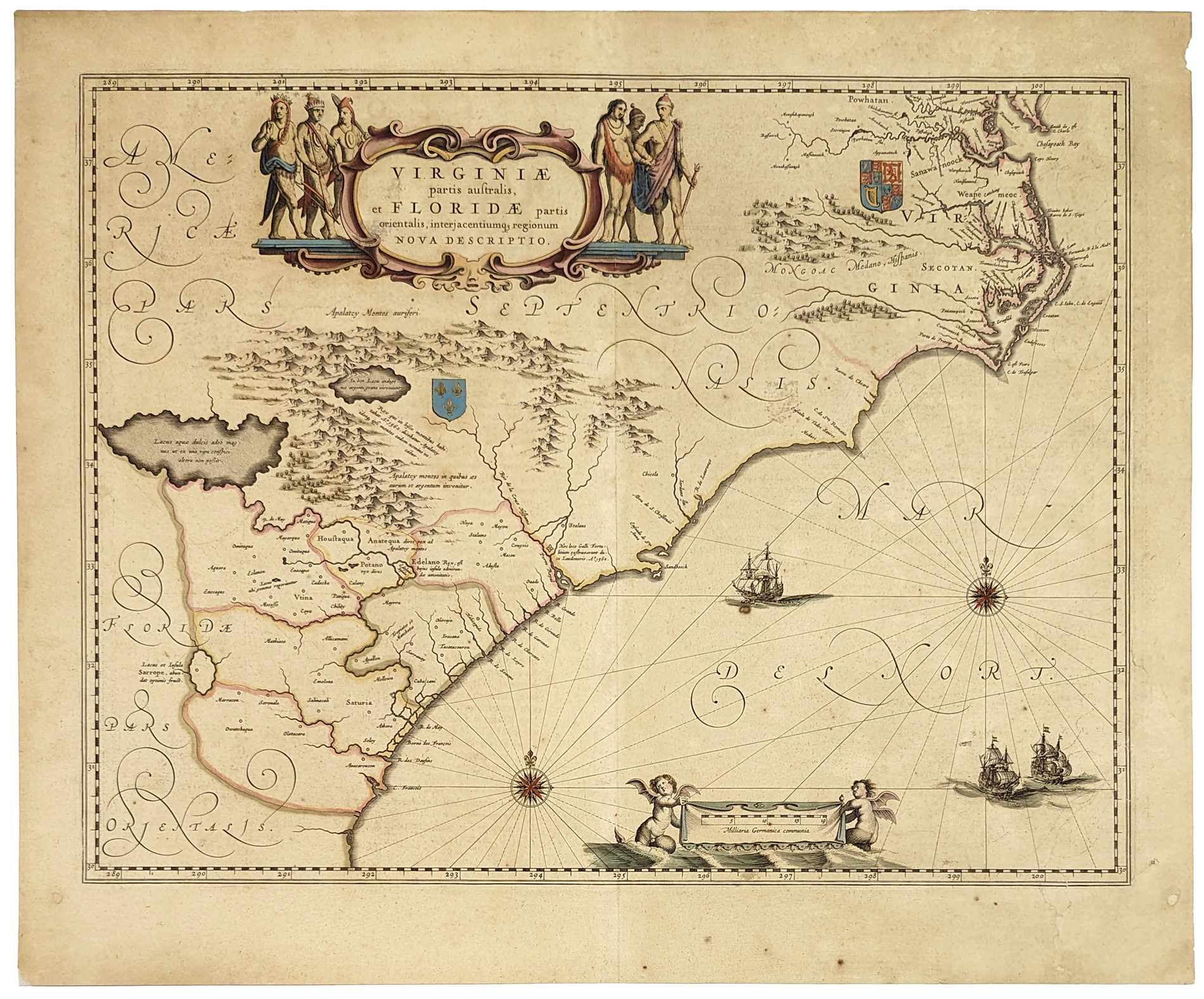
VIRGINIAE
partis australis, et Floridae partis orientalis. c.1638-1650. Beautiful
cartouche, old colours, sea ships, angles, etc. Excellent condition.
15 1/2 x 20 in. $2,200
146rare:
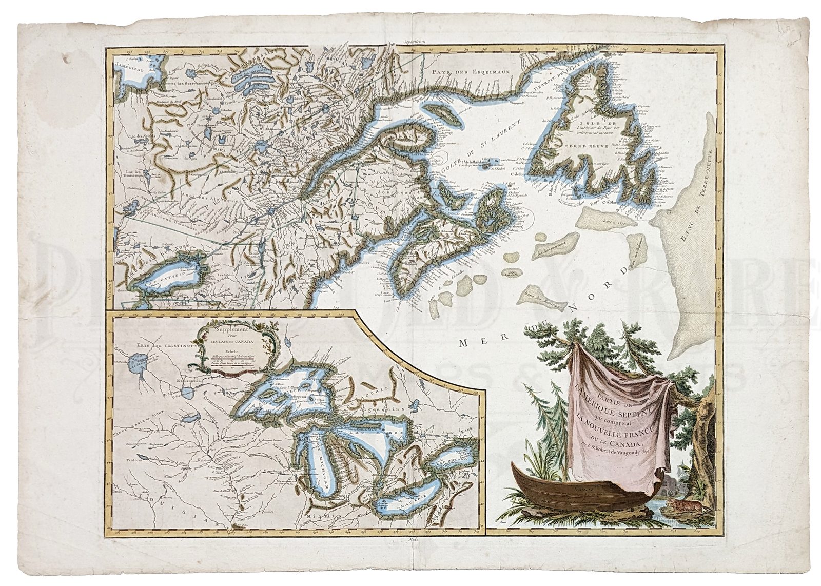
1778
Robert de Vaugondy Map of Canada, New
Foundland, Nova Scotia and the Great Lakes. Hand colored, copper
engraving. Scarce and influential map illustrating the political
situation around the Great Lakes and in Canada early in the American
Revolutionary War. Charleton Island named for the first time and
the orientation of F. de la Presqu'isle has been changed. Inset of The
Great Lakes; shows a Bellin delineation complete with the mythical
islands in Lake Superior, invented by Bellin in order that he might
name them for his patrons.
21 x 30 in. $850
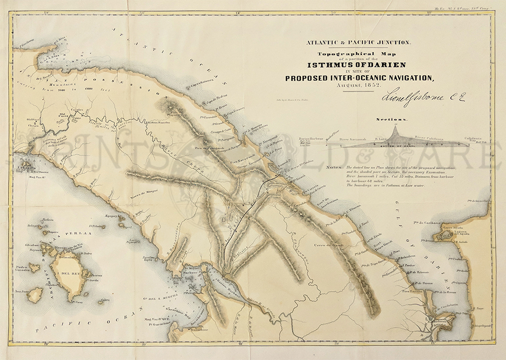
125rare:
1852 PANAMA. Lionel Gisborne Topographical Map of a Portion of
the Isthmus of Darien. This important map shows the proposed canal
prior to the Panama Canal, connecting the Atlantic to the Pacific. It
also has a profile detailed. Excellent condition with expert hand
colored steel plate engraving.
19.25 x 14.25" plus margins.
$250
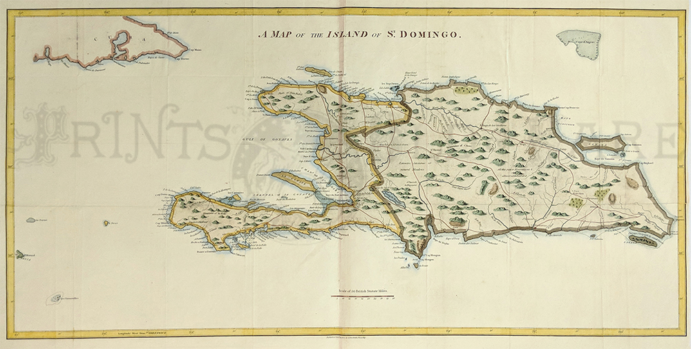
128rare:
c.1800
CARIBBEAN. J.
Stockdale. English map of the island of Santa Domingo showing modern
Haiti and Dominican Republic, and the eastern portion of Cuba.
Beautiful steel plate engraving
with expert water coloring.
36" x 18" plus margins.
$400
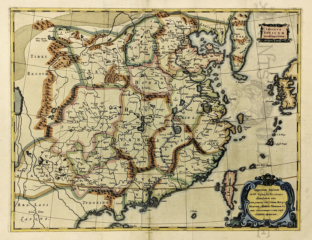
131rare:
1670 China amd Korea. A. Kircher. Imperium Sinicum Quindecupartitum.
Beautiful map compiled by the Jesuit Father Martino
Martini. The trading route between Canton and Peking is noted and the
great wall and the Gobi Desert are pictured. Water colored copperplate
engraving on handmade paper
in excellent condition.
15 x 12" plus margins.
$2,500
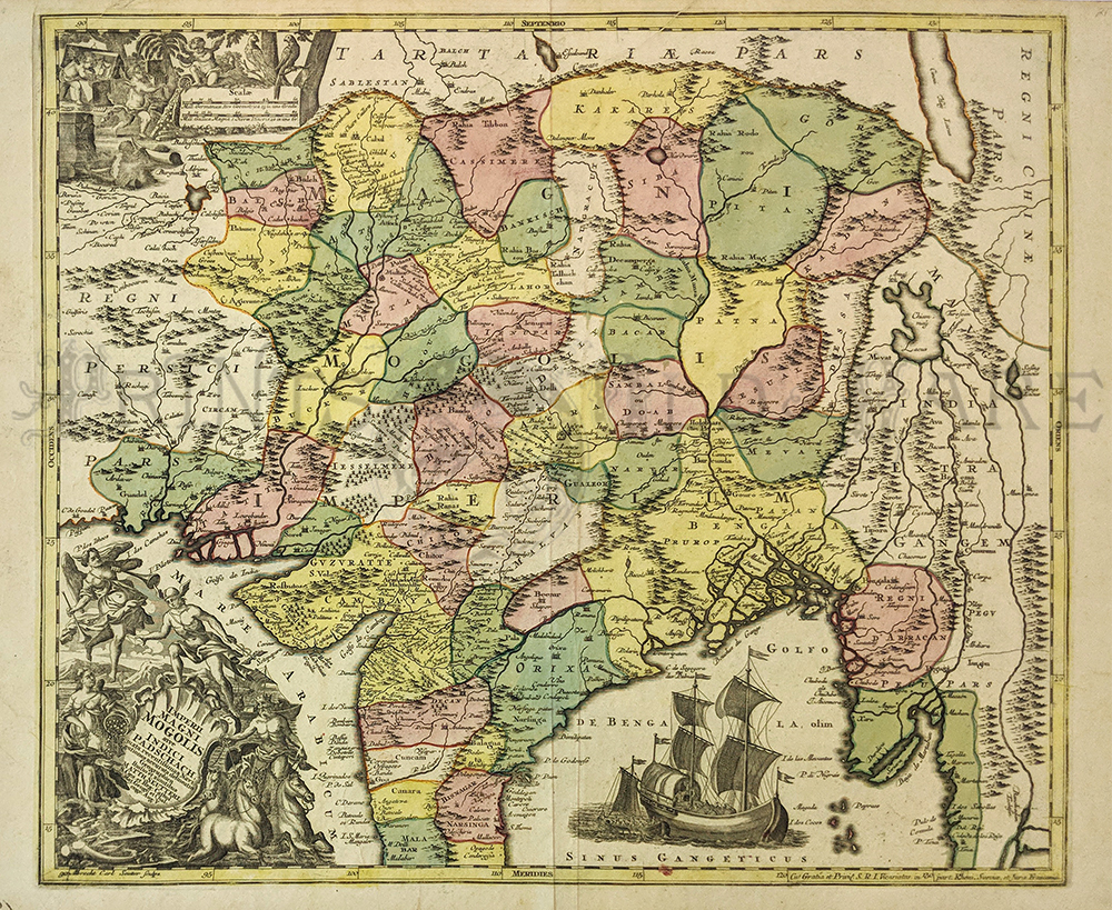
132rare:
1750 INDIA. Albrecht Carl Suetter. Imperii Magni Mongolis . from
Afghanistan through the Himalayas to Myanmar and most of India. Each
province is individually water colored. Beautiful cartouche and
vignette of sailing ship. Watercolor to copperplate engraving on
handmade rag in outstanding condition,with bright colors.
22.5 x 19.5" plus margins.
$1,600

133rare:
1796 Cochin, China Chart. Including Touron Harbour and the Island of
Callon, . H. W. Parish & J. Barrow. showing the coast of
Vietnam and today's Danang with inset showing the land profile. Steel
plate hand colored engraving from Staunton's survey June 1793. Left
border has been patched 3" at bottom. Excellent condition.
17 x 22" plus margins.
$375
134rare:
c.1768 East Indies. Map of the East Indies from the latest
Authorities by John Blair. Highly detailed topographical map with inset of
the Philippine Islands. Excellent condition with minor repair
on original fold.
22 x 16.25" plus margins.
$600
136rare:
c.1780 North Vietnam. Engraved by Canu, Map of Tunquin, Where the
Vietnam War started. Shows the many rivers around the capital Hanoi, in
North Vietnam, compiled by several reports of early French Jesuit
explorers. Watercolor copperplate engraving on handmade paper. Very
good condition.
Measuring 14 x 14" plus margins.
$450
137rare:
1790 Southeast Asia, La
Presqu'Isle de l'Inde shows the Archipelago of the East Indies
including Vietnam, Malaysia, Cambodia and Java published by Bonne. Water
colored copperplate engraving on hand made paper. Measuring:
10 x14" plus margins.
$350
139rare:
1746 North America. Hand colored copper engraved Map showing Amerique
Septentrionale (French Map of North America) by Jean Baptiste
Bourguignon d'Anville. Paris. Four professionally joined sheets.
41 x 36 in.
$1,500
142rare:
Eastern Hemisphere 1720. “Orbis Terrarum verteribus cogniti Typus ad
mentem veterum Geographorum praesentatur a Christ. Weigelio.” Hand
colored, copper engraving. Shows a detailed map of the Eastern
Hemisphere, shows what is known as Australia.
15 x 12 image size $350
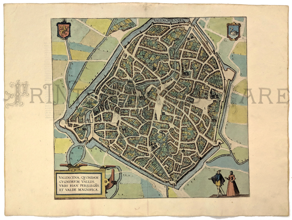
238fra:
Valencena Quondam Cygnorum Vallis. Original Braun & Hogenberg
map of Valenciennes. Beautifully hand colored copper engraving.
13 7/8 x 15 1/8 in. $395
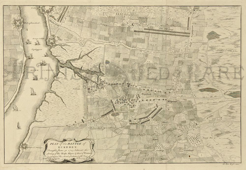
000low:
1750 Netherlands. Plan of the Battle of Eckeren, Netherlands,
Rapin-Thoyras - An engraved and highly-detailed, regional black and
white map, showing Fort St. Philip.
Condition: Very good, two vertical folds, some water staining
on lower left margin.
size, 18.5 x 14 image.
$120
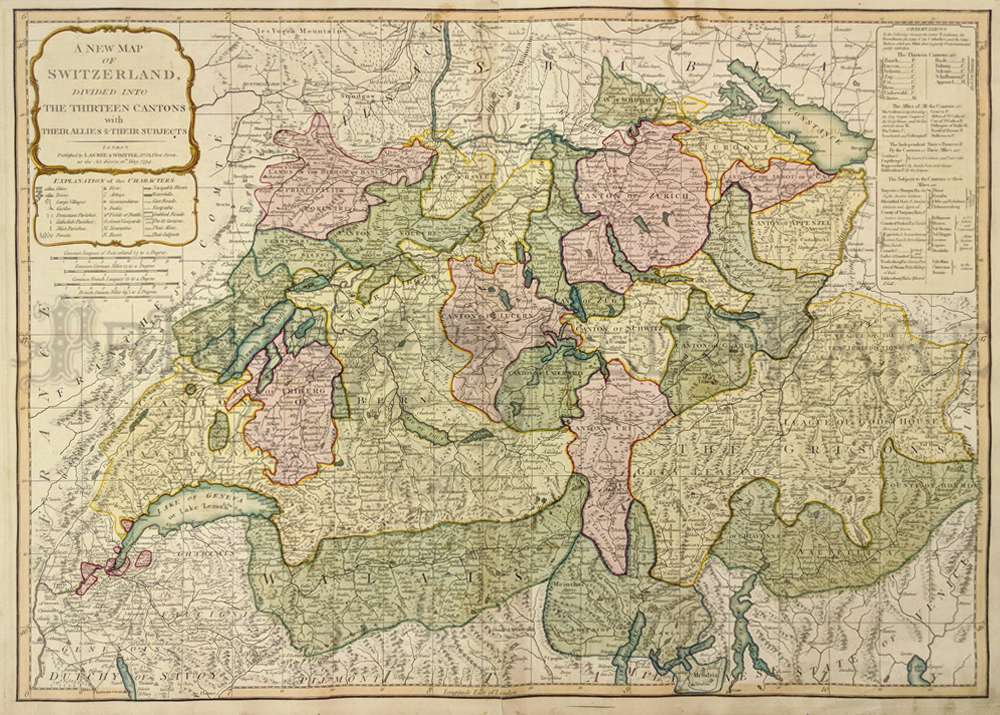
000swi:
1794 Switzerland. Divided Into the Thirteen Cantons with their Allies
and their Subjects. Hand colored copper engraving showing great detail
of towns, castles, parishes, navigable rivers, Fields of Battle, great
vineyards, mountains, cities, and many more historic places.
28 x 20-1/2 in. $375
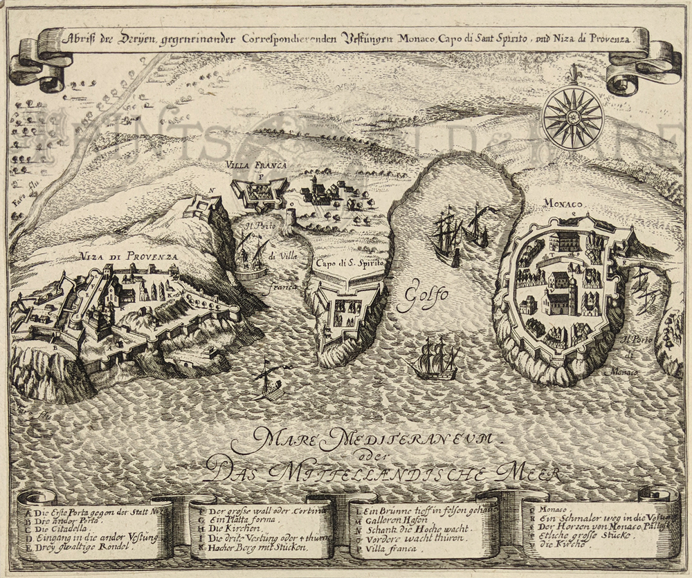
003fra:
c.1704 Monaco (Nice Provence) Abriss uncolored copper engraving of the
Mediterranean Coast by Gabriel Bodenehr in Augsburg. Map's title is,
"Abriss der Dryen gegeneinander Correspondierenden Vestungun Monaco,
Capo di Sant Spirito und Niza di Provenza."
7-1/2 x 6 in. $250
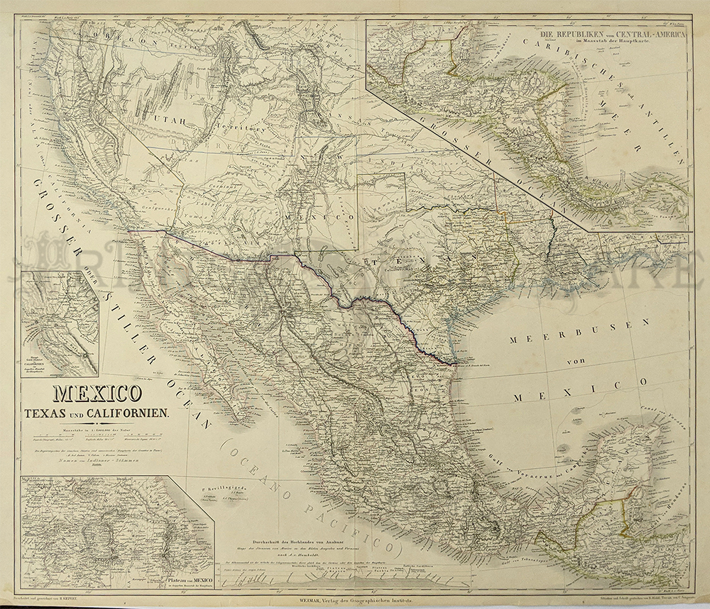
100tx:
1852 Mexico, Texas and California Map by Kiepert. Fine large format map which also includes Deseret
(Utah Territory) and New Mexico Territory. Insets of the Gold Region,
Central America and Mexico City. Hand colored steel engraved.
Condition: Very good.
27-1/2 x 22 in. $2,500
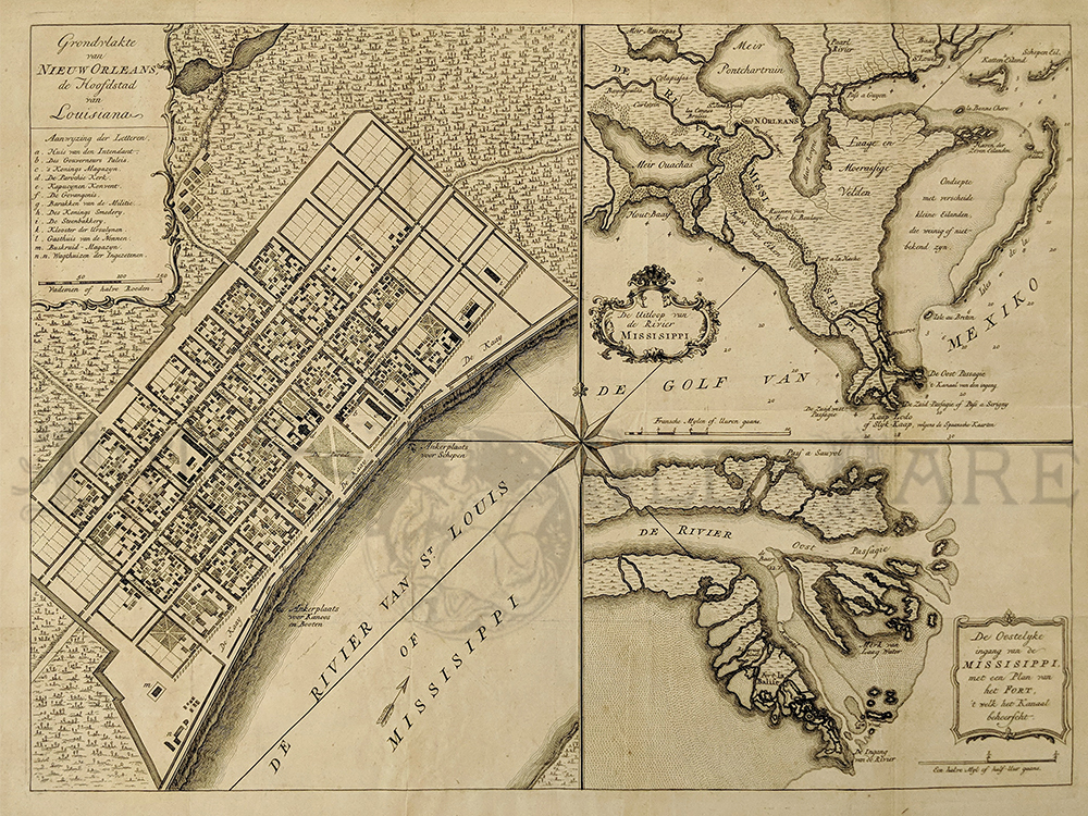
257no:
Grondvlakte van Nieuw Orleans de Hoofdstad van Louisiana. 1769 Copper
engraved Plan of New Orleans which shows ancient views of New Orleans
and the Mississippi River Delta. The city layout is displayed in the
larger of the maps and the smaller maps detail the mouth of the
Mississippi and the east passage detailing Fort La Balise. Engraved map
is by Isaak Tirion.
19 x 15 in. $1,800
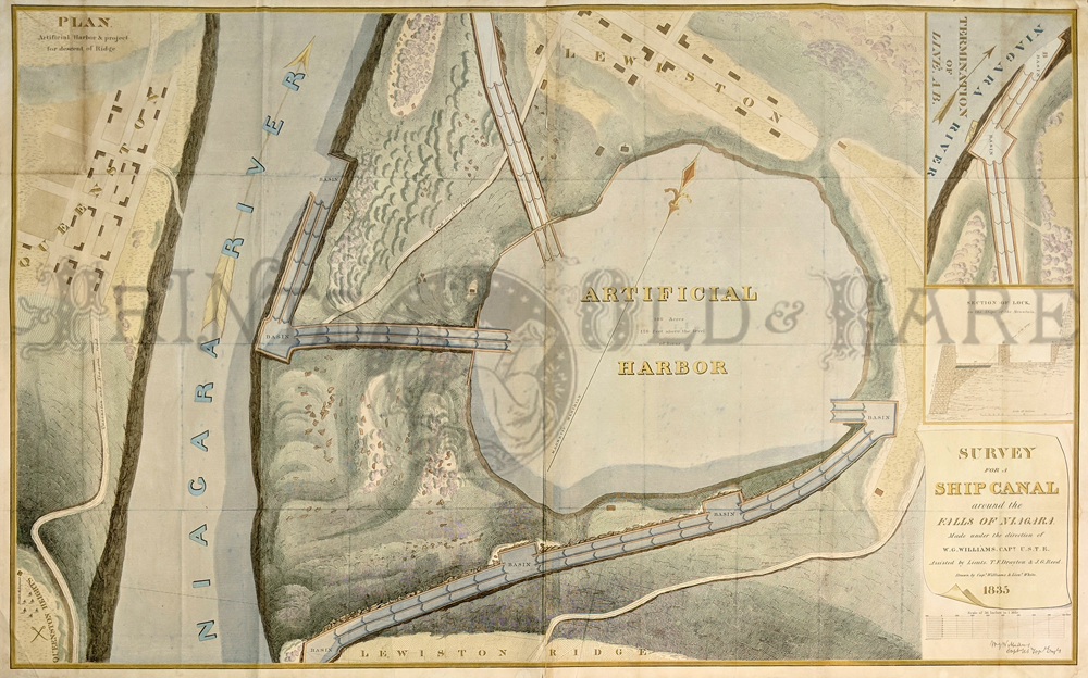
300NewYork:
Survey for a Ship Canal around the Falls of Niagara. 1835. This map
depicts an artificial harbor as part of a proposal route to Lake Erie
to Lake Ontario by W. G. Williams. Insets: Termination section of
locks and plan for artificial harbor.
48 1/4 x 31 in. $495
|
|