002tx:
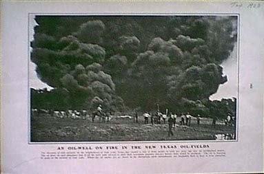
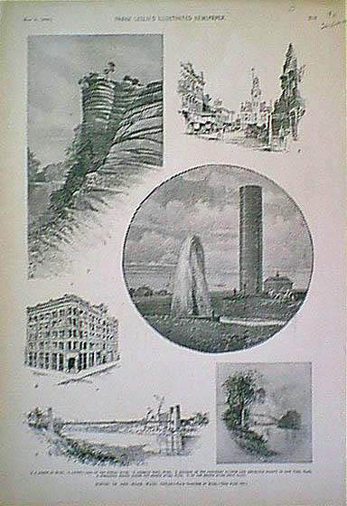
1903 Texas Oil Well Fire. Early photo of oil field fire at Sour Lake,
Texas. 13x9 in. $30
004tx:
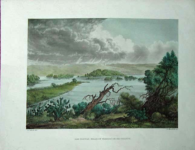
1858
view, Presidio De Rio Grande. "Las Isletas- Falls of Presidio De Rio
Grande." A beautifully watercolored old steel engraving from the U.S./
Mexico Border Survey, 1858. Shows the shoreline of the great river with
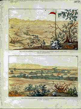
indigenous cactus and other plants and island out in the river. Storm
clouds loom in the distance. Genuine antique print, 142 years
old.
10.75x 8.5 in. $60
005tx:
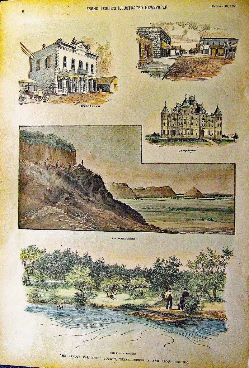
1890 Val Verde County, Texas - Hand
colored wood engraving featured in Frank Leslie's Illustrated Newspaper
showing the Court House and Opera House, the Ochre Mines, San Felipe
Springs. Showing Scenes in and about Del Rio. Fine condition.
16 x 10-1/2 in. $80
007tx:
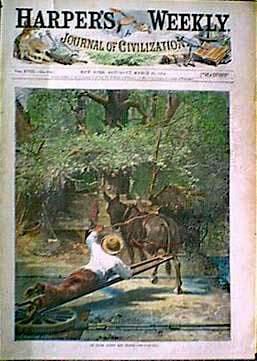
1874 Irrigation in Texas. Hand colored front page engraving from
Harper's. 11x16 in. $60
008tx:
TEXAS/MEXICAN
BORDER VIEWS - 1857. Two fine engravings, professionally watercolored,
generated by the U.S. & Mexican Boundary Survey, 1857. Views
from
Iron Monument No. 11. Top view near the edge of the Colorado Desert
looking east towards Monument No. 4. Lower view looking southwest
towards the Cordilleras of Lower California - an authentic
antique.
8-1/2" x 11-1/2" $40
010tx:
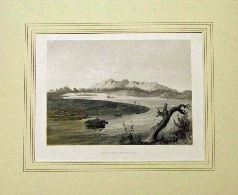
1857 ANTIQUE RIO GRANDE VIEW - FRONTERA.
Fine old steel engraving, "Rio Grand - Near Frontera." Shows a bend in
the river at dusk, with deer coming out to drink at water's edge. Rocky
bluffs in the distance across the river. Antique print produced in 1857
from the U.S. & Mexican Boundary Survey.Matted.
14 x 12 in. $50
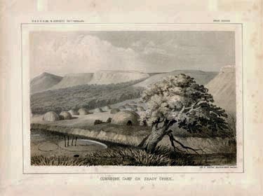
011tx:
1858 Antique Texas view. "Comanche Camp on Shady
Creek." Litho from Railroad Survey. 11-1/2x8-1/2 in. $50
012tx:
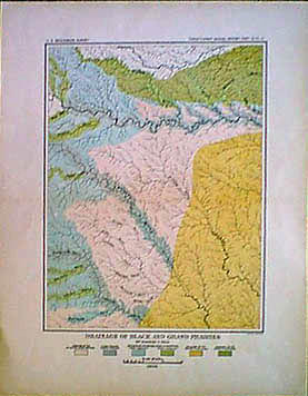
1900
Texas Geological map. Color litho shows drainage of Black
and Grand
Prairies.
By US Geological Survey. 11-1/2x14-1/2 in. $30
015tx:
GAINESVILLE
TEXAS - ANTIQUE VIEWS. Eleven engraved views, professionally
watercolored, from the German edition of Frank Leslie's, Sept. 1890.
Captions in German describe several scenes in this city near the Red
River in northern Texas. The reverse side has article in German on "Der
'Lone Star' Staat." A genuine antique print.
11" x 16" $50
016tx:
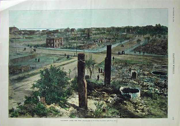
Galveston
After the Fire. This hand colored birds eye view shows the rubble of
buildings destroyed by the fire. This genuine antique print is from the
November, 1885
edition of Harper's Weekly.
11x16 in. $80
018tx:
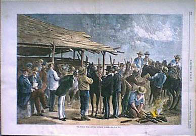
1876 Texas view. "The Indian War - Buying Cavalry Horses." Hand colored
engraving from Harper's. 16x11 in. $60
019tx:
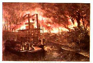
1878
RED RIVER VIEW - FOREST FIRE. "Forest Fire on the Banks of the Red
River," drawn by W.A. Rogers, 1878. A professionally watercolored
engraving showing a barge and riverboat anchored on the river while
passengers watch the raging fire. Authentic
antique print - 122 years
old.
11" x 16" $50
020tx:
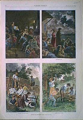
1874 Texas views. Four nicely hand colored engravings on one page
depicting "Scenes in Emigrant Life." Harper's. 11x16 in. $50
023tx:
1874
Texas Stagecoaches. "Staging in the Far West." Four hand colored
engravings on one page depicting stagecoach activities. Harper's.
11x16
in. $60
025tx:
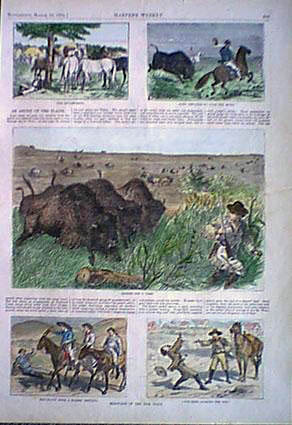
1874
Western Views. Interactions with buffalo and other hand colored
engraved scenes of the American West, with text from Harper's.
11x16
in. $50
027tx:
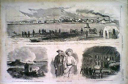
1866
Wood engraving showing Matamoras Mexico Battle. U.S. troops attack
Government House. Four original engravings on one page depicting this
1866 battle. Harper's. 15-1/2x10-1/2 in. $30
Hand colored: $40
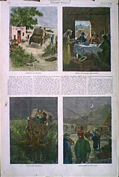
028tx:
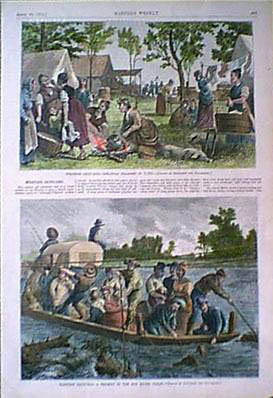
1874
Red River view. Early immigrants make their way in an overcrowded boat
down the swollen Texas river. Hand colored wood engraving. 10-1/2x8-1/2
in. $50
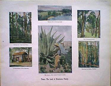
031tx:
1907
Texas Views. Titled "Texas: The Land of Bounteous Plenty." Hand colored
views: Among the Long Leaf Pines, Hunting for Edible Turtles, In a
Cocoanut Grove,
The Agave, and others.
14-1/2x11 in. $40
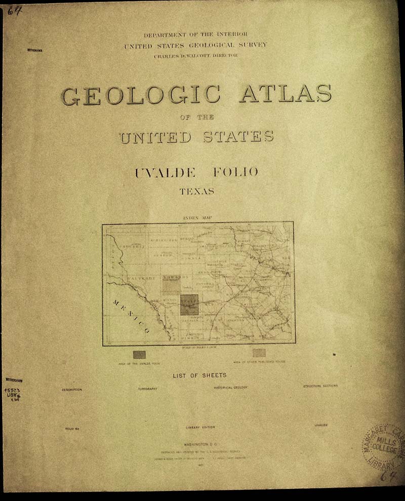
035tx:
1900
Texas Atlas. Uvalde quadrangle folio, published by U.S. Geological
Survey. Uvalde
County, West of San Antonio. 12
pages including three large color Topographic Historical
Geology Structural Section maps and much text. Each map measures:
18-1/2x21-1/2 in. $70
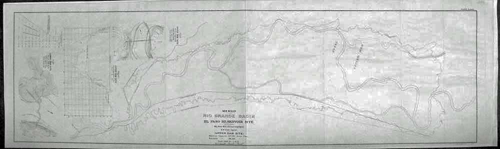
041tx:
1893
MAP - EL PASO RESERVOIR PLAN. This old map shows the Site of the El
Paso Reservoir in the Rio Grande Basin, with sketches of plans of the
Upper and Lower Dams, and a profile of the Upper Dam site. U.S. Corps.
of Engineers. 107 years old!
37" x 11-1/2" $45
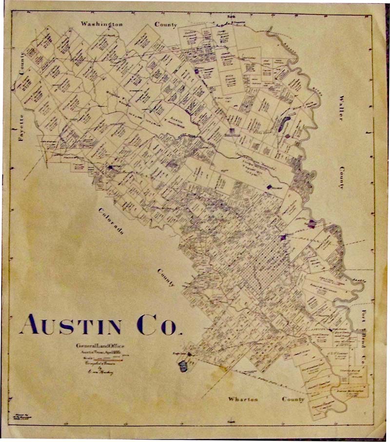
042tx:
Austin County Map - Based on General
Land Office 1895 issued by Bramletts in 1915. Shows land usage,
property owners, waterways. A lightly-tinted lithograph.
16 x 13-1/2 in. $150
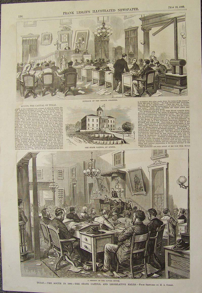
043tx:
Austin, Texas - Legilslature 1880 -
Rare early view of Texas State government, small view of State Capitol.
The accompanying article calls Austin "whitest and brightest of cities,
referencing to the marble buildings. Wood engraving featured in Frank
Leslie's Illustrated Newspaper.
16 x 11 in. $90
SOLD
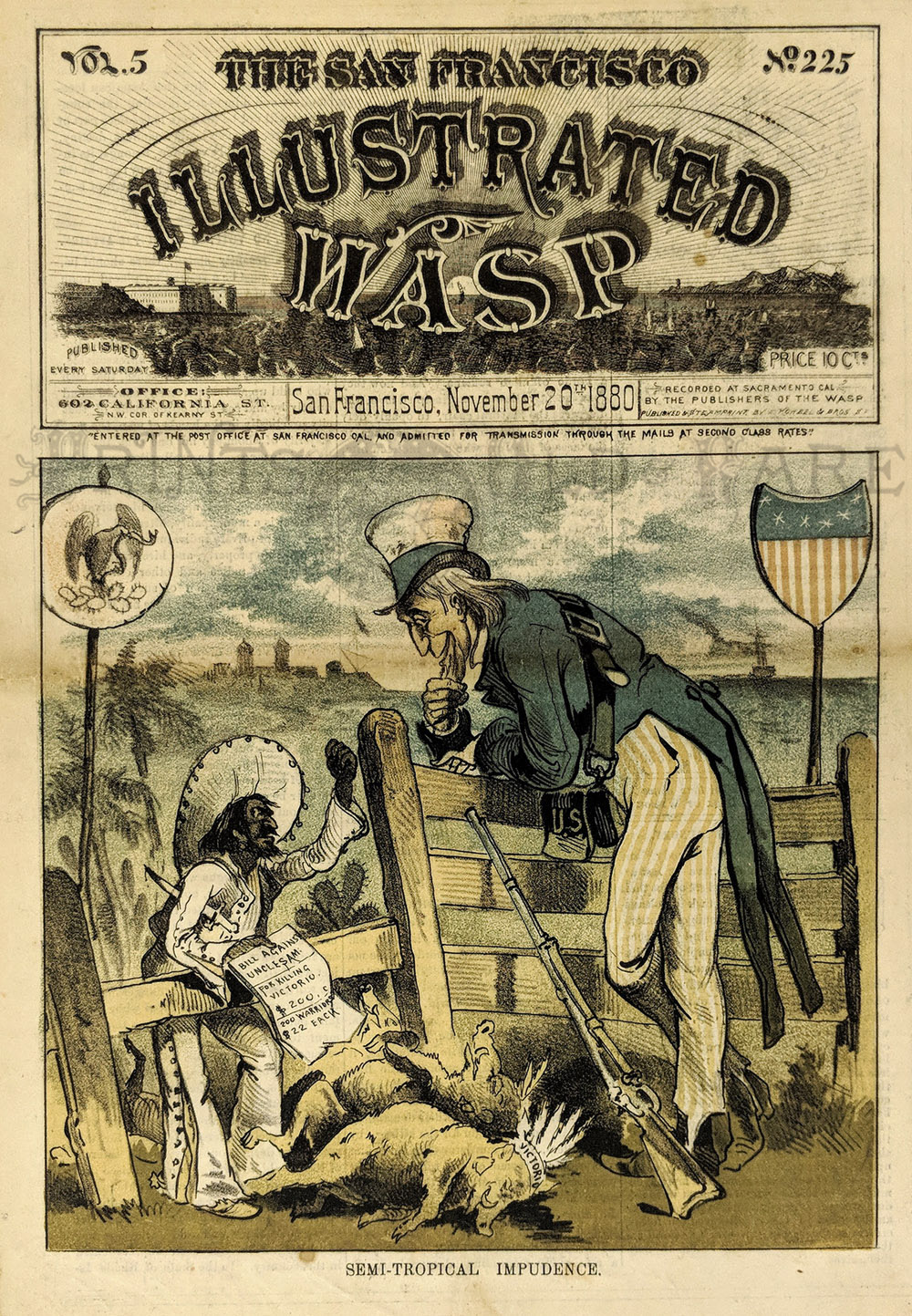
004SanFrancisco:
Mexican War Cartoon.
Apache Warrior
Victorio, died near border. 1880 San Francisco
Illustrated Wasp "Semi-Tropical Impudence." An amused Uncle Sam leans
over border fence as the Mexican Government asks for money to help
defeat Victorio. Victorio pictured as a dead wild boar.
Chromolithograph Wasp Cover.
14 x 10 1/4 $150
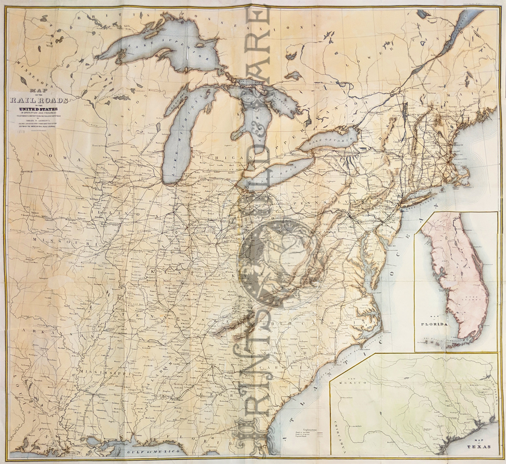
226rr:
Map of the Railroads in the United States in operation and progress.
1853 Ackerman Lith. Company NY. Showing the railroad names, routes,
roads in operation, projected, and in progress of the eastern part of
the United States. Inset showing maps of Florida and Texas. *All folds have been
reinforced.
40 x 42 in. $400
|
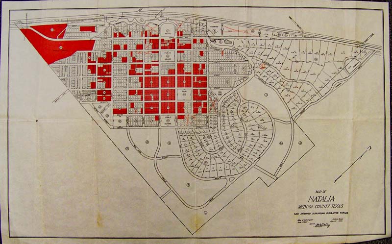
098tx:
Map of Natalia, San Antonio Suburb - 1928
Medina County, Texas "Ittigated Farms" which shows schools, hotels,
streets, and lots. Published by the Office of Chief Engineer
and
printed in color.
27 x 17 in. $125
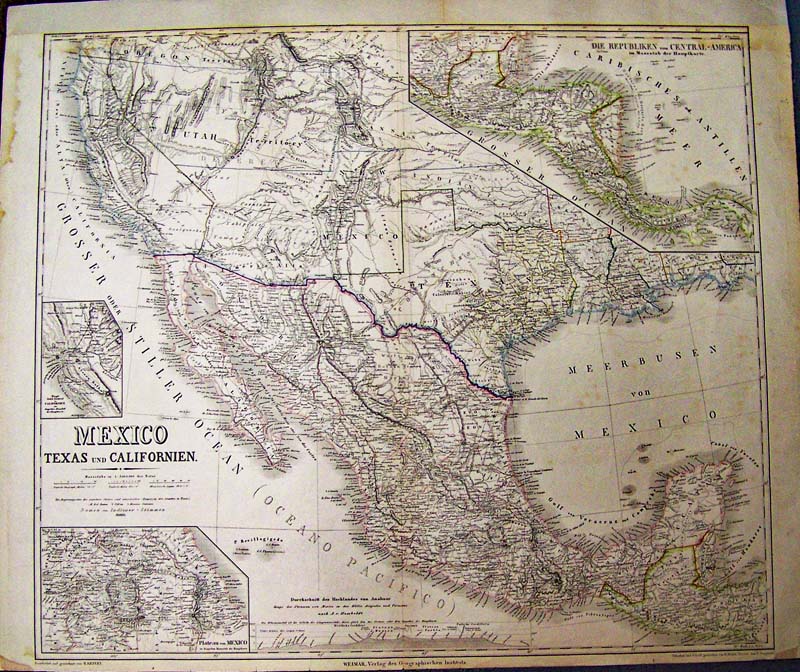
100tx:
1852 Kiepert Map of Mexico, Texas und Californien.
Fine large format map which also includes Deseret (Utah Territory) and
New Mexico Territory. Insets of the Gold Region, Central America and
Mexico City. Hand colored steel engraved map.
Condition: Very good.
27-1/2 x 22 in. $2,500
Check for
Availability
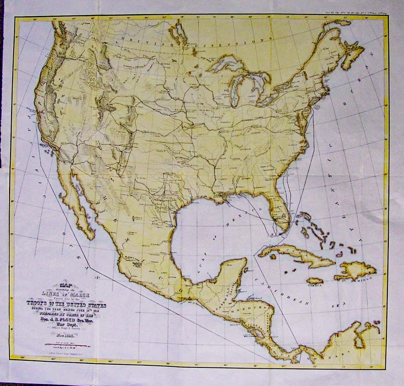
000army:
U.S. Mexican War Forts, 1858 - Hand
colored lithographed map by Siebert and Kogge, Washington, D.C. depicts
"Lines of March" passed over by the Troops of the United States and the
Mexican War, showing the United States, Central America and the West
Indies. Details a line from New York to Havana to Panama then to San
Francisco. Lines include the National Road, marches up the Mississippi
River to St. Louis; and much travel, showing the forts, camps and
barracks in Texas; Forts include a march from Fort Yuma to Pimas,
Tucson and Fort Buchanan near the border.
Condition: Very good with slight folding creases. This map is
unusual and rare.
19 x 17-1/2 in. $350
103tx:
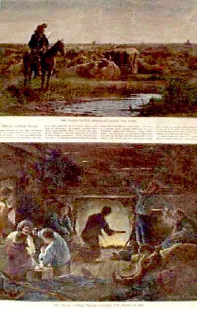
1874
Texas Cattle Trade. Color wood engravings show two scenes of the cattle
trade--guarding the herd and the night guard. Published in an 1874
issue of Harper's Weekly.
11x16 in. $60
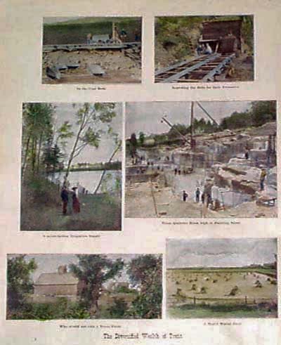
111tx:
1907
Views of Texas Natural Wealth. Six hand tinted photographic views on
one page, titled "The Diversified Wealth of Texas." Published in 1907
as an illustration to a book. Shows views of Texas mines,
rivers,
quarries and farms.
11x16 in. $50
114tx:
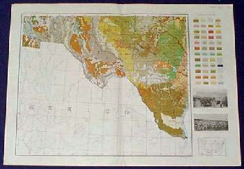
1931
Soil Map: Central and West Texas. Interesting, color coded map of
central and western Texas, published in the 1931 Atlas of American
Agriculture. Colors indicate different soils throughout the region.
Also included are small inset photos of desert vegetation and a cotton
field.
19x26 in. $50
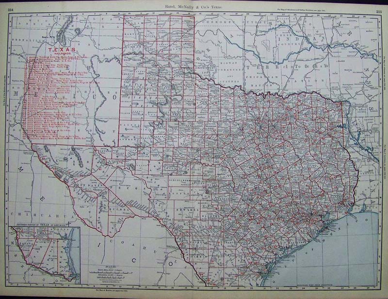
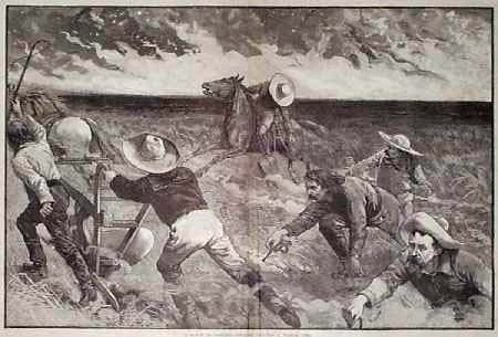
115Texas:
1898 Rand, McNalley & Co.
Color Texas Railroads Map which also has inset of the Southern Portion
of Texas on bottom left. Key to all the railroads is on top left. Each
county in Texas is outlined in red.
27-1/2 x 20-1/2 in. $300
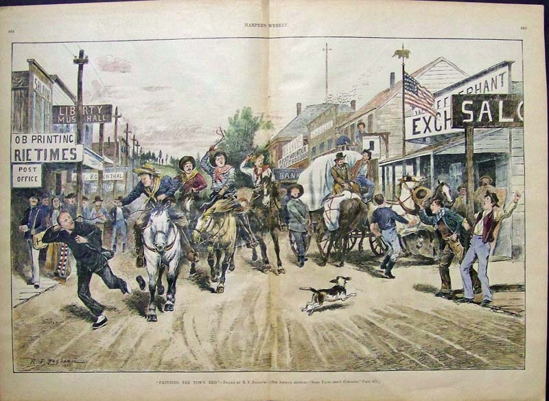
118tx:
1886 Cowboys : Painting the Town Red by Zogbaumn. Hand
colored, wood-engraving.
16 x 22 in. $250
119tx:
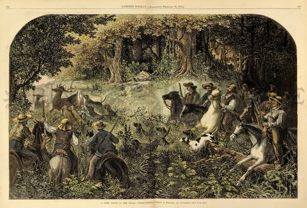
1874:
Hunting Deer in Texas. Nicely hand colored engraving from Harper's
Weekly, titled "A Deer Drive in the Texas Cross-Timber." Men on horses
are shown riding through the woods, with their hunting dogs running
after
two deer ahead of them.
16x22 in. $300
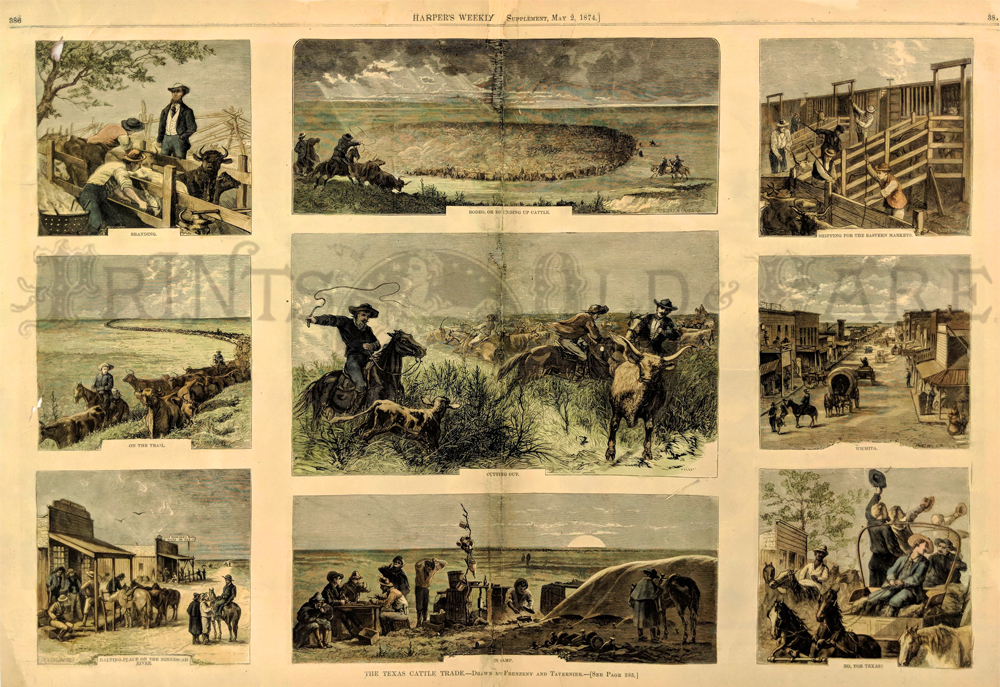
201tx:
1874 RARE
Antique Texas Cattle, Cowboy Scenes. Hand colored, engraved scenes from
Harper's Weekly. Title is "The Texas Cattle
Trade." Cowboys are shown rounding up cattle, branding them, moving
them across the prairie and shipping them to Eastern markets. Wonderful
views of life on the range, from the golden age of
the
Texas cowboys!
22 x 16 in. $350
203tx:
1886
Cowboys Fight Prairie Fire. Dramatic woodcut engraving from the July
17, 1886 issue of Harper's Weekly, titled "A Ranch in Danger: Cowboys
Fighting a Prairie Fire." Shows a group of cowboys racing for their
lives as the fire approaches. Excellent condition.
16x22 in. $200
301tx:
1874
Texas-The City of Dallas, Its Progress and its Prospects. This
beautiful hand colored engraving is from the 1888 Frank Leslie's
Illustrated Newspaper. It shows views of City Hall from 3 different
sides, the Alliance Exchange Building, 4 private residencies, the
corner of Commerce and Elm streets, Merchants' Exchange, Texas State
Fair Grounds, and the Dallas Club House. 22.5x16 in. $150
311tx:
1890
Waco & Vicinity. 1890. Shows scenes of : a
street in Waco, Lover's Leap on the Boskey River, an Artesian well,
Building of the Provident Savings Life Assurance Society of New
York. Wood engraving.
11x16 in. $50
322tx:
1890
Views of Waco, Texas. This hand colored engraving shows the Rotan Mann
building, the Federal Building, Sanger Brothers the residence of S.B.
Parrot and Baylor University. This rare print is from Frank Leslie's
German publication. 11x16 in. $80
327tx:
1890 El Paso and Houston. This hand colored
engraving
shows 4 views of El Paso and 3 of Houston: El Paso city, a school
house, a railroad station, the Court House, a Hotel, a Synagogue, and
Buffalo Bayou. This rare print is from Frank Leslie's
German
publication.
11x16 in. $90
331tx:
1888
Views of Austin, Texas. This hand colored engraving shows views of the
Driskill Hotel, the Stuart Seminar, Ph. Hatzfald and Co., Texas State
University, St. Mary's Academy, Huftin White Lime Co.and St. Edwards
College. This rare print is from Frank Leslie's German publication.
11x16 in. $60
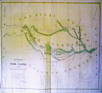
335tx:
1849 Boundary of the Creek Country Surveyed under the direction of the
Cureau of Topographical Engineers. This rare, large map is also known
as the Abert Survey and runs from Fort Smith, Arkansas to the Texas
border through Cherokee, Choctaw and Creek Indian country. It shows the
roots of the Canadian and Arkansas River. This map is in excellent
condition. There is a small chip in top left corner that does not
affect image.
38x26 in. $900

337tx:
1937
Greater Texas and Pan America Exposition, Dallas June 12 to October 31.
2 sided pamphlet. Shows expo from the air, and the midway
State of
Texas building.
9x24 in. $30
348tx:
Three
hand colored wood engravings from the July 28, 1888 issue of Frank
Leslie's Illustrated Newspaper. Page is titled, Texas - Views in Paris,
One of the Representative Cities of the Lone Star State. Two small
images above are of, The Court House and A School Building. Larger
picture on bottom is captioned, Market Day - Scene on the Market
Square.
11x16 in. $60

349tx:
Large Texas Map, 1888 - Original color lithographed map with 3 insets
-- corner with El Paso and the Panhandle. Published by Rand McNally.
Very good condition.
29 x 25 1/2 in. $325
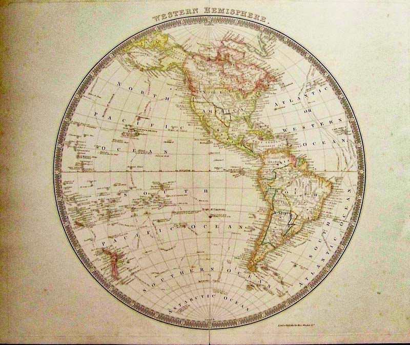
203wld:
Western Hemisphere with The Republic
of Texas, Tesdale, 1842 - A nicely engraved British hemispheric map
with original color shows the continents with a surprising amount of
detail including rivers, place names, Indian Tribes, and coastal
detail; locates Buenos Ayres, Mexico City, Santa Fe, Santa Barbara,
etc. Rarely seen in maps, the Independent Republic of Texas is depicted
and in North America, the United States is depicted with its western
boundary along the Rocky Mountains and in the Northwest. The border
with Canada is left open-ended with British coastal claims extending to
the Columbia River, relating England's position on the Fifty-Four Forty
dispute. The map extends to show the South Pacific Islands and New
Zealand. All of the important voyage routes of Capt. Cook and Clerke
are shown. Surrounded by a keyboard-style circular border.
Condition: Very Good, large globe with some foxing on edges
and
fold down middle.
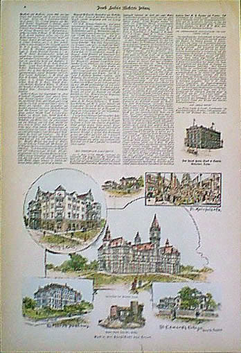
size 14.5 x 14.5 image
$295
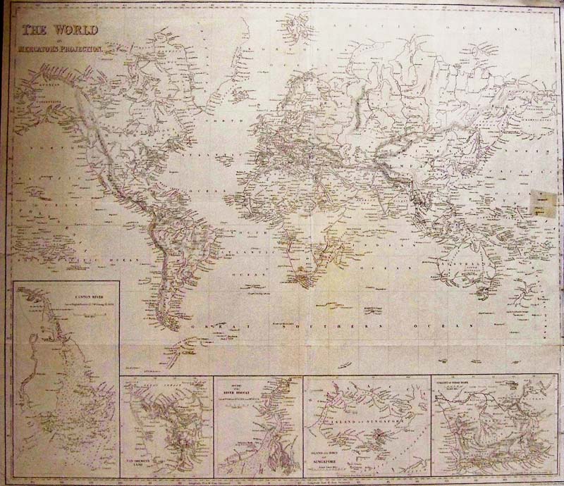
204wld:
The World on Mercator’s Projection, and Texas as a Republic, Harper
Brothers, 1847 - A large black and white engraved map of the world with
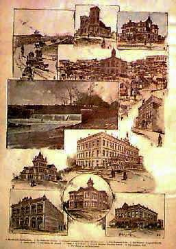
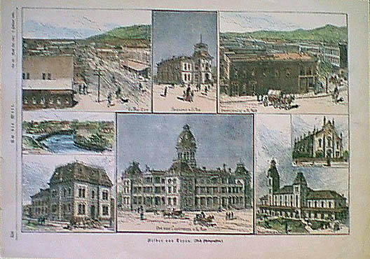
five detailed insets of Australia, India, Singapore and South Africa.
The map also shows Alaska as Russian Possesions, Northern Canada as
British Possessions and Texas as a Republic. Insets are: Canton River
(Macau & Hong Kong); Van Diemen's Land (Tasmania); River Hoogly
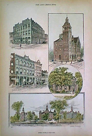
(Calcutta); Island and town of Singapore; Colony of Good Hope. Engraved
by Charles Copley New York. Condition: Good very small margins, a small
repair to right margin barely into image, multiple folds throughout.
Size 21.5 x 18.5 image $295
|
392tx:
Texas as a
Republic. Bradford 1835. Color outline shows Comanche
Indians, West Texas has "Droves of Wild Cattle and Horses," and Land
Grants.
9 3/4 x 11 3/8
in. $1000
Check
for
Availability
394tx:
Panoramic view of Camp MacArthur, Waco, Texas, April 9th, 1918.
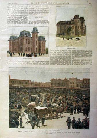
Photograph by Fred A. Gildersleeve. Fold in the middle.
5 x 38 1/8 in. $60
397tx:
Texas as a Republic “Amerique Septentrionale” by N. Lorrain (c.1840) –
Mexico extends North to Oregon Territory – East to Mississippi River.
Matted.
10 ½ x 14 ½ in. $400
399tx:
1860 Johnson's New Map of the State of Texas. Cities, towns, railroads,
stations, roads, creeks, rivers, and other topographical
details are also shown. Some Military Outposts and Indian information
is also highlighted.
Insets detail Sabine Lake (with depth
soundings), Galveston Bay (from the U.S.C.S.), and Plan of the Northern
Part of Texas.
Hand colored, lithograph.
18 x 25 in. $350
400tx:
c.1886 Map of Texas. Published by the People's Publishing Co. Chicago,
IL. Outline colored by counties. Inset showing Northern Texas.
13 1/2 x 21 5/8 in. $80
401tx:
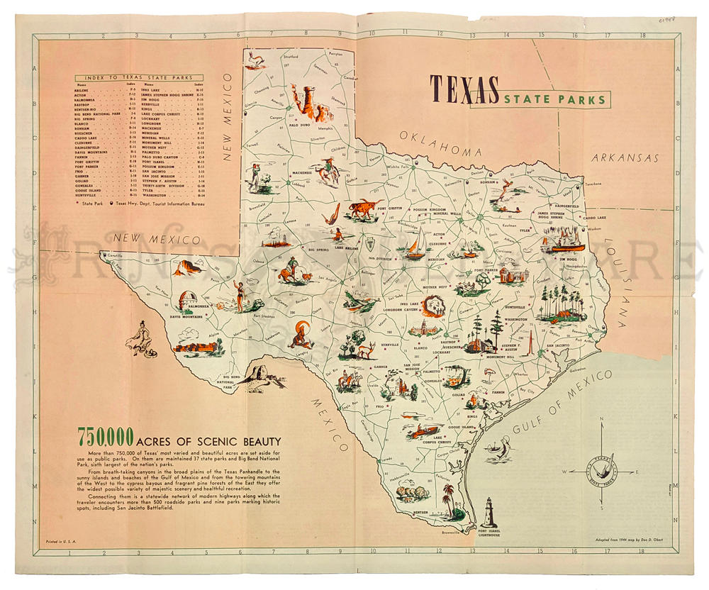
Texas State Parks 1948. Pictorial Map by Don Obert for the Texas State
Park Board. Info & pictures on verso. Originally folded. Very
good
condition.
16 1/2 x 20 1/8 in. $80
402tx:
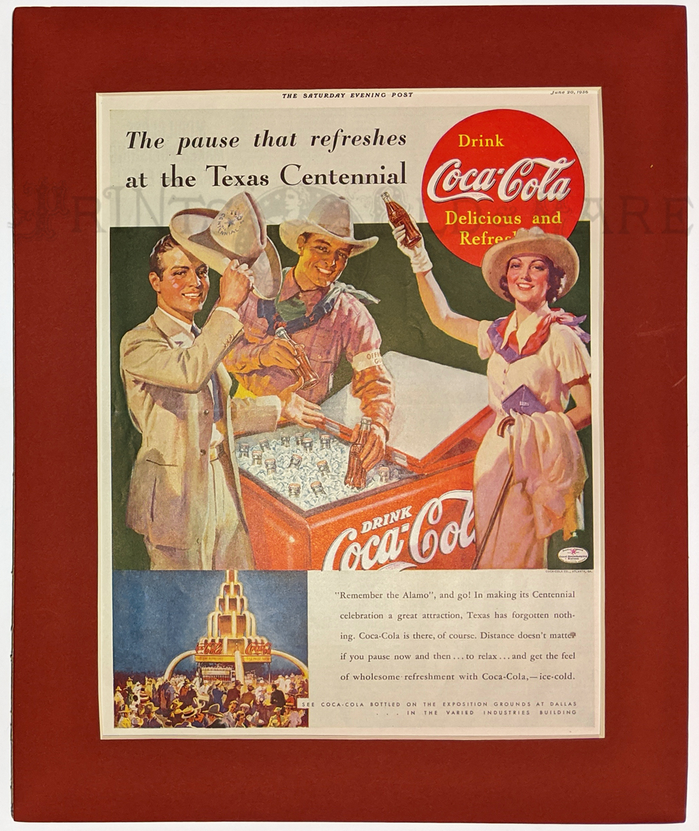
Texas Centennial Celebration 1936 in Dallas. Coca Cola ad "The pause
that refreshes at the Texas Centennial." Saturday Evening Post June 20,
1936. Original ad in red mat. "Texas has forgotten nothing."
Image Size: 11 x 14 in.
Mat size: 13 1/8 x 16 1/8 in. $25
403tx:
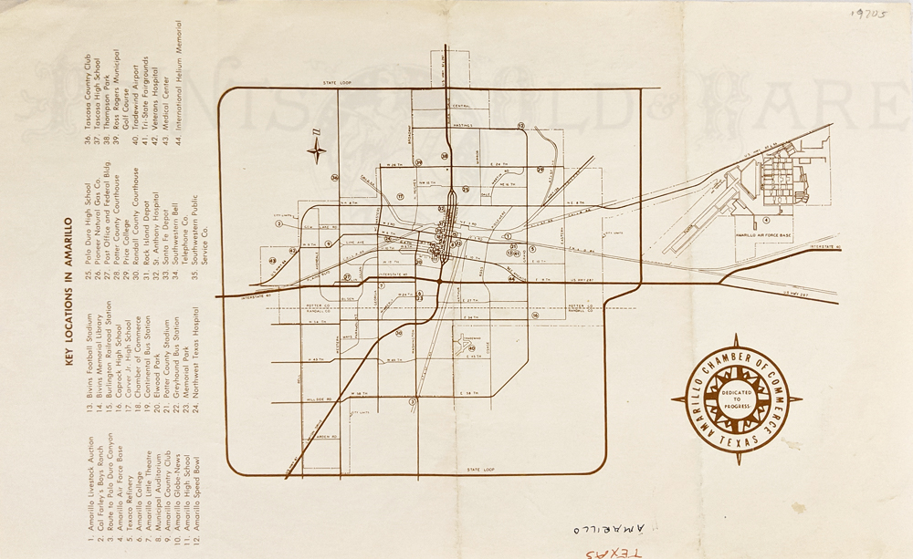
Amarillo Map c.1870s. Chamber of Commerce. 44 Key locations identified.
8 ½ x 13 7/8 in. $30
404tx:
Rio Grande near Frontera (near El Paso) 1858. Hand colored lithograph
view from the important U.S. Mexican Boundary Survey.
Size: 11 ¼ x 8 ½ in. $75
405tx:
Dallas City Map c.1895. Grid pattern. Shows streets, railroads, parks.
Archivally mended tear in left margin leading 1" into map.
11 7/8 x 15 1/2 in. $40
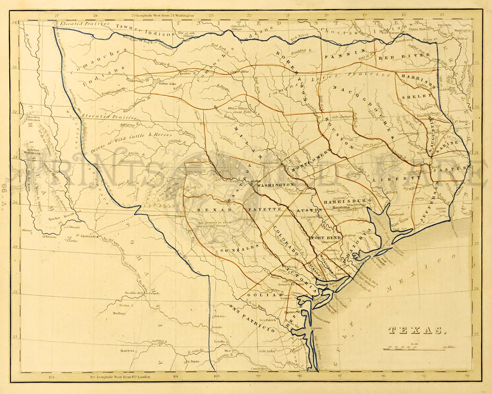
407tx:
Lopena Island / Padre Island. 1946 – Satillo Ranch. Orignally published
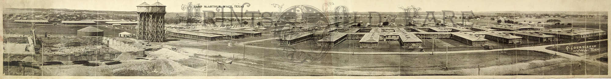
in 1923, updated to 1946. Close up of coast by Laguna Madre. Interior
Department – Geology Survey. **Top middle fold has been reinforced.
20 ¾ x 32 ¼ in. $40
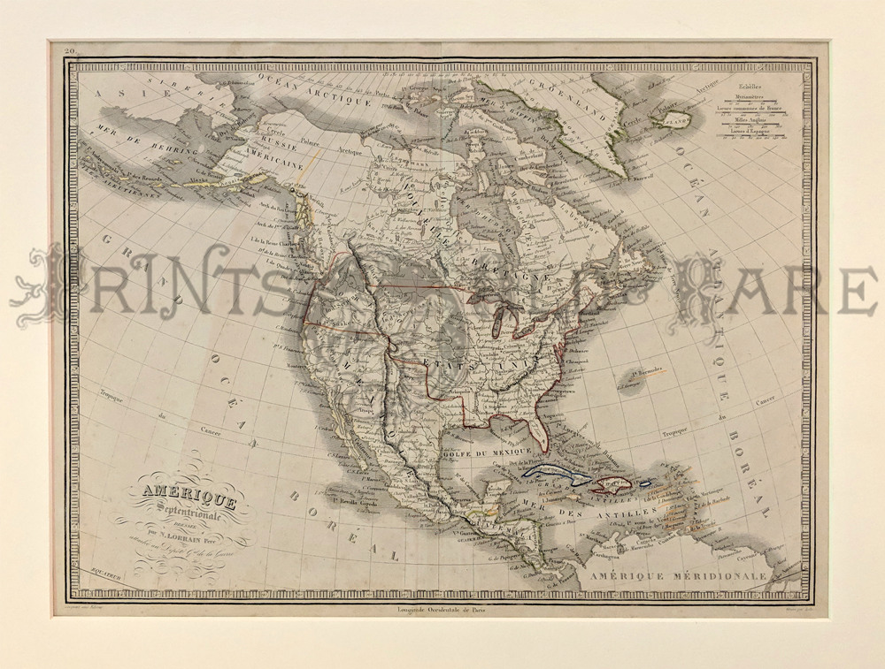
408tx:
Sabine Pass 1853. Louisiana-Texas border. Hand colored, lithograph map
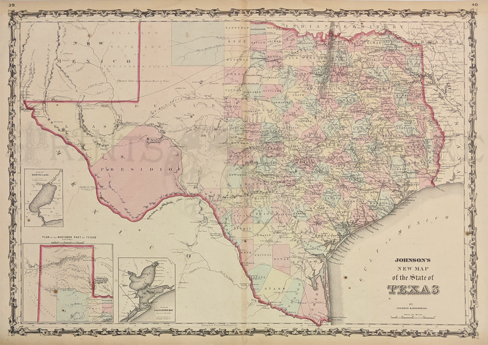
by U.S. Coast Survey. Very good condition.
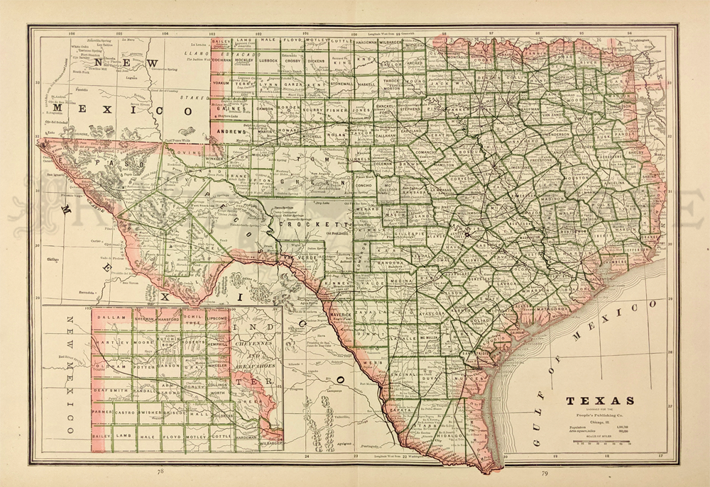
10 3/8 x 12 5/8 in. $60
409tx:
1860 Mitchell's County Map of Texas. Showing county and territories.
Some topographic features included such as the Staked Plain with
vegetation and water availability noted. Inset of Galveston Bay
& vicinity. Hand colored lithograph. **Center fold has been
reinforced.
12 1/4 x 15 1/2 in. $300
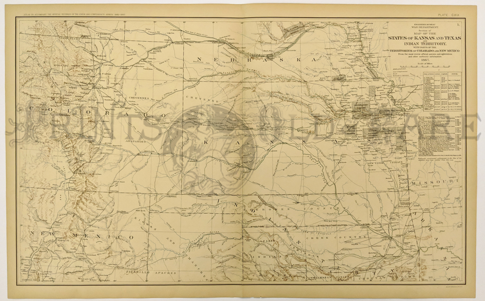
214ks:
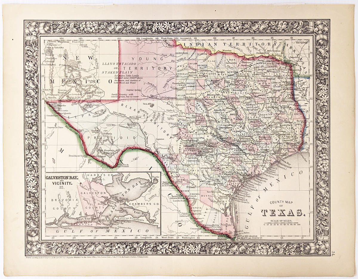
1867 Engraved Map of the States of
Kansas and Texas and Indian Territory, with parts of the Territories of
Colorado and New Mexico. Published by the War Department Engineer
Bureau.
29 x 18 in. $150
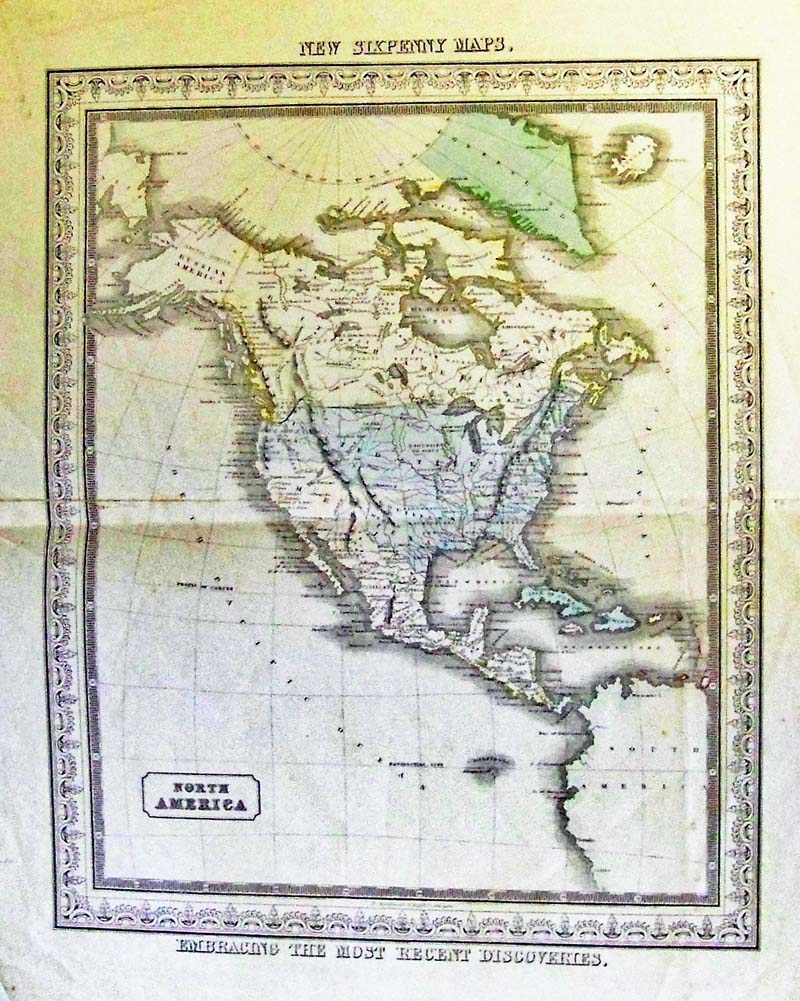
227nam:
c. 1850 North America New Six Penny
Map by D. Macdonald, Glasgow. This is an original, color engraved map.
Note: Interesting feature: This map details after Texas became
independent and before the California Revolution. Territory shown is
the Oregon Border and Russian America, Texas in the U.S. and California
and
Southwest still in Mexico.
18-1/2 x 15 in. $325
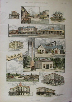
350tx:
Views
In Texarkana, Arkansas and Texas. This hand colored wood engraving is
from the May 3, 1890 edition of Frank Leslie's Illustrated Newspaper.
It shows scenes of: Office of J. Duetschman, Broad Street, residence of
W.A. Kelsey, Union Depot, Cosmopolitan Hotel, Texarkana Ice Co., Water
Works, Kizer Lumber, Benefield Hotel, O.P. Taylor Real Estate, and
Huckins House. 11x16 in. $70
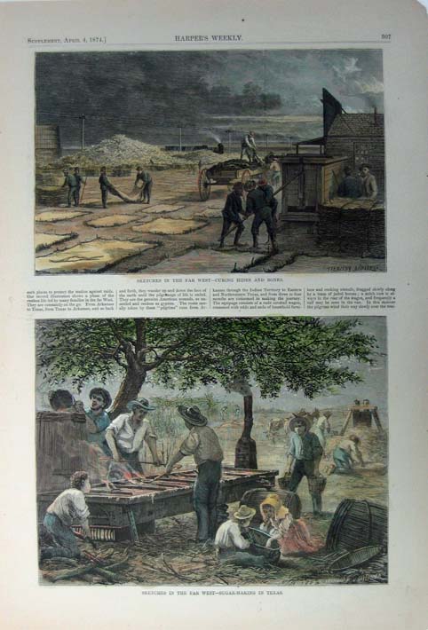
358tx:
1874
Hand colored wood engraving titled, "Sketches in the Far West-Curing
Hides and Bones and Sketches in the Far West- Sugar Making in Texas,"
drawn by Frenzeny Tavernier from Harper's Weekly. 11 x 16in. $60
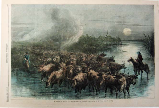
361tx:
1867
Hand colored engraved image titled, "A Drove of Cattle Crossing a
Stream," drawn by R. Ward from Harper's Weekly. Shows a dramatic scene
of cattle and cowboys crossing a stream.
11 x 16 in. $80
376tx:
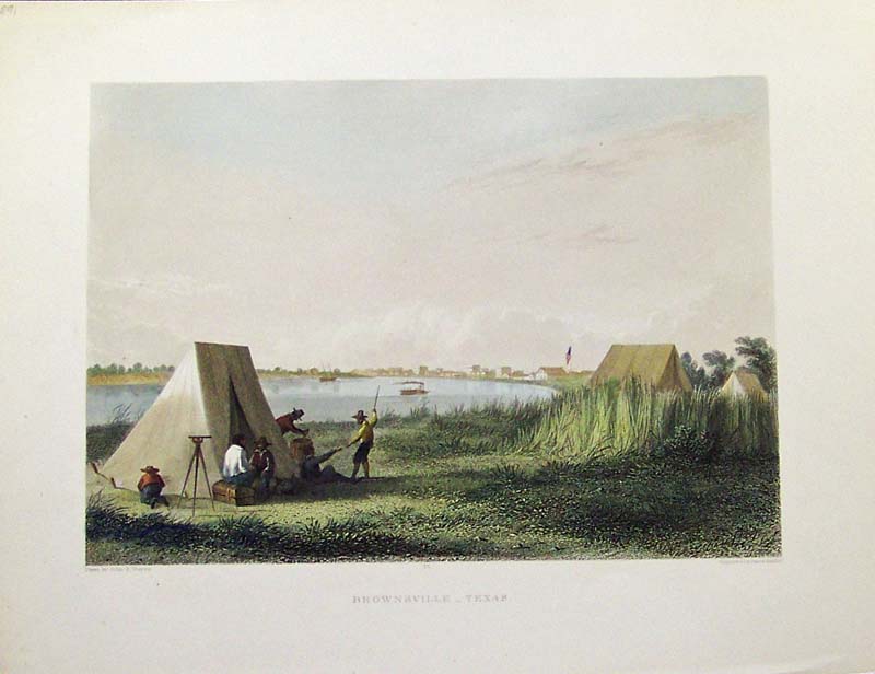
Brownsville. 1858 rare hand colored steel engraving from
Mexican Boundary Survey. Fine condition in a beautiful
French mat.
11-1/4 x 8-1/2 in. $150

383tx:
James Polk. c.1860 Hand colored steel engraving. The Annexation of
Texas. Vignette.
9-1/2 x 6-1/2 in. $60
384tx:
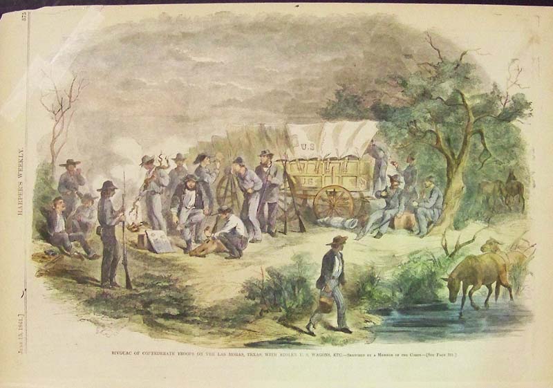
1861 Confederates in Texas. Hand colored wood engraving titled,
"Bivouac of Confederate Troops on the Las Moras, Texas, With Stolen
U.S. Wagons, Etc." Featured
in Harper's Weekly.
Fine condition.
15-1/2 x 11 in. $80
386tx:
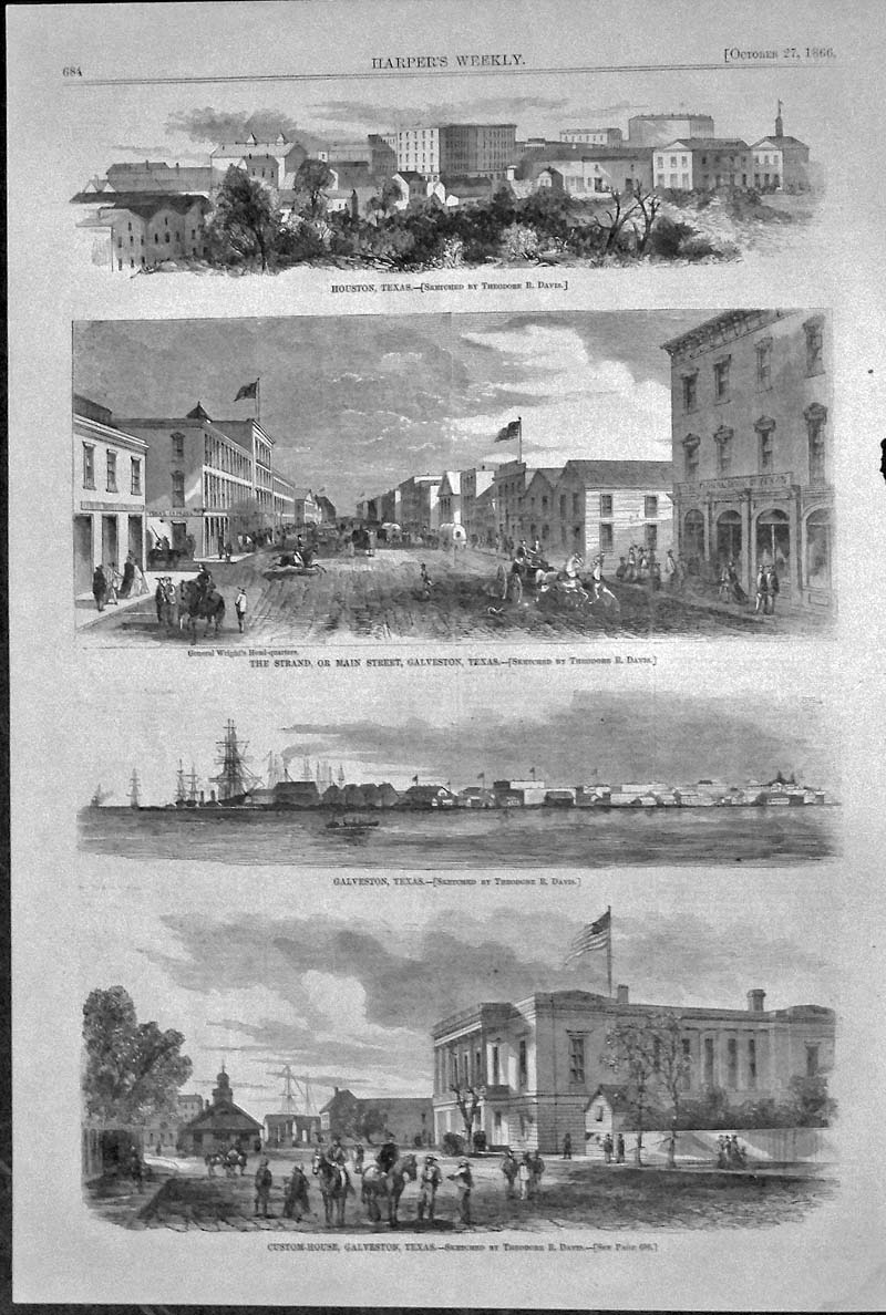
1866 Houston and Galveston. Wood engraving in fine condition showing
four vignettes of Houston, The Strand in Galveston, and a Custom-House
in Galveston.
16 x 11 in. $80
SOLD
387tx:
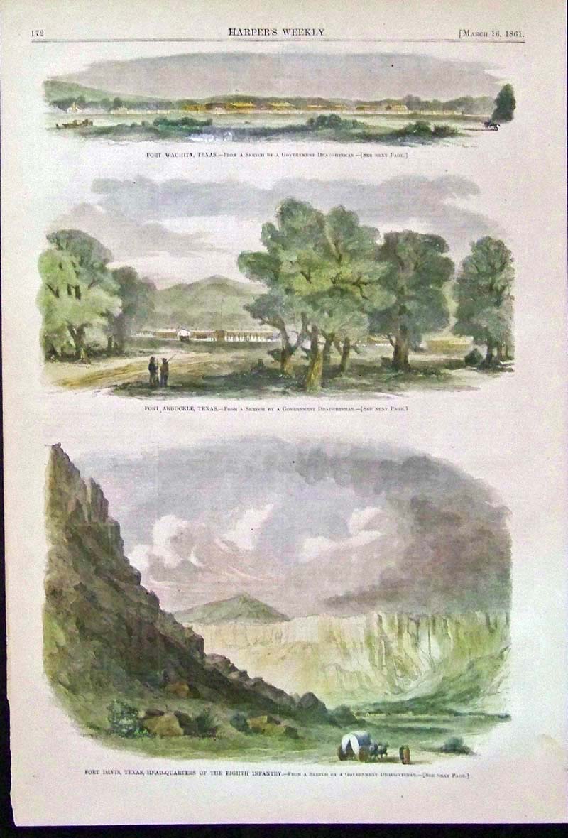
1861 Confederate Forts -- "Fort Davis, Texas, Head-Quarters of
the Eighth
Infantry," and Fort Wachita, Texas, and Fort Arbuckle, Texas
in three
images. Hand colored, wood engraving.
16 x 11 in. $60
389tx:
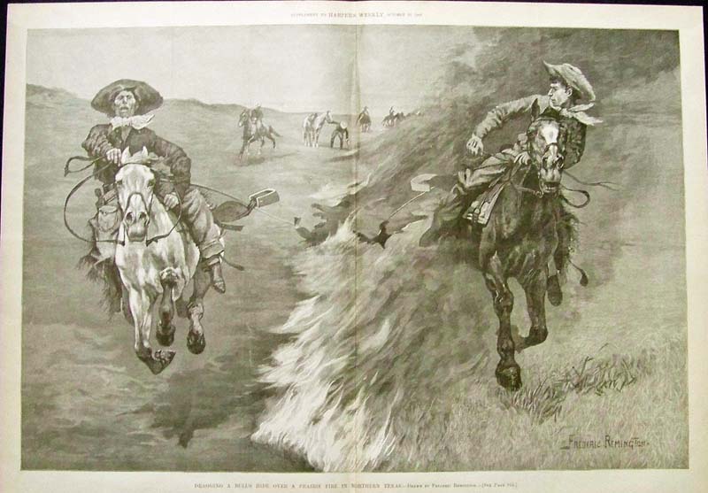
1888 Exciting Frederic Remington wood engraving titled, "Dragging A
Bull's Hide Over A Prairie Fire in Northern Texas." From
Harper's
Weekly.
22 x 15-1/2 in. $300
390tx:
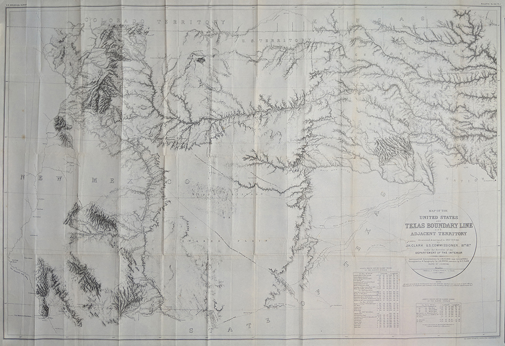
Texas Map of the United States and Texas Boundary line &
Adjacent Territory. (Surveyed 1857-60) Published 1902. Dept. of
Interior. NW Boundary of Texas w/ Mexico, Colorado, & Kansas.
Very Detailed showing forts, explorer routes, Indian trails, etc.
39 1/2 x 26 1/2 $395
|
|