 
|
|||||||||||
This is a small selection of our inventory of antique Wall and Rolled Maps. Additional inventory is available. Lowest Prices! Contact us with your request. 1-800-879-6277
|
|||||||||||
|---|---|---|---|---|---|---|---|---|---|---|---|
 rdm_1: 1845 Mitchells National Map of the American Republic or United States of North America Together with Maps of the Vicinities of 32 of the Principal Cities and Towns by Mitchell; Philadelphia showing United States East of Mississippi River Also states: Louisiana, Arkansas, Missouri; territories of Iowa, Wisconsin Parts of Dakotah (or Sioux Indians), Indian Territory and Texas. 32 side insets of principal city from every state & D.C. also insets on map showing top of Maine; the North East boundary of US & bottom of Florida. Beautiful scroll border, eagle in each corner. Table inset showing population of each county & the different states & territories. Green coded table lists white & black population Pink coded table lists city population Linen backing. Condition: Water damage on right side 4-6 inches into map showing most at top quarter otherwise map is in good condition. 41 x 50 in. $4,500 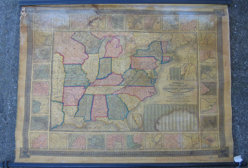
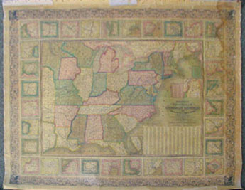
rdm_2: Mitchell's National Map of the American Republic or United States of North America Together with Maps of the Vicinities of 32 of the Principal Cities & Towns, 1843. Published by Mitchell, Philadelphia. Showing the United States East of Mississippi River, Louisiana, Arkansas, Missouri; Territories of Iowa, Wisconsin, Parts of Dakotah (or Sioux Indians), Indian Territory & Texas . Thirty two side insets of principal city from every state & D.C. also insets on map showing top of Maine; the North East boundary of the United States & bottom of Florida. Beautiful greek key border, eagle in each corner. Table inset showing population of each county & the different states & territories. Linen backing in fair condition (map is complete), whitened at top upper right & left Water damage, some paper missing on left border to edge of map not affecting image. 41 x 50 in. $3,500 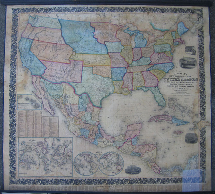
rdm_3: Mitchells New National Map, exhibiting the United States with the North American British Provinces, Sandwich Islands, Mexico and Central America, Together with Cuba and West India Islands, 1856. Published by S. Augustus Mitchell, Philadelphia - Constructed & engraved by W. Williams. . Insets: Mercator World / Hemisphere World, Sandwich Islands, distance table, water routes, length of rivers, height of mountains. Engraving of clipper ship Flying Cloud, Columbus ship, an American steamship & the landing of the Pilgrims. Below bottom border is chart listing the population of each county in the US according to 1850 census, also names county town. Restored linen backing, some staining on left and right, a few cracks , overall very good with wide floral border. 65 x 63 in. $5,000 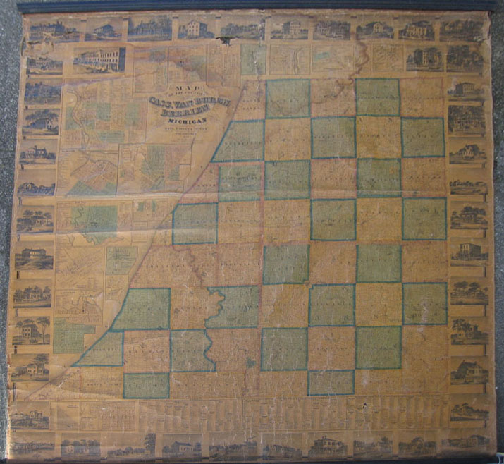
rdm_4: Antique Map of the counties of Cass, Van Buren and Berrien Counties, 1860. Published by Geil, Harley & Siverd, Philadelphia From special surveys & official records by Geil & Jones Topographical engineer. This huge wall map shows 44 residences and buildings displayed as border of map in Niles, St. Joseph, Buchanan, Dowagrae, Cass, etc. city inserts Niles, St. Joseph, Paw Paw, Dowagiac, Breedsville Decatur Lawrence, La Grange, Buchanan, Lawton, Cassopolis, Coloma, Berien, Edwardsourgh, Matawan, New Buffalo. Map insets also include charts, Tables of Distances, Business Directory of Country Subscribers by town (farmers, lumbermen, sawmills primarily). Overall toned, water damage center & left top, hole under top 5th picture from left and damage to 2 top left pictures. 66 x 62 in. $1,000 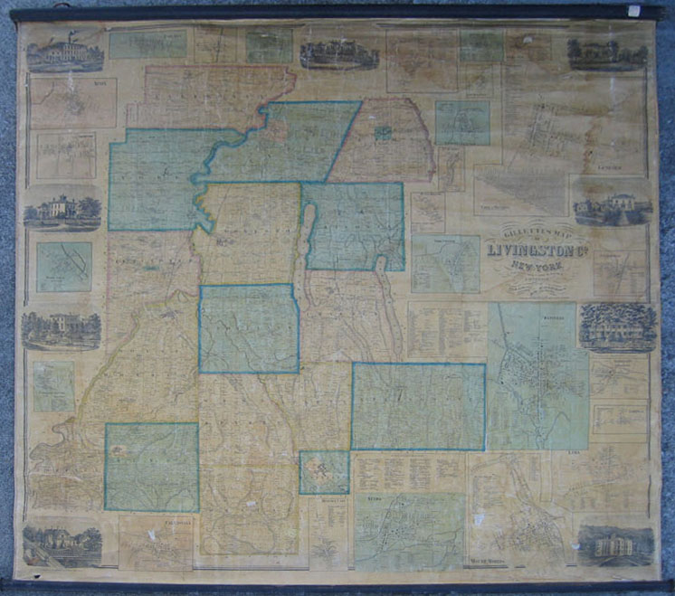
rdm_6: Gillette’s Map of Livingston Co., New York from actual Surveys unter the direction of J.H. French Syracuse, 1858. Published by Jno. E. Gillette, Philadelphia. Showing all townships of Livingston County with insets of cities of Mt. Morris, Dansville, Inverness, Lakeville, Lima Nunda, Hemlock Lake, Caledonia, Conesus Center, Woodville, Moscow, Avon, East Avon, Piffardina, Scottsburgh, Springwater, Livonia Station, S. Livonia, Livonia Centre, Oakland, Tuscarora, Hunts Hallow, York Center, Cuylerville. There are 9 engraved views along the map edges and a large inset of Geneso includes a business directory. The final inset is a table of distances . Fair to good condition, toned with evidence of some water damage on side and top center 7 scattered missing pieces – all small approx. ½ – 2. 60 x 60 in. $800 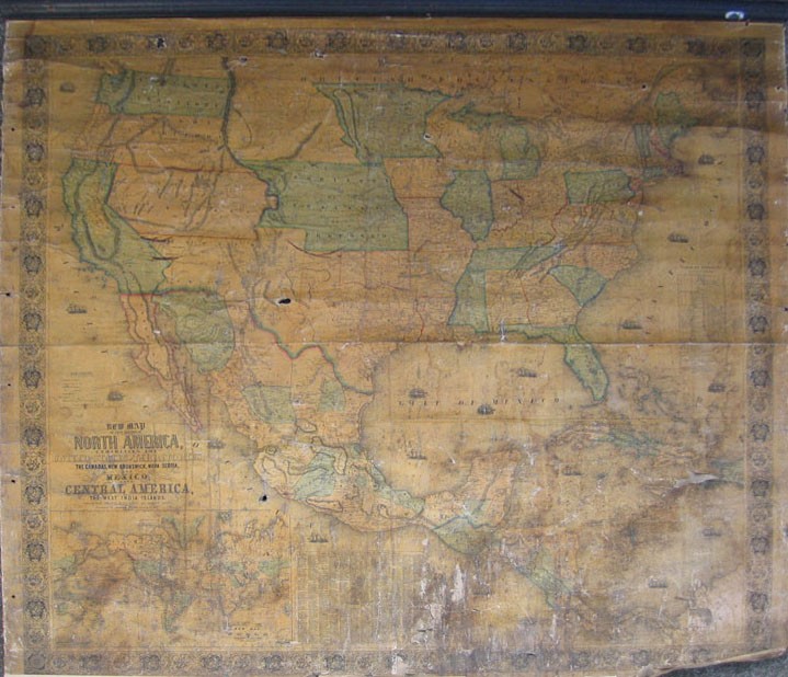
rdm_9: New Map or that Portion of North America, exhibiting the United States & Territories, the Canadas, New Brunswick, Nova Scotia & Mexico and Central America and the West India Islands compiled from the most recent surveys & authentic sources, 1853. Published by Jacob Monk, Baltimore, Maryland. Capitals of state and county seats, railroads finished & unfinished, stage roads, canals are all shown along with insets: world map with trade routes, county towns. Territory of Nebraska, Utah, Oregon, Washington, Dakota. 7 holes, toning splitting, missing pieces West Indies, South America Size: 58 x 62 in. $4,500 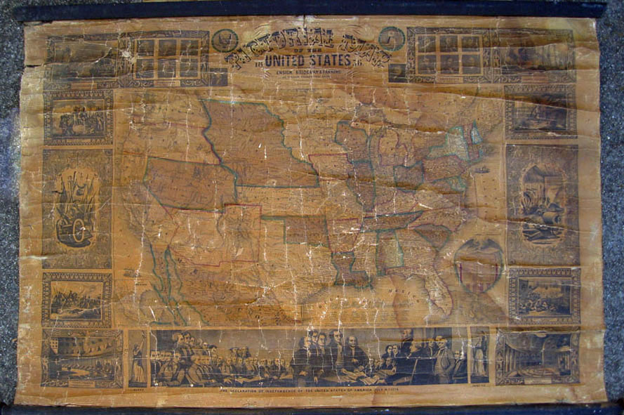
rdm_10: 1856 Pictorial Map of the United States. Published by Ensign, Bridgman & Fanning (William Street, New York). Wide border with engraved patriotic vignettes: i.e. Senate Chamber, Declaration of Independence, Capture of General La Vega, Constitution & Guerriere, Presidents, Liberty, Battle of Monterey. Inset of a Map of Mexico, population table 1850. Utah extends all the way to California. Also showing the Great Interior Basin, Minnesota Territory, Nebraska Territory (this area today includes Montana, Indiana, Wyoming, North and South Dakota) Puebla des Los Angeles, New Mexico (No Arizona) Indian Territory. Folds, cracks, scattered missing pieces. Size: 30 x 44 in. $1,200 |
rdm_13: 1910 Scarboroughs Map of California Showing Counties, Townships, Cities, Villages, Post Offices, Principal Highways, Railroads & Stations with distances between electric Rys, Government and State Reservations completely indexed. Published by Scarborough Co. Indianapolis. Shows insets of 1910 population, distance table, Los Angeles area, San Francisco Bay Area, county seats. Discoloration on top of map & border. Otherwise very good condition. Size: 51 x 40 in. $400 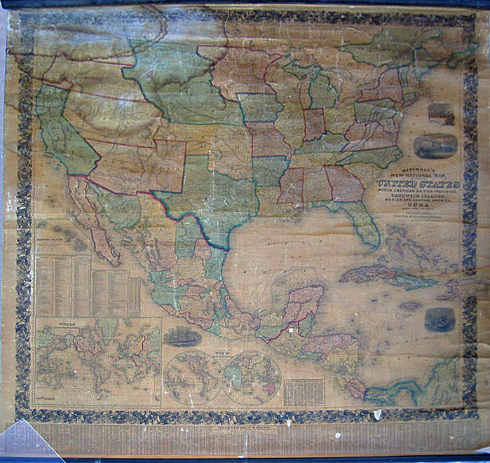
rdm_15: Mitchell's New National Map, exhibiting the United States with the North American British Provinces, Sandwich Islands, Mexico and Central America, Together with Cuba and West India Islands, 1857. Published by S. Augustus Mitchell, Philadelphia, Constructed & engraved by W. Williams. Insets: Mercator World / Hemisphere World, Sandwich Islands, distance table, water routes, length of rivers, height of mountains. Engraving of clipper ship Flying Cloud, Columbus ship, an American steamship & the landing of the Pilgrims. Below bottom border is chart listing the population of each county in the US according to 1850 census, also names county town. Surrounded by a wide floral border. All west of Mississippi still territories with states of California & Texas Territories of New Mexico, Utah, Kansas, Indian Nebraska, Dakota, Oregon & Washington. Water damage top left & center , pieces missing from lower border, overall good condition . Size: 67 x 64 in. $4,000 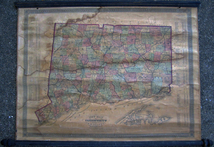
rdm_16: 1871 New Map of Connecticut. Published by S.D. Tilden, Hartford. Inset of each old county with towns listed with population in 1860 & 1870. Townships are indicated with railroad lines & steamship lines. Overall toned; water damage thru center of map & left side. Two small holes near top above border. Size: 21 x 29 in. $500 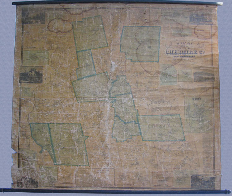
rdm_17: 1858 Map of Cheshire County New Hampshire from actual survey by L. Fagan. Published by Smith & Marley, Philadelphia. Inset maps of: Finseale, Stoddard, Mill Village, Ashuelot, Troy , Chesterfield Factory, Keene, Winchester, Chesterfield, West Swanzey, Fitzwilliam, Lowellville, Marlborough, Walpole, Harrisville. Inset tables: churches, populations, businesses, distances. Inset pictures: Walpole, Eagle Hotel, Monadnock Mt. & Lake hard to identify school building on far left corner, Cheshire House in Keene & view of Main St. from the South, Keene. Towns: Nelson, Westport, Jaffrey, Paper Mill Village, Westmorland, Marlow, Munsonville, Unionville . Poor condition, water damage, missing piece 4x3 in center, worn spots, chipping. Still a very rare find! Size: 55 x 58 in. $700 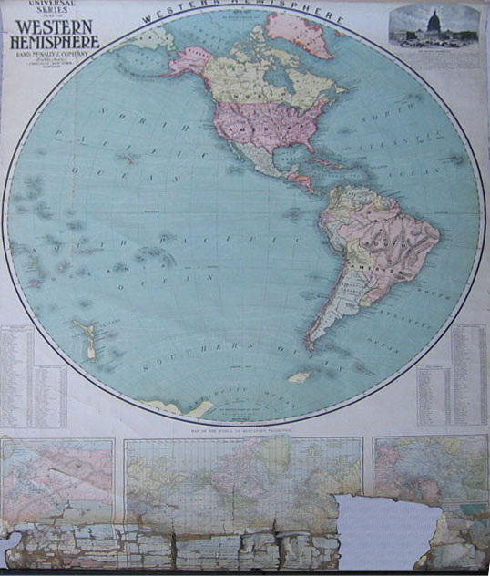
rdm_19: 1911 Universal Series Map of the Western Hemisphere . Published by Rand McNally, Chicago. Political map of North America and South America. Inset: Population of 100 foreign cities & 100 U.S. cities (1910). Inset of Capitol upper right hand corner. Map also shows Ocean currents. South Pole 6 months of darkness December 14, 1911 Amundsen. Fair condition; crack from top of map for 25; loose pieces. Size: 40 x 40 in. $125 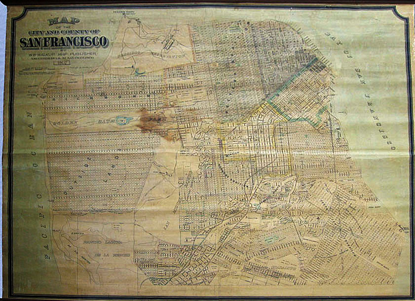
rdm_20: 1902 Map of the City and County of San Francisco. Published by W.B. Walkup, San Francisco. Map of subdivision and some notable buildings, San Miguel Rancho, Rancho Laguna de la Merced. Current Sunset District shown as Outside Lands. Rare Map of a Pre-1906 Earthquake City of San Francisco. Very good condition except for brown stain in the center of the map. Size: 51 x 63 in. $2,000 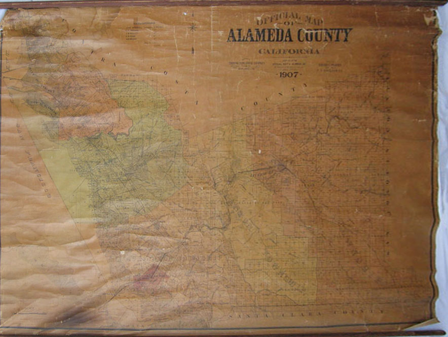
rdm_21: Official Map of Alameda County California adopted by Board of Supervisors, 1907. Published by Compiled by Edward C. Prather, Tribune Publishing Co. Schmidt Litho Co. San Francisco. Shows subdivisions, townships, rancho, school districts. Fair; overall toned; brown stain lower left scattered missing pieces, small hole upper center. Size: 49 x 79 in. $900 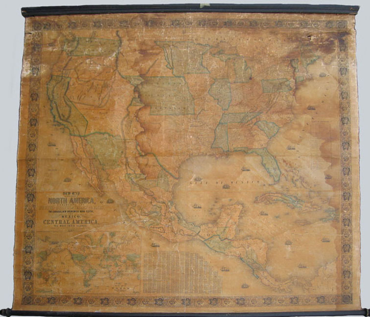
rdm_22: New Map or that Portion of North America, exhibiting the United States & Territories, the Canadas, New Brunswick, Nova Scotia & Mexico and Central America and the West India Islands compiled from the most recent surveys & authentic sources, 1853. Published by Jacob Monk, Baltimore, MD. Capitals of state, county seats, railroads finished & unfinished, stage roads, canals. Insets: World map with trade routes, county towns. Territory of Nebraska, Utah, Oregon, Washington, Dakota also shown. "Gold Region" California Sierras . New Mexico, Washington, Oregon Territory / Territory of Nebraska as Proposed Dakotas & Minnesota area + Minneatares/ Mandans, Arickarees. Water stain down center of map & on right side hole in Eastern Canada discoloration, wearing, stains . Size: 58 x 62 in. $4,500 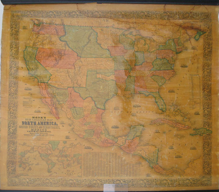
rdm_23: New Map or that Portion of North America, exhibiting the United States & Territories, the Canadas, New Brunswick, Nova Scotia & Mexico and Central America and the West India Islands compiled from the most recent surveys & authentic sources, 1856. Published by Jacob Monk, Baltimore, MD. Capitals of state, county seats, railroads finished & unfinished, stage roads, canals. Insets: World map with trade routes, county towns, The "Gold Region" California Sierras; many Gold Rush towns listed West consists of territory of Nebraska, Utah, Oregon, Washington, Dakota, Kansas, New Mexico, Oklahoma is Chaah Lah Kee & Chah Ta. Great condition water stain right corner. Size: 60 x 63 in. $4,500 |
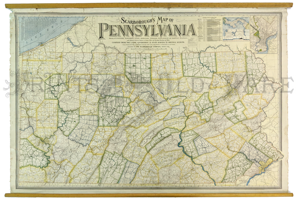
163Pennslyvania: 1904 Scarborough's Map of Pennsylvania. Showing all counties, townships, cities, boroughs, villages, post-offices and rail-way stations.Rail lines, suburban electric lines, and a few highways are shown. Large wall map is made of oil cloth material and has wooden rollers top and bottom. Verso contains 1900 census information about the state's population and a gazetteer keyed to a grid around the map edge. Top shows insets of Philadelphia and Panama, plus a legend and milage table 38 1/2 x 53 in. $450 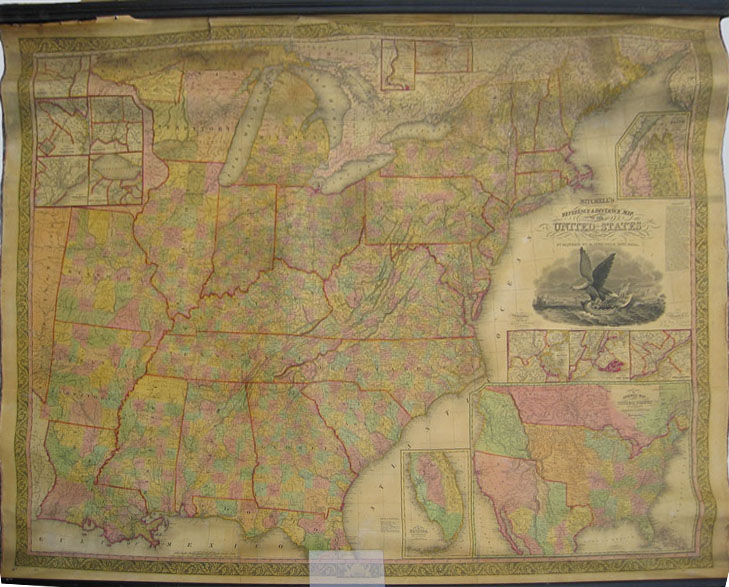
rdm_24: Mitchell's Reference & Distance Map of the United States by J. H. Young, 1836. Published by Augustus Mitchell. Inset: Whole US showing Western Territories: Missouri & Oregon. Whole Southwest still part of Mexico. Inset: South part of Florida / Boston / New York / Philadelphia / Main boundary. Vicinity of New Orleans, Charleston, DC, Cincinnati, Albany. Also shows the Census of 1830. Newly backed on linen, very good condition, minor rips and tears (tear in the top middle border, some aging and discoloration; small hole in Lake Michigan). *Top frame mount has been removed. Will be included with purchase. * Contact us for pictures. Size: 54 x 71 in. $4,500 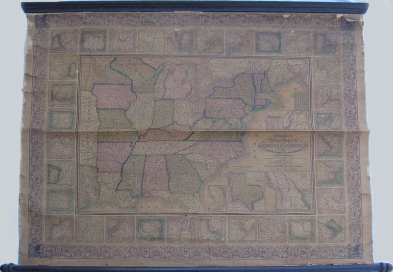
rdm_28: National map of the America Republic or United States of North America Together with Maps of the Vicinities of 32 of the Principal Cities & Towns, 1848. Published by Mitchell; Philadelphia. Beautiful scrolled border with eagles at corners . Chart of population of cities & towns. Extremely detailed with 32 major city maps shown as well as many of the states still as territories. Needs gluing, cracks and chips, but complete, aged toning. Size: 41 x 49 in. $1,000 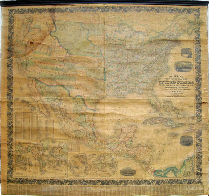
rdm_29: New National Map of the United States, North American British Provinces, Sandwich Islands, Mexico & Central America together with Cuba and the West India Islands, 1850 . Published by Augustus Mitchell; Philadelphia . Extremely rare inset showing the Population of Each County in the United States 1850 census. Map of World Mercator Projection. Map of Globular Projection. Distance Table by land & water routes, lengths of rivers, heights of mountains . Map of Sandwich Islands. Great map of the West including Washington, Oregon, Nebraska, Utah, California, Texas, Kansas & Indian Territories. There are no states of Nevada, Arizona, Oklahoma or Minnesota shown on this map at this time. Fantastic map in relatively good shape some pieces on edges are coming loose, some chipping , but overall good . Size: 66 x 62 in. $2,000 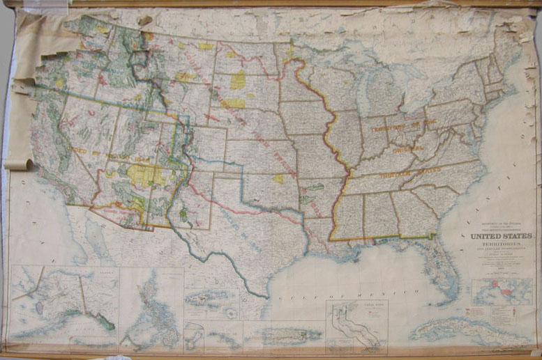
rdm_30: 1909 United States Including Territories & Insular Possessions. Published by Department of the Interior. Indians, Military & Forest Reservations, Railroads, Canals, National Parks & other details, dates of acquisitions of territories. Insets: Alaska, Philippines, Puerto Rico, Canal Zone, Hawaii. Condition is rough, needs to be glued and mended.. Bottom is clean and bright. Size: 58 x 80 in. $300 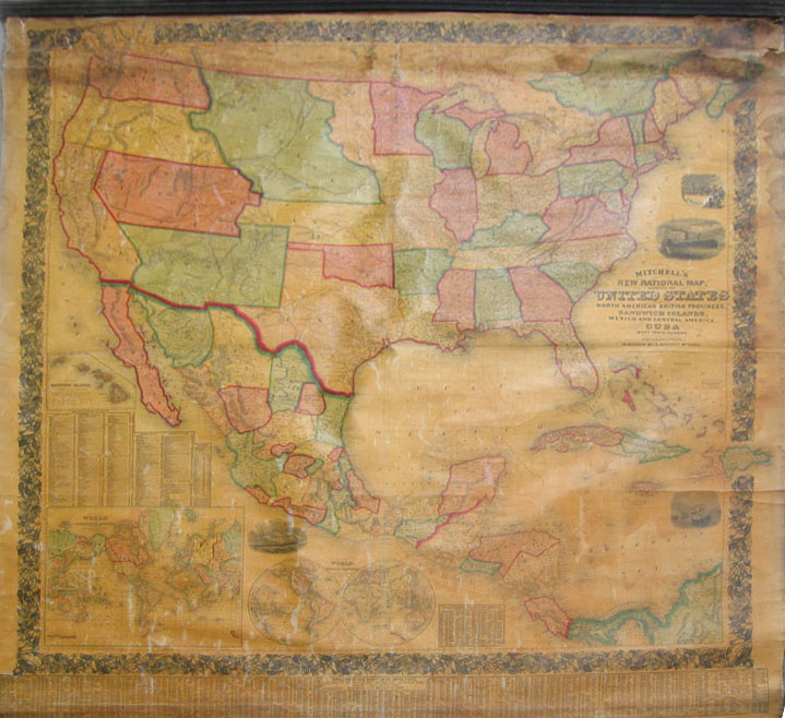
rdm_31: New National Map of the United States, North American British Provinces, Sandwich Islands, Mexico & Central America together with Cuba and the West India Islands, 1850. Published by Augustus Mitchell; Philadelphia. Extremely rare inset showing the Population of Each County in the United States 1850 census. Map of World Mercator Projection. Map of Globular Projection. Distance Table by land & water routes, lengths of rivers, heights of mountains . Map of Sandwich Islands. Great map of the West including Washington, Oregon, Nebraska, Utah, California, Texas, Kansas & Indian Territories. There are no states of Nevada, Arizona, Oklahoma or Minnesota shown on this map at this time. Condition good. Some chipping at edges; damage to right top corner deteriorated. Map on new linen. Size: 66 x 62 in. $2,000 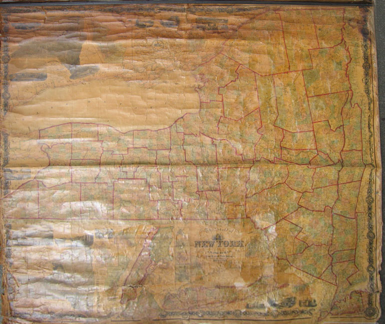
rdm_33: The State of New York from New & Original Surveys under the Direction of J.H. French, 1859. Published by Robert Pearsall Smith, Syracuse NY . Inset: Land Patent map, New York City Area, Meteorological Map. Vignettes of State Agriculture College, West Point, NY State College, Syracuse, Oswego, Albany, Poughkeepsie, Schenectady, Hudson, Utica, Portage Bridge, City of New York, Genesee Falls. Clocks showing different times when it is noon at Albany. Damage to top & bottom. Size: 67 x 73 in. $1,500 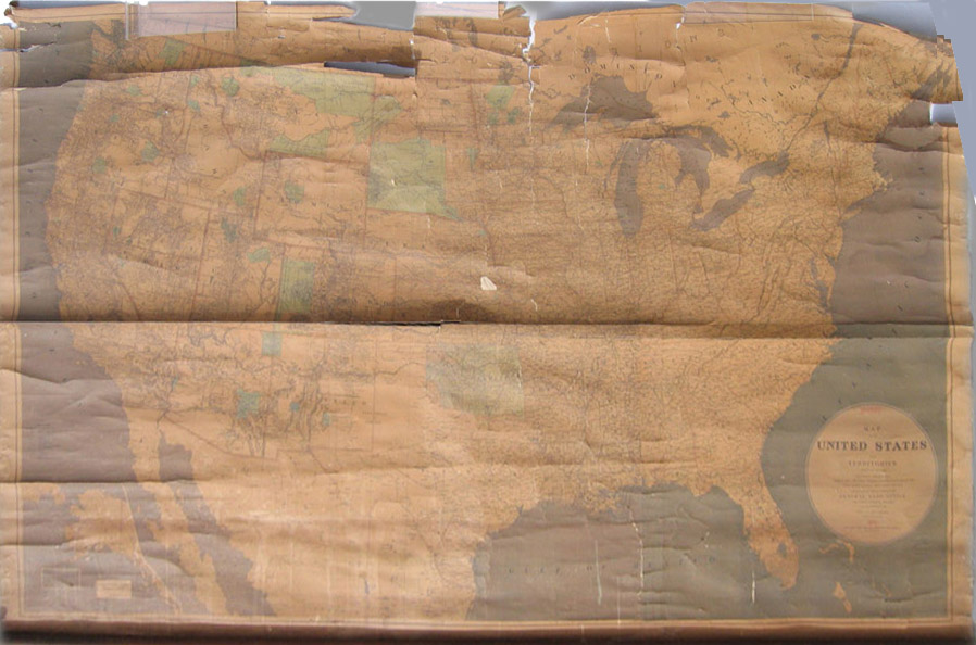
rdm_34: Map of the United States & Territories Showing the extent of the Public Surveys, Indian & Military, 1876. Published by General Land Office . In poor condition. Size: 49 x 79 in. $300 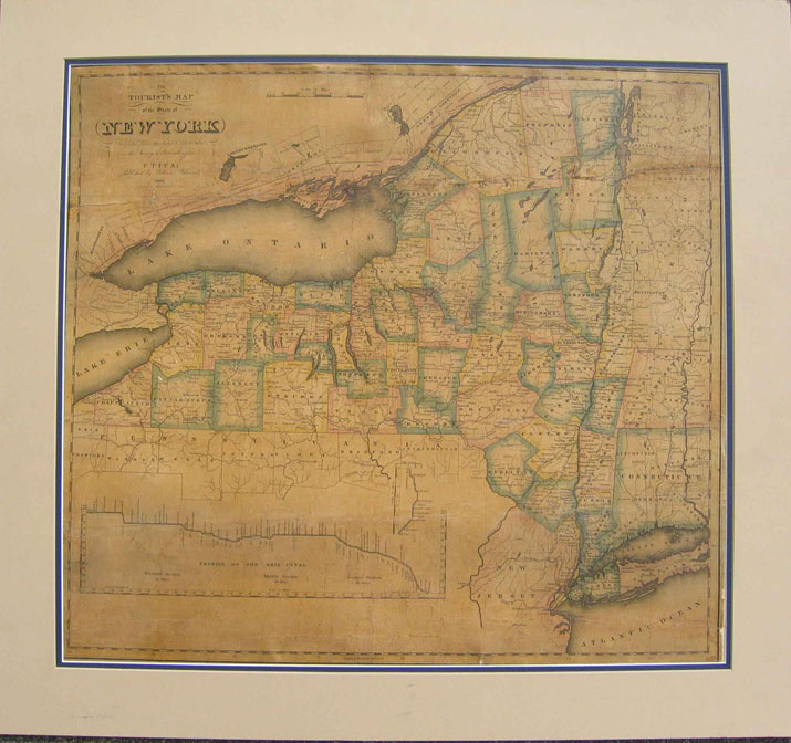
rdm_35: The Tourists Map of the State of NY compiled from the latest authorities in the Surveyors General's Office, 1828. Published by William Williams; Utica, NY. Includes profile of the Erie Canal. Mounted on linen, several repairs. Size: 20 x 22 in. $400 Check for Availability |
|||||||||
| Order Form | |||||||||||
| Back to Homepage | |||||||||||