002ceur:
Kpol Jan Sobieski pod Wiedniem- This is a vibrant chromolithograph
showing the King of Poland and the Grand Duke of Lithuania
near Vienna.
20 x 15 in. $120

003ceur:
1911
Map of the Austro-Hungarian Empire, by George F. Cram. Antique map
title is "The Austro-Hungarian Monarchy and its Protectorates Bosnia
and Herzegovina." Each nation within the empire is colored separately.
A small inset map shows the southern portion of Dalmatia and
Herzegovina. 15x22 in. $60

004ceur:
1892
View: The Ampitheater in Pola, Austria. Nice woodcut engraving of a
scene in Pola, looking down on the city with the ampitheater on the
right. Published as an illustration to a book.
9x11 in. $30

005ceur:
1869
Map of Central Europe. Hand colored map from a geography text, showing
an area from the German states in the west to European Turkey in the
east. Switzerland, Italy, Austria and Greece are also included. 10x12
in. $40

006ceur: 1897
Map of Central Europe from the Century Atlas. Focuses on the German
states and Austria-Hungary, but also includes France, the Low
Countries, England, Switzerland and northern Italy.
12x16 in. $30

008ceur:
1864
Johnson's Map: Austria, Turkey in Europe and Greece. Beautifully hand
colored, engraved map from the 1864 edition of Johnson's Family Atlas.
Includes a small inset map of the island of Candia in the lower right.
There is also a small engraved view of the city of Constantinople.
Entire map image is surrounded by a decorative border.
18x26 in. $80

010ceur:
Circa
1880 map of the countries surrounding the northern Adriatic Sea, from
Stieler's Hand-Atlas. Extremely detailed, engraved map with original
outline hand coloring. In the lower left corner there is an inset map
of Vienna and vicinity.
15x19 in. $40

011ceur:
1915
Rumania Bulgaria Turkey Map. Color map by George F. Cram showing
cities, towns, railroad lines and geographical features. Also shows the
locations of submarine telegraph cables. 11x15 in. $30

012ceur:
1885
Greece, Turkey, Balkan States Map. Color map by J. Bartholomew,
published in a late 19th century world atlas. Map title is "Turkey in
Europe, Greece, Roumania, Servia, Etc."
11x14 in. $50

014ceur:
1880
Central European Modes of Dress. Color lithograph published as an
illustration to a German book on costumes circa 1880 shows how the
common people dress in Georgia, Albania, Romania and Poland.
7x10 in.
$40

015ceur:
1854
Map of Hungary, Surrounding Area. Engraved, hand colored map from K.V.
Spruner's Historical Atlas. Hungary at the time was much larger than it
is today, and this map shows it covering that larger area. In the upper
left corner, there is a small inset map showing the country's religious
divisions between the Roman Catholic and Greek Orthodox churches. 14x18
in. $100

016ceur:
1838
Bradford Map: Central, South Europe. Beautifully hand colored map from
T.G. Bradford's famous world atlas of 1838. This map is from the 1846
printing of the atlas, and the phrase "corrected to 1846" appears below
the bottom border. Countries shown are Germany, Austria, Prussia,
Switzerland, Italy, Greece and Turkey. Cities and geographical features
are shown throughout the region.
13x17 in. $200

019ceur:
US
Revolutionary War: Kosciuszco of Poland. Colorful, lithographed
calendar published circa 1925 by the Novelty Calendar &
Printing
Co. of Fall River, Mass. Contains portraits of Revolutionary War heroes
George Washington and Thaddeus Kosciuszko, with the US and Polish flags
crossed above them.
15x20 in. $80

200ceur:
RARE
Old Homann Heirs Map of Austria. This beautifully engraved, hand
colored map is titled Circulus Austriacus quem componunt Archid,
Austriae, Ducatus Stiriae, Carinthiae, Carnioliae, Comit, Tyrolensis,
ditionesque Sueviae Austraie. It was drawn by Tobias Majer, and
published by Homann Heirs in 1747. The map is extremely detailed. It
shows the western part of what was then the Austrian monarchy,
comprising Austria, Bohemia, Moravia and Northeast Italy. The map title
is surrounded by a beautiful design, which includes the coats of arms
of five Austrian districts. In the lower right corner, there is a map
key which is also surrounded by a decorative border. This map is in
very good condition, with no
significant blemishes.
22x25 in. $600
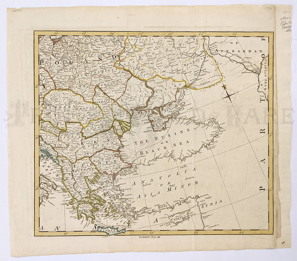
287rus: Balkans, S. Russia 1774 –
Asia Minor Hand colored copper engraving map. Includes Black Sea,
Crimea, Middle East & Anatolia.
16 ½ x 18 3/8 in. $150
|

201ceur:
Early
Antique Map of Poland: 1772. Interesting, engraved map, titled "A Map
of Poland with its Appendages, Shewing the Late Partition of that
Kingdom." Printed in the Nov. 1772 issue of Gentleman's Magazine, an
English periodical. The country is shown divided into small provinces,
whose boundaries are marked with dotted lines. Cities and towns are
shown, as well as geographical features. This map is in excellent
condition.
8x9 in. $60

203ceur:
1752 Prague - Bird's-Eye View hand colored copper engraving in fine
condition.
15 x 9 in. $150

205ceur:
1775 Homann Heirs Map of South Poland. Very
detailed, decorative map, titled "Lubomeriae et Galliciae Regni, Tabula
Geographica." Published in 1775 by Homann Heirs. Shows an area that is
now southern Poland. In that year, much of South Poland was given to
Austria. This map shows the locations of metal ore deposits in the
Austrian's newly acquired territory, and was useful to the new Austrian
lords who wanted to make money in their new land. Title is surrounded
by an elaborate cartouche. Nicely hand colored, in very good condition.
21x26 in. $600

207ceur:
1749 Map of Poland, Lithuania. Uncolored
copper-engraved map, printed in 1749. No cartographer's name given,
possibly by Senex. Title is "A New Map of Poland from the latest
Observations." Shows the Polish kingdom (including Lithuania) at its
largest size. Poland has never controlled more land than it did during
the year this map was published. Several very small spots of foxing
near the top . Otherwise very good condition.
8x9 in. $75

208ceur:
18th Century Map: Balkans, South Ukraine. Undated,
engraved map titled "Seat of War Between the Russians, Poles and
Turks." Published by the London Magazine, mid-1700s. Shows an area from
the Eastern Balkans to the Southern Ukraine. Nicely hand colored. Right
margin is trimmed to the map border. Otherwise very good condition.
8x11 in. $100

210ceur:
1801 Map of Austrian Territory by Cary. Engraved map, with original
hand coloring, published in 1801 by J. Cary. Title is "A New Map of the
Circle of Austria from the Latest Authorities." Includes Austria
itself, as well as the territory extending south to the Gulf of Venice.
Small amount of foxing in the left margin. Otherwise very good
condition. $350

211ceur:
1799 Map of Switzerland by Cary. Engraved map, with
original hand coloring, published in 1799 by J. Cary. Title is "A New
Map of Swisserland, Divided into its Cantons and Dependencies,
Including the Grisons, etc. etc." Switzerland is shown divided into
thirteen cantons. Map is in
excellent condition.
22x26 in. $400

212ceur:
1781 Bonne Map: Germany, Hungary, Central Europe. Hand
colored, engraved map of Germany and Central Europe, published in 1781
by Rigobert Bonne. Title is "L'Allemagne, la Boheme, et la Hongrie:
Avec un Partie de la Pologne." Shows cities, geographical features and
political boundaries. Several small but noticeable dark stains on image
and lower margin. Otherwise very good condition. 10x16 in. $100

213ceur:
1720 Map of Silesia, by C. Weigel. Hand colored,
engraved map of Silesia, published in 1720 by C. Weigel. Title is
"Silesiae, Ducatus in XVII suos Principatus et Dominia." Title is
surrounded by an elaborate cartouche. A decorative scene is in the
lower left
corner of the map.
14x17 in. $300

214ceur:
1720 Map: Transylvania, Romania. Nicely engraved
map, with original hand coloring, titled "Fines Hungariac Victoriis
Caroli VI?." Drawn by Kauffner, and published in 1720. The map focuses
on Transylvania, which is now part of Romania. A smaller map in the
upper right corner shows a
battlefield in Serbia.
14x17 in. $350

215ceur:
1598 Ortelius Map of Austria. Beautiful, decorative
map of Austria, published by Ortelius in 1598. Nicely colored, with
original hand coloring. Title is "Austriae Descrip. Per Wolfgangum
Lazium." Title is surrounded by a colorful cartouche. Mileage scale and
map border are both elaborately decorated. The margins of this map are
chipped, with many small tears, but the image is not affected. The
entire image is clean and clear. The map has been archivally mounted on
acid-free paper to prevent tears and chipping. It would look great in a
frame!
14x19 in. $750

218ceur:
Kingdom of Hungary and Transilvania. Detailed topographical map showing
towns and rivers. Figures of Kings on side of map key. 1744 Bowen. A
New and accurate map of the Kingdom of Hungary and the Principality of
Transilvania with bordering countries. Hand colored copper engraving is
titled, Drawn from the best authorities assisted by the most approved
Modern Maps. The whole being adjusted by Astronomical Observations by
Eman Bowen.
13.5x16.5 in. $150

219ceur:
J.H. Colton map of Central Europe. Printed in 1860,
this hand colored map shows Prussia, Austria, Turkey and Italy. 13.5 x
11 in. $60

220ceur:
C.1820 Copper engraved Carey Map of Poland & Lithuania showing
Russia, early Prussia and Austria. Light brown stain on upper right
border extending a little bit
into top right corner.
17 x 13 in. $250

221ceur:
1833 Lightly hand colored steel engraved map of Vienna (Wien) in fine
condition. Bottom of map shows the comparison of heights of prominent
buildings. Map is published under the Superintendence of the Society
for the Diffusion of Useful Knowledge (S.D.U.K.). Map is published by
Chapman & Hall, London.
16 x 13-1/2 in. $200

222ceur:
1786 Hand colored copper engraved map titled, "Carte Generale de la
Pologne avec tous les Etats. qui y sont annexes." From the Atlas
Moderne Portatif Compose De Vingt-Huit Cartes sur toutes les parties Du
Globe Terrestre. A Paris. Map sits inside a decorative mat.
14 x 11 in. $75
|

223ceur:
1759 Hand colored copper engraved antique Map of the Kingdom of Poland
by T. Kitchin, Geographer showing the "Seat of War in the Western
Part." Featured in the London Magazine. Fine condition.
10 x 8 in. $90

224ceur:
Regnum Bosnia by Homann Heirs. 1740. 13 vignettes. A lovely pair of
maps of Croatia, Dalmatia, and Serbia, Walachia, and part of Bulgaria.
The first map 8 small inset maps of Ussitza, Brodt, Wihaz, Zworknek,
Ratscha, Sabatz, Belgrade and Orsava. The second map has 7 inset maps
of: Widden, Nicopol, Nissa, Chatchek, Seraglio, Krakoievaz, Valiova.
22 x 48 in. $800
 by Mallet. 1719")
226ceur:
Presburg (Hungary) by Mallet. 1719 Hand colored, Copper engraving.
4 1/2 x 6 in. $45

227ceur:
1942 Bohmen and Mahren - Folded map printed in color.
17 x 25 in. $30

229ceur:
Poland "Polonia" - Munster in Geographia Universalis. 1552 (XX variant
in the title) Hand colored, Wood block.
10.1 x13 1/2 in. $700
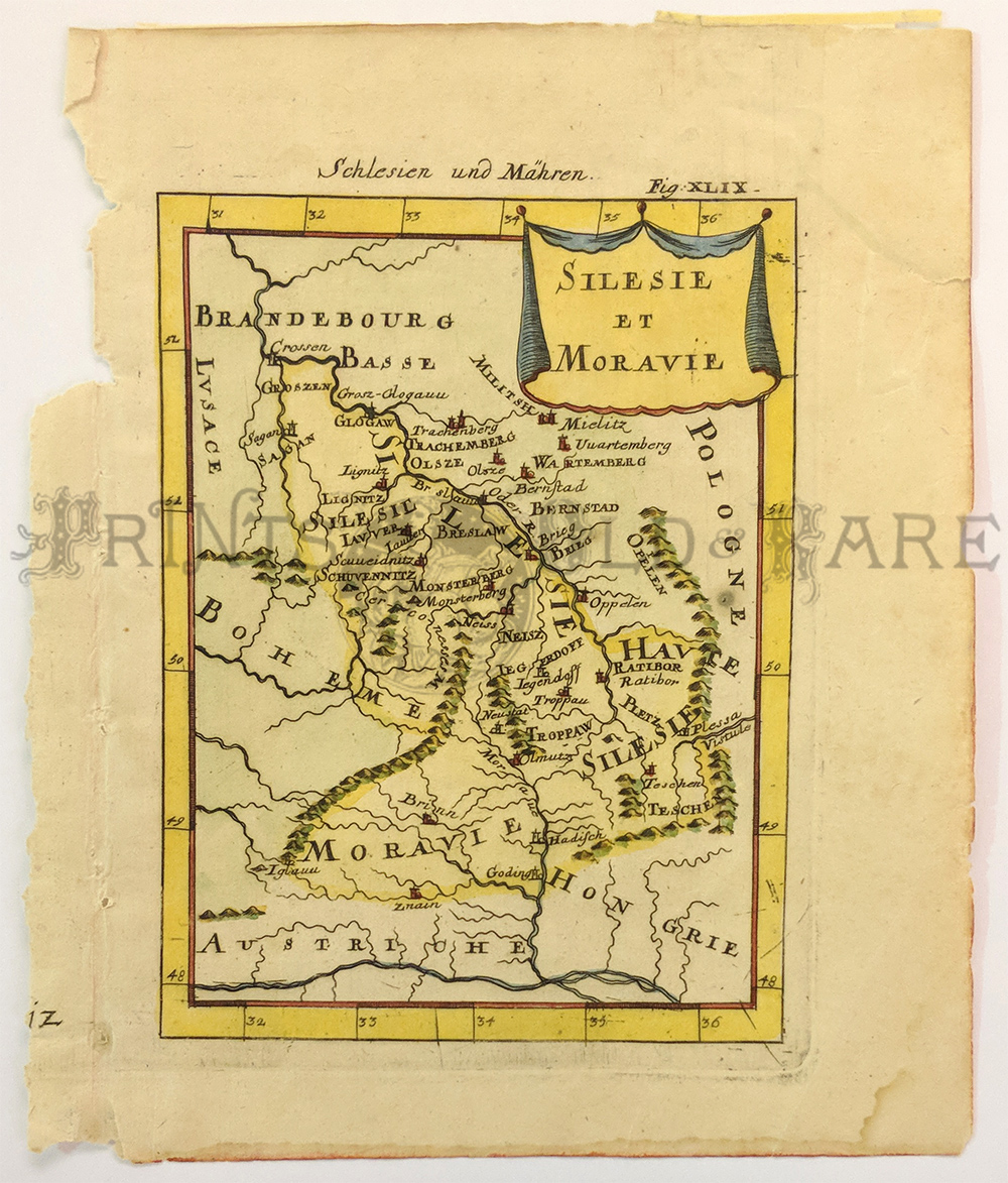
230ceur:
Silesie Et Moravie by Mallet. 1683 Hand colored copper engraving.
5.25 x 8 in. $125

231ceur:
Czech Republic - La Moravie. Small detailed map c1700. Hand colored,
Copper engraving.
5 3/4 x 7 in. $80

232ceur:
1787 Czech Republic - La Royaume de Boheme. Decorative map with
Cartouche, Coat of Arms and Battle scene. Hand colored, Copper
engraving.
8 x 10 in. $80

233ceur:
1579 Hungary "Hungariae Descriptio." Ortelius. Detailed map with
Cartouche. Hand colored, Copper engraving.
14 x 19 1/4 in. $500
234ceur:
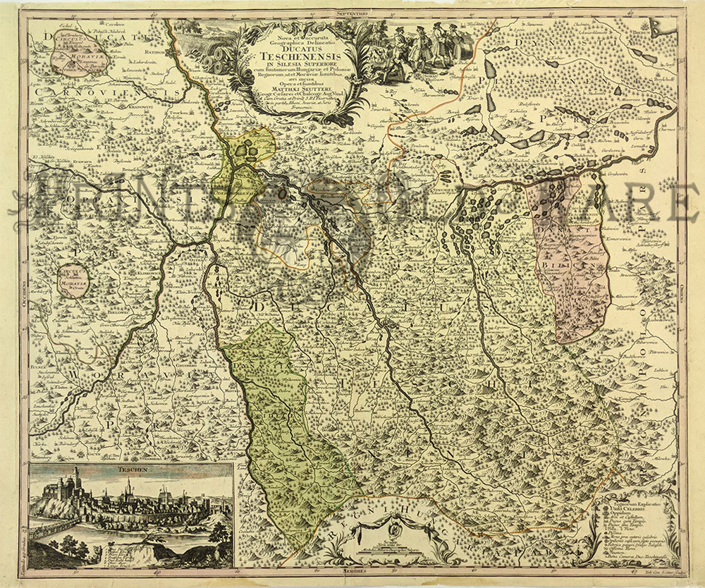
Southern Poland "Ducatus Teschensis" by Matthaus Seutter. Beautiful
Cartouche inset of Teschen. c1760. Hand colored, Copper engraving.
25 x 20 in. $400

235ceur:
Kingdom of Hungary "Regni Hungariae Tabula Generalis" by Johann Homann.
c.1720 Hand colored, Copper engraving.
24 3/8 x 20 3/4 in. $450

236ceur:
c.1750 Czech Republic "Circuli Olomucensis Pars Borealis" by Thomann
Heirs. Beautiful Cartouche plus figurative Bear Hunt scene. Good
margins. Hand colored, Copper engraving.
18.9 x 22.8in. $250

237ceur:
Austria. 1855 Colton. Showing railroads, roads, canals, capitals and
battlefields. Inset: Vicinity of Vienna. Find condition. Hand colored,
lithograph.
14 x 17 in. $20

237ceur:
Carte du Royaume de Boheme. c.1710 Chatelain. Hand colored copper
engraving. Original folds. Shows coast of arms, chronology and Moravia
Silesian.
18 ½ x 24 in. $300

238ceur:
Vienna Birdseye view of the capital of Austria located on the Danube
River. 1752 Copper engraving.
9 x 15 in. $150

240ceur:
Poland & Lithuania 1817 by Thompson. Hand colored steel
engraving. 4th Partition of Poland - color coded to countries that
controlled each part. Relif is showin by hachure with towns, cities and
major topgraphical features identified.
20 3/8 x 26 1/4 in. $250

241ceur:
1738 Europe. Hand colored copper engraved map titled, "The Atrum Belli
ad Borysthenem Tyram & Danubiam Eluvios gesti." (Theatrum
between
Dniepr and Danube Rivers). The region is the East Balkan and South
Ukraine. This is a very beautiful map of the region which is rarely
shown in one map. Map shows the ethnic mixture of nations and ethnic
groups of South Ukraine and Crimeus, and of East Balkan regions. Maker
of map is Johan Block. Map is in fine condition.
26 x 21 in.
$1150

242ceur:
Caucasus & Crimea. Hand colored, engraving by Augustus Peterson
Sebastopol. Vignettes of Sebastopol, Natives, plus gathering of Princes
of Circassia on the Banks of the Ubin (1836).
12 1/2 x 18 1/2 in. $275

243ceur:
Hungary by J. Rapkin-Tallis, 1851 – A very nice and detailed,
decorative map of Hungary with original color (including Croatia and
Transylvania) which was drawn and engraved by J. Rapkin (vignettes by a
H. Warren & J. Rogers) and published in John Tallis’ “Illustrated
Atlas” (London & New York: John Tallis & Co., c.1851)
Illustrated are views of “Pesth and the Fortress of Buda” (Budapest),
Hungarian peasants, Hungarian nobles and a scene on the Danube. Good
condition, missing small upper right outside border. Slight fold down
center with very small tear top and bottom outside border.
Size: 13.5 x 10.5 in. $100
|
|