 
|
|||||||||||
This is a small selection of our inventory of antique Sonoma County maps and prints. Additional inventory is available. Contact us with your request. 1-800-879-6277
|
|||||||||||
|---|---|---|---|---|---|---|---|---|---|---|---|
 001son: Rare 1897 antique map of Sotoyome Rancho in Sonoma County borders Mendocino County. Published from personal examinations, official records and actual surveys. Published by Reynolds and Proctor, Santa Rosa, California. "Entered according to act of Congress in the year 1897, by Reynolds & Proctor, Santa Rosa Cal." Hand colored map depicts Sotoyome Rancho & Mendocino County in detail showing land owners by name or business and acreage and railroad routes through the area. 17X17 in. $125  002son: Rare 1897 antique map of Salt Point in Sonoma County. Published from personal examinations, official records and actual surveys. Published by Reynolds and Proctor, Santa Rosa, California. "Entered according to act of Congress in the year 1897, by Reynolds & Proctor, Santa Rosa Cal." Hand colored map depicts Salt Point in detail showing land owners by name or business and acreage and railroad routes through the area. 17X17 in. $125 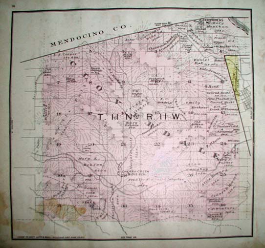 003son: Rare 1897 antique map of Cloverdale in North Sonoma County. Published from personal examinations, official records and actual surveys. Published by Reynolds and Proctor, Santa Rosa, California. "Entered according to act of Congress in the year 1897, by Reynolds & Proctor, Santa Rosa Cal." Hand colored map depicts Cloverdale in detail showing land owners by name or business and acreage and railroad routes through the area. Some water damage in lower left corner. 17X17 in. $125 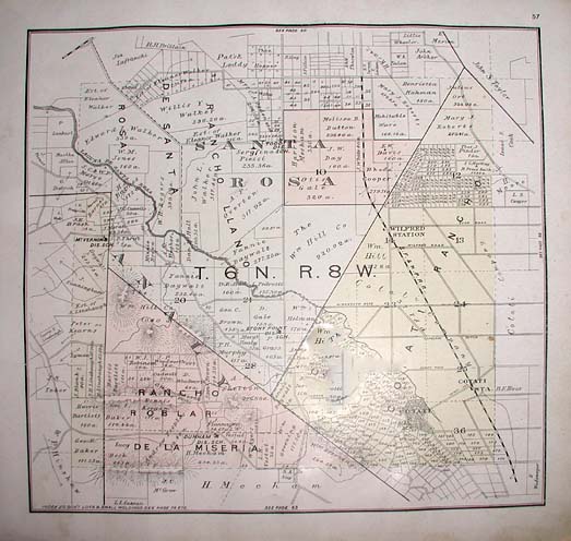 005son: Rare 1897 antique map of Cotati in Sonoma County bordering Santa Rosa. Published from personal examinations, official records and actual surveys. Published by Reynolds and Proctor, Santa Rosa, California. "Entered according to act of Congress in the year 1897, by Reynolds & Proctor, Santa Rosa Cal." Hand colored map depicts Cotati & Santa Rosa in detail showing land owners by name or business and acreage and railroad routes through the area. 17X17 in. $175  006son: Rare 1897 antique map of Bodega in Sonoma County and surrounding. Published from personal examinations, official records and actual surveys. Published by Reynolds and Proctor, Santa Rosa, California. "Entered according to act of Congress in the year 1897, by Reynolds & Proctor, Santa Rosa Cal." Hand colored map depicts Bodega in detail showing land owners by name or business and acreage and railroad routes through the area. 17X17 in. $175 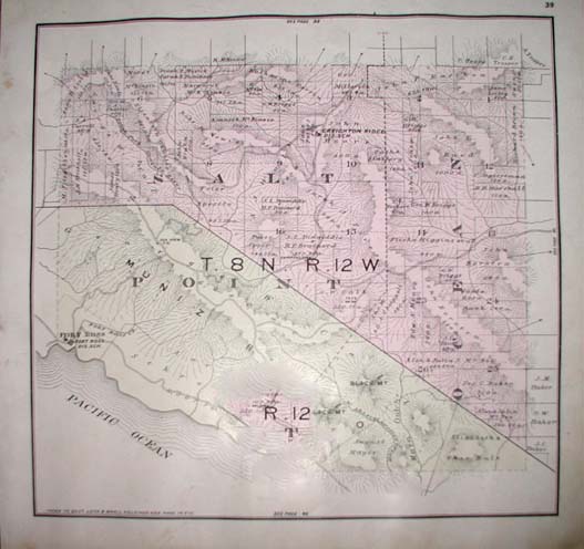 008son: Rare 1897 antique map of Fort Ross area in Salt Point. Published from personal examinations, official records and actual surveys. Published by Reynolds and Proctor, Santa Rosa, California. "Entered according to act of Congress in the year 1897, by Reynolds & Proctor, Santa Rosa Cal." Hand colored map depicts the Fort Ross area of Salt Point in detail showing land owners by name or business and acreage and railroad routes through the area. 17X17 in. $150 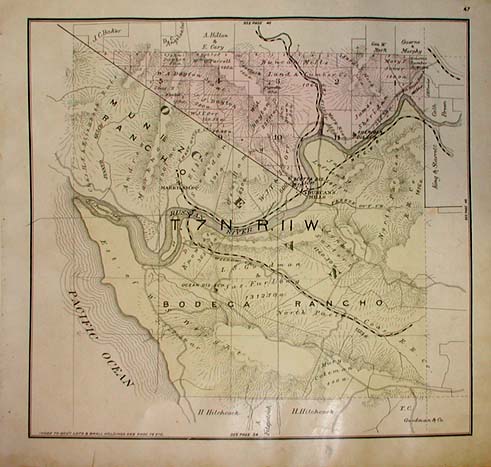 009son: Rare 1897 antique map of Bodega area in Sonoma County. Published from personal examinations, official records and actual surveys. Published by Reynolds and Proctor, Santa Rosa, California. "Entered according to act of Congress in the year 1897, by Reynolds & Proctor, Santa Rosa Cal." Hand colored map depicts Bodega area in detail showing land owners by name or business and acreage and railroad routes through the area. 17x17 in. $200 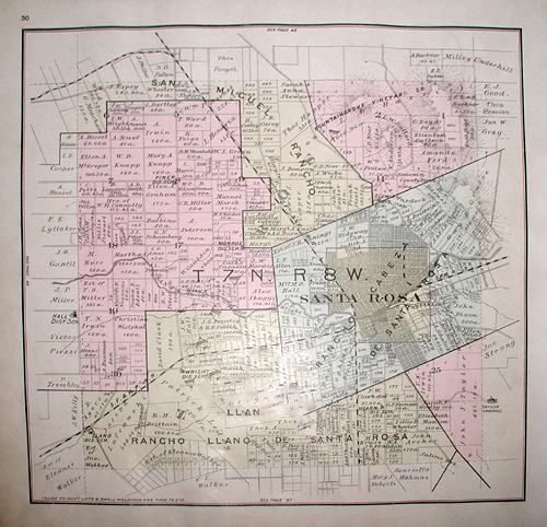 011son: Rare 1897 antique map of Santa Rosa in Sonoma County. Published from personal examinations, official records and actual surveys. Published by Reynolds and Proctor, Santa Rosa, California. "Entered according to act of Congress in the year 1897, by Reynolds & Proctor, Santa Rosa Cal." Hand colored map depicts Santa Rosa and vicinity in detail showing land owners by name or business and acreage and railroad routes through the area. 17X17 in. $200 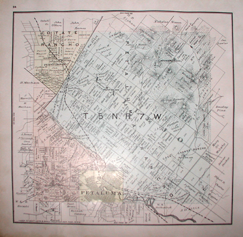 0014son: Rare 1897 antique map of Petaluma & Vallejo in Sonoma County. Published from personal examinations, official records and actual surveys. Published by Reynolds and Proctor, Santa Rosa, California. "Entered according to act of Congress in the year 1897, by Reynolds & Proctor, Santa Rosa Cal." Hand colored map depicts Petaluma & Vallejo in detail showing land owners by name or business and acreage and railroad routes through the area. 17X17 in. $200  015son: Rare 1897 antique map of Sonoma & Vallejo in Sonoma County. Published from personal examinations, official records and actual surveys. Published by Reynolds and Proctor, Santa Rosa, California. "Entered according to act of Congress in the year 1897, by Reynolds & Proctor, Santa Rosa Cal." Hand colored map depicts Sonoma & Vallejo areas of San Pablo Bay, Sears Point and the town of McGill's in detail showing land owners by name or business and acreage and railroad routes through the area. Also shown is the Sears Point area and the Napa Solano county lines. 17X17 in. $200 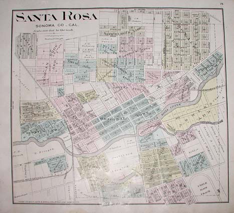 016son: Rare 1897 antique city map of Santa Rosa in Sonoma County. Published from personal examinations, official records and actual surveys. Published by Reynolds and Proctor, Santa Rosa, California. "Entered according to act of Congress in the year 1897, by Reynolds & Proctor, Santa Rosa Cal." Hand colored map depicts Santa Rosa in detail showing land owners by name or business and acreage, railroad routes through the area and addresses along streets in the town of Santa Rosa. 17X17 in. $250 |
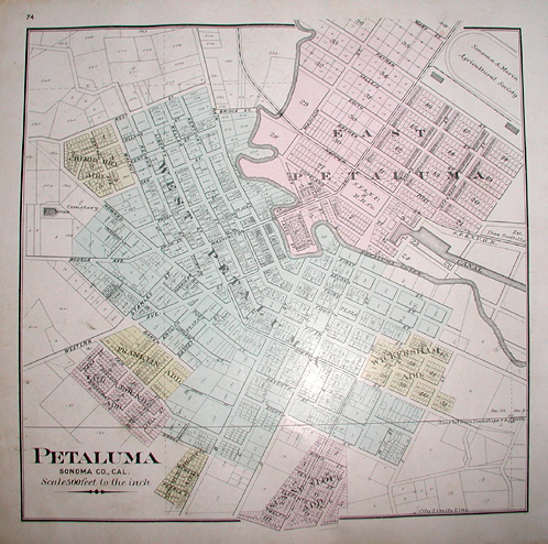 017son: Rare 1897 antique city map of Petaluma in Sonoma County. Published from personal examinations, official records and actual surveys. Published by Reynolds and Proctor, Santa Rosa, California. "Entered according to act of Congress in the year 1897, by Reynolds & Proctor, Santa Rosa Cal." Hand colored map depicts Petaluma in detail showing land owners by name or business and acreage and railroad routes through the area and addresses along streets in the town of Petaluma. 17X17 in. $350  018son: Rare 1897 antique map of Bodega Bay Corners in Sonoma County. Published from personal examinations, official records and actual surveys. Published by Reynolds and Proctor, Santa Rosa, California. "Entered according to act of Congress in the year 1897, by Reynolds & Proctor, Santa Rosa Cal." Hand colored map depicts Bodega Bay Corners in detail showing land owners by name or business and acreage and railroad routes through the area. 17X17 in. $200 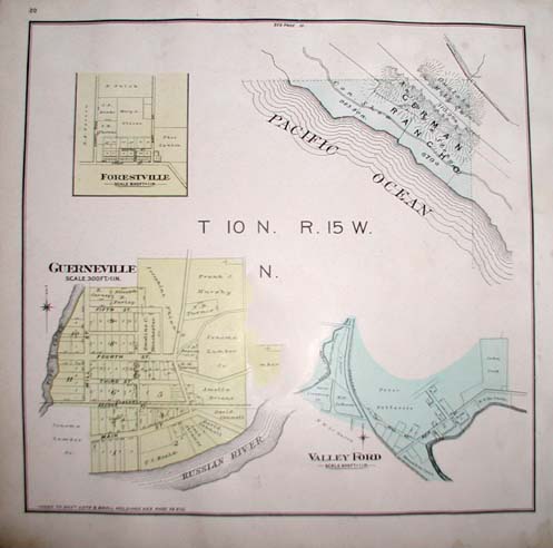 021son: Rare 1897 antique map of Guerneville, Forestville, Valley Ford and German Rancho in Sonoma County. Published from personal examinations, official records and actual surveys. Published by Reynolds and Proctor, Santa Rosa, California. "Entered according to act of Congress in the year 1897, by Reynolds & Proctor, Santa Rosa Cal." Hand colored map depicts Guerneville, Forestville, Valley Ford and German Rancho in detail showing land owners by name or business and acreage and railroad routes through the area. 17X17 in. $175 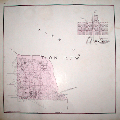 023son: Rare 1897 antique map of the St. Helena and Occidental areas in Sonoma County. Published from personal examinations, official records and actual surveys. Published by Reynolds and Proctor, Santa Rosa, California. "Entered according to act of Congress in the year 1897, by Reynolds & Proctor, Santa Rosa Cal." Hand colored map depicts these areas in detail showing land owners by name or business and acreage and railroad routes through the area. 17X17 in. $150  024son: Rare 1897 antique map of Mendocino. Published from personal examinations, official records and actual surveys. Published by Reynolds and Proctor, Santa Rosa, California. "Entered according to act of Congress in the year 1897, by Reynolds & Proctor, Santa Rosa Cal." Hand colored map depicts Mendocino in detail showing land owners by name or business and acreage and railroad routes through the area. 17X17 in. $125  026son: Rare 1897 antique map of the city of Cloverdale in Sonoma County. Published from personal examinations, official records and actual surveys. Published by Reynolds and Proctor, Santa Rosa, California. "Entered according to act of Congress in the year 1897, by Reynolds & Proctor, Santa Rosa Cal." Hand colored map depicts Cloverdale in detail showing land owners by name or business and acreage and railroad routes through the area. Also shown are addresses on individual streets in the area. 17X17 in. $175 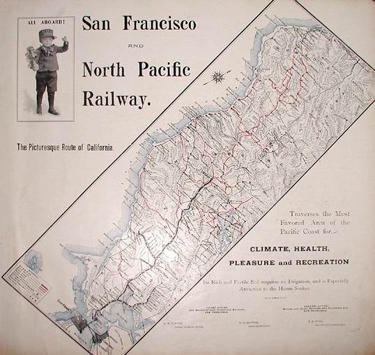 027son: Rare 1897 antique advertising map of the San Francisco & North Pacific Railway, the Picturesque Route of California. "Traverses the most favored area of the Pacific Coast for Climate, Health, Pleasure and Recreation. Its Rich and Fertile Soil requires no Irrigation, and is Especially Attractive to the Home Seeker." This extremely detailed map also shows stage routes, ferry lines, wagon roads, county boundaries, principal towns and resorts, salt marshes, redwood timber belt and coal fields. Little boy in upper right corner wearing a San Franciso and North Pacific Railway engineers cap, caption reads 'ALL ABOARD!'. Small tear that has been mended in margin on lower right corner, does not detract from the map at all. 17x17 in. $425  028son: Scenery around Petaluma from 1897. Showing the Grammar School Building, D Street School Building, Interior view of the Public Library, Pepper Kindergarten School and High School Building. Extremely detailed article on the history of Petaluma from 1846 to Present (1897) describing Transportation, Schools, Libraries, Attractions, Advantageous Locations, Manufacturing, etc. 17X17 in. $150 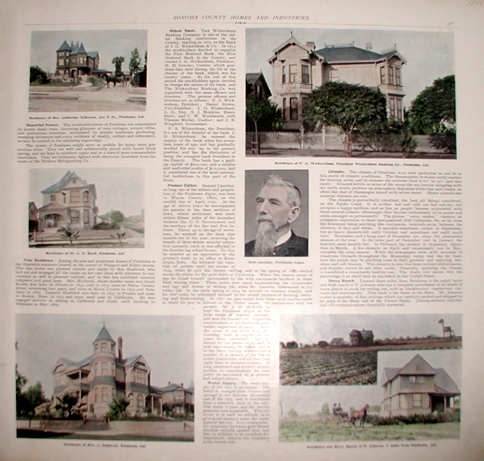 029son: Scenery around Petaluma from 1897. Showing the fine residences of Petaluma and Sam Cassidy. Extremely detailed article on the history of Petaluma (1897) describing Homes, Banks, Pioneer Editor Sam Cassidy and Berry Ranch. 17X17 in. $125 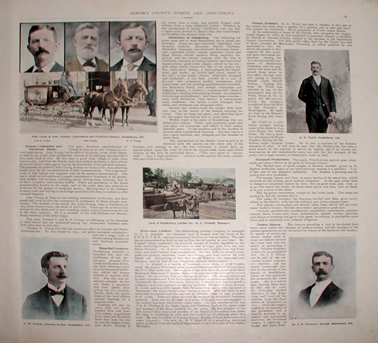 030son: Scenery around Healdsburg from 1897. Showing John Young & Sons - Pioneer Undertakers and Furniture Dealers, Norton - Attorney, Yard of Healdsburg Lumber, Truitt - Truitt Opera House, O'Connor - Dentist. Extremely detailed article on the history of Healdsburg (1897) describing the pioneers of the area. 17X17 in. $150 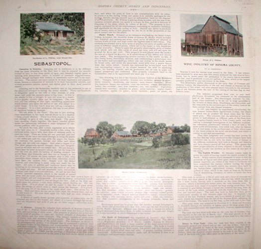 031son: Scenery around Sebastopol from 1897. Showing the Wine Industry of Sonoma. Extremely detailed article on the history of Sebastopol (1897) describing Camping in Sonoma, Various Ranches of Sebastopol, Dance in Wine Tank, etc. 17X17 in. $175 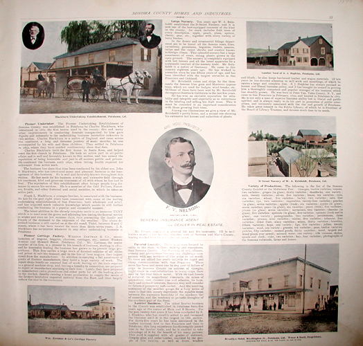 032son: Scenery around Petaluma from 1897. Showing Blackburn undertaking establishment, Wm. Zartman & Co's Carriage Factory, Nelson - General Insurance Agent and Dealer in Real Estate, Lumber Yard of Hopkins, D Street Nursery of Reinholdt and Brooklyn Hotel on Washington Street. Extremely detailed article on the history of Petaluma (1897) describing the pioneers and establishments of the area. 17X17 in. $200 |
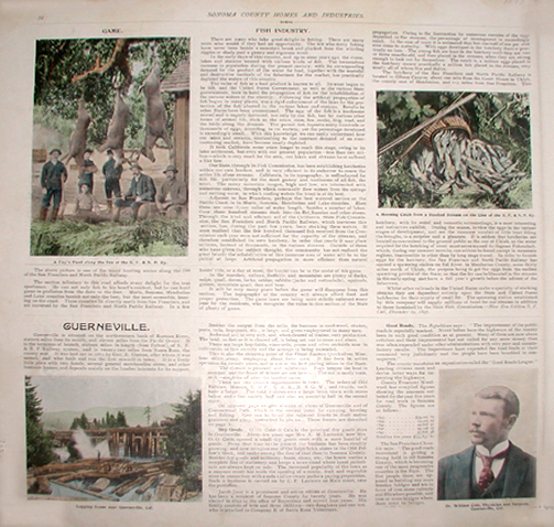 033son: Scenery around Guerneville from 1897. Showing Hunting & Fishing along the line of the San Francisco and North Pacific Railway, Logging and Surgeon of Guernville William Cole. Extremely detailed article on the history of Guerneville (1897) describing the pioneers of the area. 17X17 in. $150  034son: Scenery around Cloverdale the Orange Belt of Sonoma County from 1897. Showing Orange trees and the interior view of the Orange Exhibit held in 1897. Extremely detailed article on the history of Cloverdale (1897). 17X17 in. $180 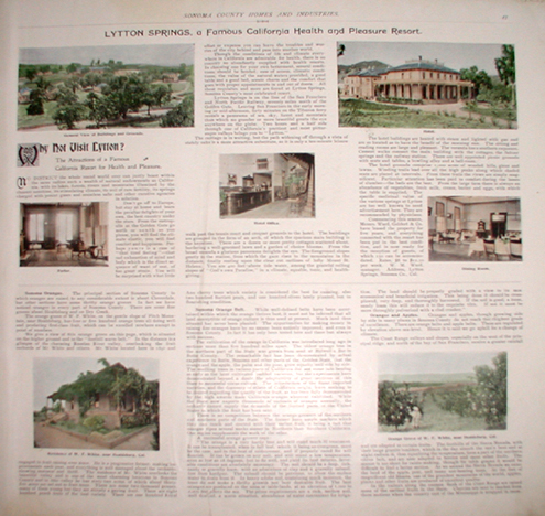 035son: Scenery around Lytton Springs, a Famous California Health and Pleasure Resort from 1897. Showing Buildings and the Grounds, Residences, Hotel and the Orange Grove of Healdsburg. Extremely detailed article on the history of Lytton Springs in Healdsburg (1897). 17X17 in. $150 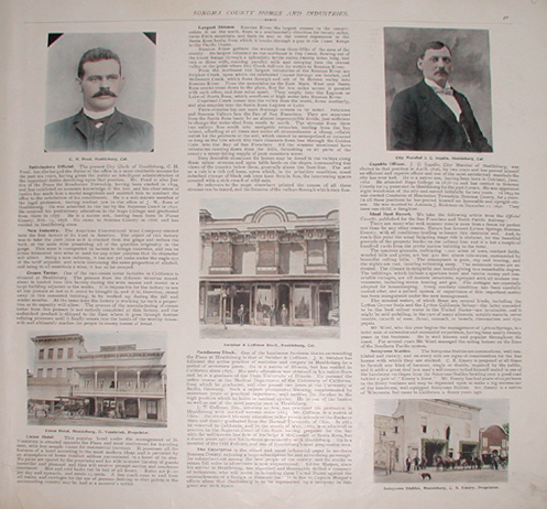 036son: Scenery around Healdsburg from 1897. Showing members of Healdsburg Society and thriving businesses such as Union Hotel, Swisher & Coffman Block (medical & law professions), Sotoyome Stables. Also shows the City Marshall Ingalls elected in 1896. Extremely detailed article on the history of Healdsburg (1897) describing the pioneers of the area and information on the largest stream, the Russian River. 17X17 in. $125 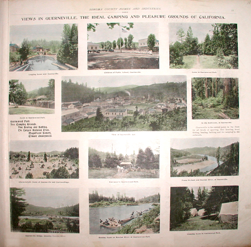 037son: Views in Guerneville, the Ideal Camping and Pleasure Grounds of California from 1897. Showing Logging, Children at school, Guernewood Park, Aerial View of Guerneville, Redwoods of Guerneville, View of Guerneville & Surroundings, Entrance to Guernewood Park, Prune Orchard and Russian River at Guerneville, Guerneville Bridge crossing Russian River, Boating on the Russian River at Guernewood Park and Camping Scene at Guernewood Park. Extremely detailed views of the area as it once was in 1897. 17X17 in. $275  038son: The Scenic Route of California (Scenes on Line of North Pacific Coast Railway) from 1897. Showing Moscow Cottage, Duncans Mills, Sausalito, Mill Valley, San Rafael and Mesa Grande on the Russian River. Extremely detailed article about this route on the line of the North Pacific Coast Railway. 17X17 in. $250  039son: Scenery around Healdsburg and Her Rich Resources from 1897. Showing City Hall & Library, West Street Looking South, West Steet from North Street to Mathewson Street, Plaza & City Hall Fitch Mountain in the Distance and Powell Street East side of Plaza looking from West Side of West Street. Extremely detailed article on the history of Healdsburg. Listed are the City Officials Barnes - President, Pyne, Favour, Wolcott, Merchant - Trustees, Pond - Clerk, Warfiled - Treasurer, Ingalls - Marshall and Moreland & Norton - City Attorneys (1897). 17X17 in. $250  041son: Scenery around El Rancho Cotati from 1897. Showing Birds Eye View of the Rancho Cotati, Glimpse of the Valley and the Rolling land. Extremely detailed real estate information on California Homes, Suitable for Villa Sites, fruit, berry, vine, hop, sugar beet, grain, vegetable and dairy farms and information on what gives value to Rancho Cotati (1897). 17X17 in. $175  042son: Scenery of Model California Vineyard and Wineries 1897. Showing Chianti Vineyards from which is made the celebrated "Tipo Chianti Wine", Panoramic View of Vineyards and Winery at Asti, Russian River is in Foreground, Winery and Distillery of the Italian - Swiss Colony at Asti, View of the Burgundy Vineyards of the Italian - Swiss Colony at Asti and the Half Million Gallon Wine Tank, The Largest in the World. Extremely detailed article on a Typical Colony (1897). 17X17 in. $300  043son: Views along the Line of the San Francisco and North Pacific Railway, the Picturesque Route of California from 1897. Showing Hop Yard, Vineyard, The Devil's Canyon at the Geysers, San Francisco and North Pacific Railway Fish Hatchery in Gibson Canyon near Ukiah, Pendulous Oak, Gateway to Bohemia - Redwood Forest near Guerneville, Interior View of San Francisco and North Pacific Railway Hatchery, Where the Trout Hide and Stock Farm. Extremely detailed views along the railway (1897). 17X17 in. $220 |
|||||||||
| Order Form | |||||||||||
| Back to Homepage | |||||||||||